
March 22, 2022
Pashleth Glacier, BC Retreat Driven Fragmentation 1987-2021
Posted by Mauri Pelto
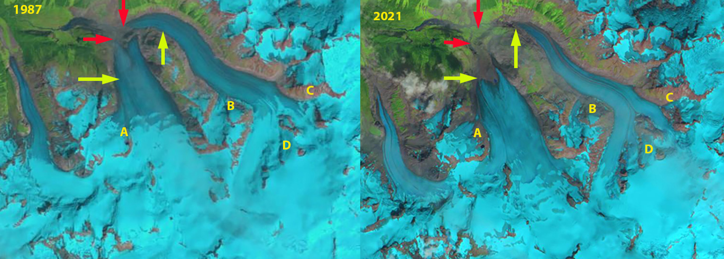
Pashleth Glacier in 1987 Landsat and 2021 Sentinel image. Red arrow is 1987 terminus location, yellow arrow 2021 terminus location. Point B-D mark locations where separation has or is occurring along the main glacier and Point A on the western arm.
Pashleth Glacier, British Columbia drains into Pashleth Creek a tributary to the Machmell River, Owikeno Lake and then River Inlet on the British Columbia Coast. Here we examine the glacier retreat and fragmentation that has occurred from 1987-2022. The Machmell River is an important salmon spawning area in its lowest 20 km, particularly for sockeye, with chinook, coho, pink and chum salmon up to the cascades just downstream of junction with Pashleth Creek (Hillaby, 1998). The Rivers Inlet fjord had the third largest run in the province with annual returns of up to 3.1 million sockeye from 1948 to 1992 (Hakai, 2021). The Rivers Inlet sockeye stock has recently received much attention because of a dramatic decline in total abundance from the with an estimated 94% decline in sockeye salmon equilibrium population size (from 3,115,000 to 200,000) hitting a low of under 10,000 in 1999 (Adams et al 2021). In the 1980’s Machmell River escapement numbers averaged 20,000, dropping to 5000 in the 1990’s (Rutherford et al 1998). Harvest rates were reduced in the 1980’s and the commercial fishery closed in 1996. The commercial fishery has remained closed since 1996, with a small amount of fishing permitted by the Wuikinuxv First Nation maintain a modest food, social, and ceremonial harvest. The Rivers Inlet sockeye salmon stock has experienced limited recovery consistently exceeding ~100,00o, and averaging ~250,000 in the last two decades (Adams et al 2021). The study also examined the decline in grizzly bear population and the connection to salmon decline. They observed grizzly bear diet finding the percentage of the diet from salmon declined from ~70% pre-collapse to 23% in the 1990’s and rebounding today with fewer grizzly bears to 64%.
In 1987 Pashleth Glaciers main terminus was at 1000 m and the west terminus at 1100 m, with the snowline at 1700 m. By 2000 significant retreat has occurred and tributaries at Point A-D are all feeding the main glacier. The snowline is at 1800 m in 2000. In 2014 tributaries A-D are still feeding the main glacier. The snowline is at 2000 m in 2014. In 2020 Brian Menounos and Ben Pelto (UNBC) visited the accumulation area of this glacier at 2300 m and found 4.2 m of snow remaining, see below. This area has retained accumulation each and every year. In 2021 tributaries at Point A and B have separated from the main glacier, while the tributary at Point C is on the verge of separation, likely will happen in 2022. At Point D this region is developing a rock rib that indicates contribution from this small triburary is limited and will cease in the near future. The snowline in late August is at 1950 m. The main terminus has retreated 1250 m from 1987-2021 and the west arm 1700 m.
Pashleth Glacier is a large glacier that will continue to supply a large magnitude of summer glacier runoff. The challenge for the salmon will continue to be in the ocean. The neighboring Klippi Glacier retreated 1400 m from 1987-2016, with the two main branches having separated and also feeds the Machmal River. Draining the same icefield to the south Klinaklini Glacier is also rapidly retreating (The Tyee, 2021).

Pashleth Glacier in 1987 and 2014 Landsat image Red arrow is 1987 terminus location, yellow arrow 2021 terminus location. Point B-D mark locations where separation has or is occurring along the main glacier and Point A on the western arm.

Brain Menounos, UNBC probing snowpack on the upper glacier. Searching for a potential measurement station high on the glacier (Image from Ben Pelto).
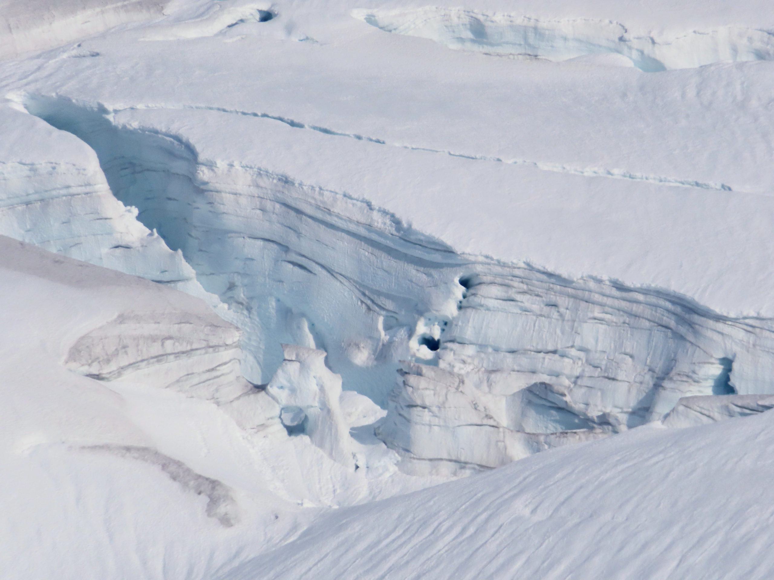
Crevasse stratigraphy indicates the depth of retained accumulation on upper glacier ( (Image from Ben Pelto)
 Dean of Academic Affairs at Nichols College and Professor of Environmental Science at Nichols College in Massachusetts since 1989. Glaciologist directing the North Cascade Glacier Climate Project since 1984. This project monitors the mass balance and behavior of more glaciers than any other in North America.