
January 12, 2022
Braithwaite Icefield, British Columbia Fragments, Proglacial Lakes Develop and Accumulation Zone is Lost
Posted by Mauri Pelto
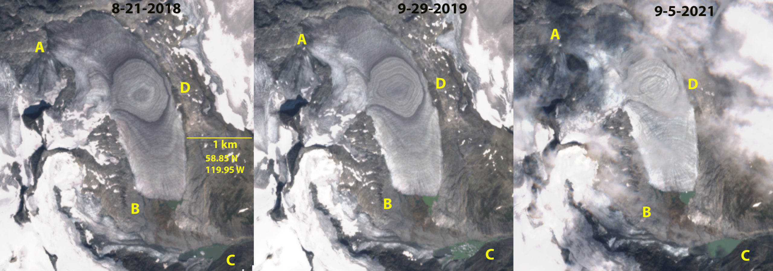
East Creek Glacier, a Braithwaite Icefield glacier in Sentinel images from 2018, 2019 and 2021 illustrating the at Point A and B where the glacier has disconnected from other glaciers of the icefield . Point C is a the terminus of one icefield outlet glacier that develops a proglacial lake. Point D is adjacent to the ice divide where ice flows both north and south from. Note the area is snow free in 2018, 2019 and 2021. The ice divide has ~12 annual layers exposed as rings.
The Braithwaite Icefield is east of Hobson Lake is in the Columbia Mountains an interior range of British Columbia. Our focus here is on a glacier at the headwaters of East Creek, “East Creek ” Glacier. This glacier has experienced changes that exemplify the recent changes of glaciers across western Canada. An extensive western Canada glacier inventory of the 1984-2020 period using optical satellite imagery noted an accelerated area loss Bevington and Menounos (2022). Specifically they quantified glacier fragmentation accelerated from 26 to 88 occurrences per year. They note that about 1141 glaciers disappeared from the inventory falling below the 0.05 km2 detection limit. The retreat also led to proglacial lake area formation accelerating from ~9 km2/year to 49 km2/year.
In 1987 East Creek Glacier accumulation zone adjacent to Point D drains north and south to separate terminus areas. In 1987 the outlet glacier that terminates at Point C is connected at Point B to the East Creek Glacier at its southern terminus. Adjacent to its northern terminus it is connected at Point A to another icefield glacier. By 2015 the glacier has separated at Point B from the outlet glacier terminating at Point C. There is not retained accumuluation at the glacier divide adjacent to Point D. This exposes a ring of ~12 annual layers preserved in glacier ice, from former annual accumulation layers that had been retained. In the ensuing summers of 2016, 2017, 2018 2019 and 2021 all of the snowpack was lost. Two proglacial lakes have formed, the area of the lake at the East Creek southern margin is 0.03 km2, the area of the lake at Point C is now 0.1 km2 .
The persistent lack of an accumulation zone indicates the glacier cannot survive (Pelto, 2010). The glacier still has an area of 2.5 km2, that will allow it to endure for several decades. Ben Pelto, and Menounos a(2021) reported that the mass balance of Zillmer Glacier, due east in the same range, had a mean negative balance of ~-0.7 m/year from 2014-2018, with an average ELA of 2465 m. The glacier had a mean altitude of 2380 m and a high elevation of 2860 m. The mean elevation of Zillmer Glacier is higher than the divide on East Creek Glacier, which along with a relatively steep mass balance gradient of 5 to 8 mm w.e. m-1, leads to the glacier maintaining an accumulation zone. The retreat is not as substantial as many glaciers in the region, note Kiwa Glacier or Franklin Glacier, but the overall changes are profound.
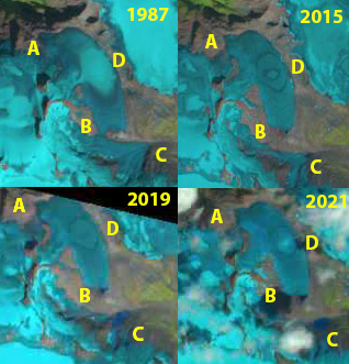
East Creek Glacier a Braithwaite Icefield glacier in Landsat images from 1987, 2015, 2019 and 2021 illustrate the changes. Point A and B are points where the glacier is connected to other glaciers of the icefield that separate-fragment during this period. Point C is a the terminus of one icefield outlet glacier that develops a proglacial lake. Point D is adjacent to the ice divide where ice flows both north and south from. Note the area is snow free in 2015, 2019 and 2021.
 Dean of Academic Affairs at Nichols College and Professor of Environmental Science at Nichols College in Massachusetts since 1989. Glaciologist directing the North Cascade Glacier Climate Project since 1984. This project monitors the mass balance and behavior of more glaciers than any other in North America.