
November 4, 2021
Drogpa Nagtsang Glacier, China 2021 Snow Line Positions Lake Expansion
Posted by Mauri Pelto

Drogpa Nagtsang Glacier, China retreat and proglacial expansion in 1993 and 2021 Landsat images. Red arrow is the 1993 terminus, yellow arrow the 2021 terminus and yellow dots are the snowline.
Drogpa Nagtsang Glacier, China is 30 km west of Mount Everest terminating in an expanding proglacial lake. The glacier begins on the Nepal border at 6400 m, and its meltwater enters the Tamakoshi River that supplies the Upper Tamakoshi Hydropower project a 456 MW run of river project that began operation in September 2021. King et al (2017) observed the mass balance of 32 glaciers in the Mount Everest area including Drogpa Nagtsang and found a mean mass balance was -0.7 m/year for lake terminating glaciers. In this basin from 2000–2016, mass balance loss resulted in surface elevation to decline at a rate of −0.63 m a−1, which drove a velocity decline of ~25% (Zhong et al 2021). They also noted that the area of proglacial lakes in glacier contact increased by ~204% . Pelto et al (2021) documented the exceptionally high winter snowline in the Mount Everest region from October 2020-January of 2021. Here we examine changes in Drogpa Nagtsang Glacier since 1993 and the snowline variation from October 2020-November 2021.
In 1993 Drogpa Nagtsang Glacier had a substantial number of coalescing supraglacial ponds on its relatively flat stagnant debris covered terminus. The snowline in 1993 was at ~5450 m. At Point A there is extensive crevassing indicating vigourous flow. At Point B a tributary glacier joins the main glacier. At Point C the glacier is a 1.2 km wide glacier tongue. Quincey et al (2009) observed flow of less than 10 m/a in lower 5 km of glacier in 1996 and peaking at 20-30 m/a 8 km from terminus. By 2015 a 2.7 km long lake has developed (Pelto, 2019). In 2021 the lake has expanded to 3 km long. At Point A there is no longer significant crevassing indicating reduced flow. At Point B the tributary no longer connects to main glacier. At Point C the glacier tongue has lost 30% of its width and debris cover width has expanded. The terminus area remains stagnant and the lake is poised to continue expansion.
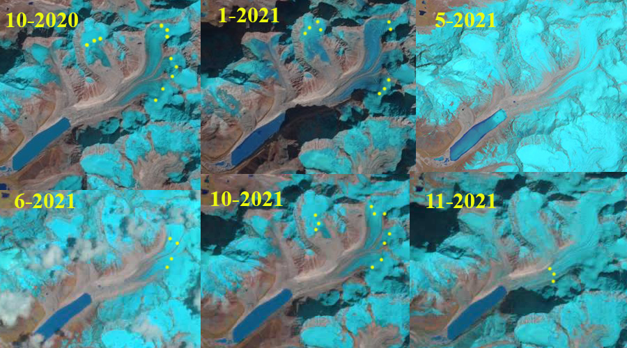
Snowline variation from October 2020-November 2021, yellow dots. These are Landsat images except May 2021 is from Sentinel.
In October 2020 the snowline on Drogpa was at 5650-5700 m. By mid-January after the record winter heat wave of 2021 the snowline had risen to 5750-5800 m. In May of 2021 as the summer monsoon began the snowline was below the terminus of the glacier (5000 m). In June the snowline had risen to 5450 m. This is a summer acccumulation type of glacier, which means most of the accumulation snowfall occurs during the summer monsoon above the snowline simultaneous with high melt rates below the snowline. The snowline is close to mean freezing level, which has risen to 5400 m in recent years for the summer monsoon period (Perry et al 2020)The snowline than rises in the post-monsoon period. By October 2020 in the post-monsoon period the snowline had rise to 5600 m. A significant storm in late October lowered the snowline to 5250 m for November 2021. This suggests the snow free start to winter we saw last year will not occur this year.
 Dean of Academic Affairs at Nichols College and Professor of Environmental Science at Nichols College in Massachusetts since 1989. Glaciologist directing the North Cascade Glacier Climate Project since 1984. This project monitors the mass balance and behavior of more glaciers than any other in North America.