
July 9, 2021
Porcupine Glacier, British Columbia Southern Terminus Breakup
Posted by Mauri Pelto
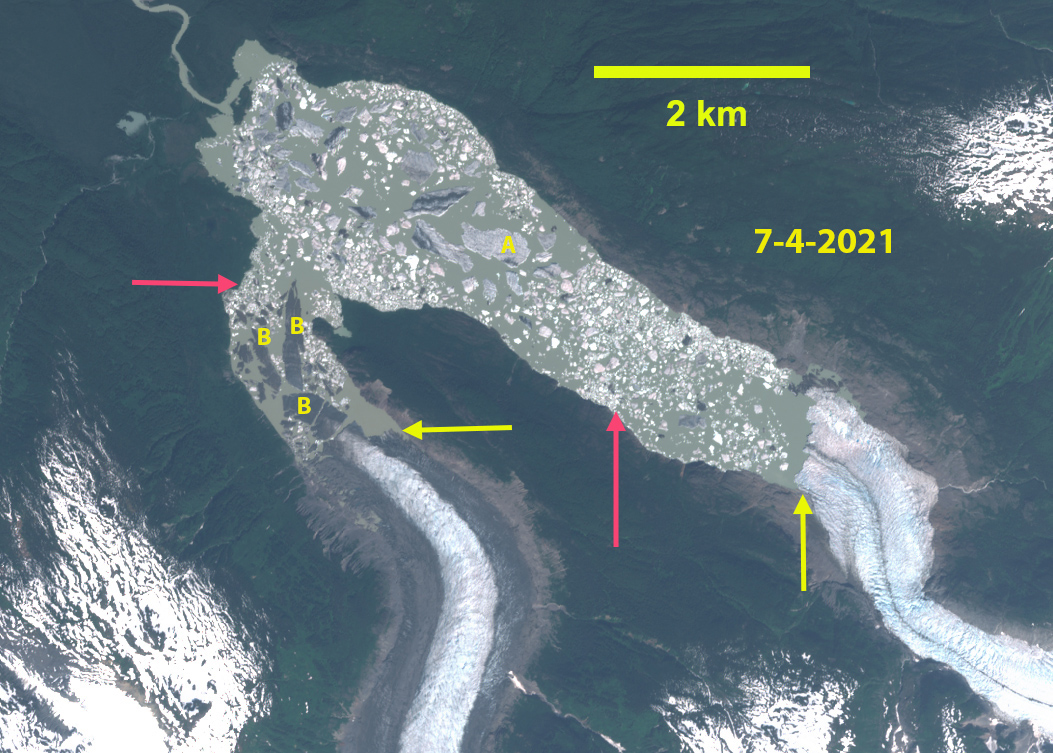
Porcupine Glacier, British Columbia in a July 4, 2021 Sentinel image illustrating the retreat from 2015-2021 and new iceberg breakup (B). Red arrow is 2015 terminus location and yellow arrows 2021 terminus locations of both branches.
Porcupine Glacier is a 20 km long outlet glacier of an icefield in the Hoodoo Mountains of Northern British Columbia that terminates in an expanding proglacial lake. During 2016 the glacier had an unusually large 1.2 km2 iceberg break off (A) the iceberg is still present. NASA generated better imagery to illustrate this observation. The southern branch of the glacier has a tongue poised to breakup at that time (B). Menounos et al (2018) identified a mass loss for glaciers in this region of ~0.6 m year from 2000-2018 which is driving retreat. Here we examine the change in terminus position and iceberg deterioration from 2015-2021 using Landsat and Sentinel images.
In 2015 the glacier had retreated 3.1 km from the 1988 location (Pelto, 2016). In 2015 there are two tongues of the glacier vulnerable to calving at Point A and B. In 2016 Iceberg A has calved generating an immediate retreat of 1.7 km. In June of 2017 the iceberg size has been reduced 10-15%, with little change in position. The iceberg is plugging smaller icebergs from moving down the lake. In August 2018 the iceberg because of its size has still drifted little and at 0.6 km2 has lost half of its area in the two years. This has enabled smaller icebergs to move past the iceberg down the lake. In July of 2019 the iceberg has diminished further to 0.45 km2, but is enmeshed in a melange of other icebergs as well. The glacier has continued to retreat from 2016 to 2019 as expected, ~500 m. The glacier tongue at Point B narrowed considerably from 2015 to 2019 and is poised to separate. The narrowness and potentially shallower depth of this inlet may make it difficult for a single iceberg to emerge from the collapse of this glacier tongue. Iceberg B calved in the summer of 2020 and by July of 2021 is in four main pieces. The retreat of the main terminus from 2015-2021 is 2000 m and for the southern branch it has been 1600 m.
The retreat rate is greater than that at Dawes Glacier to the west in Alaska or Jacobsen Glacier to the south in British Columbia.
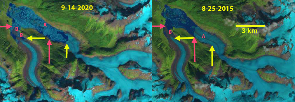
Porcupine Glacier in Landsat images from 2015 and 2020. Ice tongue A and B are indicated for 2015 and then Iceberg A and B for 2020. 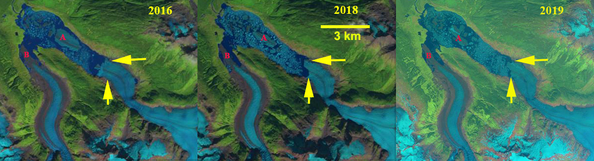
Porcupine Glacier in Landsat images from 2016 and 2018 and 2019 Sentinel Image. Iceberg A and Ice tongue B are indicated on each. The haziness in 2019 is forest fire smoke. The yellow arrows mark the 2019 terminus location.
 Dean of Academic Affairs at Nichols College and Professor of Environmental Science at Nichols College in Massachusetts since 1989. Glaciologist directing the North Cascade Glacier Climate Project since 1984. This project monitors the mass balance and behavior of more glaciers than any other in North America.