May 22, 2021
Mena Kang West Glacier retreat and lake expansion, Tibet, China
Posted by Mauri Pelto
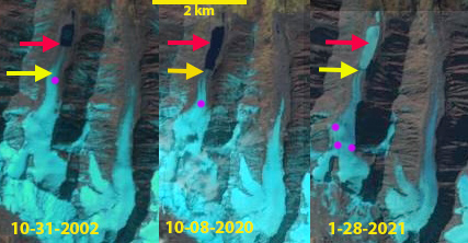
Mena Kang West Glacier in 2002, 2020 and 2021 Landsat images. Red arrow is the 2000 terminus location, yellow arrow the 2021 terminus location and pink dots the snowline.
“Mena Kang West” Glacier is an unnamed glacier that is to the west of Mena Kang (6140 m) at 28 N, 91.6 W in Tibet, China. The glacier drains into the Nyamjang Chu, which flows south in Arunachal Pradesh, India. This region has seen the rapid expansion of many proglacial lakes due to glacier retreat. Allen et al (2019) mapped 1291 glacial lakes with an area greater than 0.1 km2, of these 204 posed a glacial lake outburst (GLOF) threat. Nyamjang Chu is not a basin that has experienced a significant GLOF. This basin does have a proposed hydropower project downstream in Arunachal Pradesh, but the project has not yet begun. Glacier retreat led to a 20% increase in the number of glacier lakes in the Pumqu region, the adjacent basin to the west (Che et al, 2014).
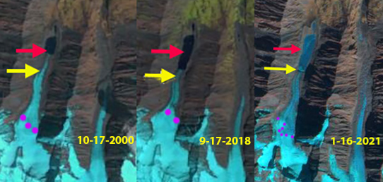
In 2000 the glacier terminates, at ~4820 m, in a 400 m long glacial lake with an area of 1.6 km2. The snowline is near the top of an icefall at 5300 m. In late October 2002, the snowline is at 5100 m, the lake area is 1.7 km2. By 2016 the glacial lake has expanded to 1000 m in length, the terminus is just below a crevassed area (C), indicating the calving front is leading to an acceleration of the glacier near its terminus. The snowline is at the top of the icefall at ~5300 m. In October 2020 a snowstorm has lowered the snowline to 5000 m. A warm dry early winter and particularly January throughout the region (NASA, 2021), has led to the snowline have risen and remained high at 5300-5400 m from January 16 -January 28, 2021. This is a summer accumulation glacier receiving the bulk of its snowfall in summer, but winter is supposed to be a period with some snowcover and limited ablation. That was not the case in the snow free winter to the end of January in 2020/21 (Pelto, 2021). By 2020 the glacier has retreated 600 m since 2000 and the lake area has expanded to 0.3 km2. The high snowlines in recent years have been driving further retreat as noted at other glaciers in the area; Shie Glacier and Bailang Glacier.
Digital Globe imagery from 2018 of Mena Kang West Glacier illustrating the Icefall (I) at ~5300 m, the terminus crevasse zone (C), flow directions (blue arrows), snowline (pink dots) and recessional moraines (M).
Mena Kang West Glacier in 2000 and 2018 Landsat images and a 2021 Sentinel image. Red arrow is the 2000 terminus location, yellow arrow the 2021 terminus location and pink dots the snowline.


 Dean of Academic Affairs at Nichols College and Professor of Environmental Science at Nichols College in Massachusetts since 1989. Glaciologist directing the North Cascade Glacier Climate Project since 1984. This project monitors the mass balance and behavior of more glaciers than any other in North America.