May 13, 2021
Herz Glacier, South Georgia Loses 25% of its Length 1989-2021
Posted by Mauri Pelto
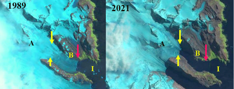
Landsat images from 1989-2021 of Herz Glacier. Red arrow is 1989 terminus location, yellow arrows the 2021 terminus location. I=Iris Bay.
Herz Glacier is on the southeast coast of South Georgia Island, and is adjacent to the Twitcher Glacier. The terminus change of this tidewater glacier ending in Iris Bay was completed by the British Antarctic Survey for the 1960-2011 period, see map below (Gordon et al, 2008). This map indicates the slow retreat from 1960-1988 and a more rapid retreat since. Here we utilize Landsat imagery from 1989-2021 to examine terminus change.
In 1989 the glacier is 10 km long with the terminus located in the east trending arm of Iris Bay at a point where it widens substantially. Point A is the midway point of the glacier. By 2002 the terminus has retreated ~1.1 km to Point B in a narrower portion of the fjord. The calving front is 0.9 km wide in 2002. By 2009 the glacier had retreated 1.8 km on the north side of the fjord and 2.2 km on the south side. The overall 2 km retreat is a rate of 100 meters/year and is 20 % of the total glacier length (Pelto, 2017). By 2015 the terminus has retreated into an even narrower portion of the fjord, which would reduce calving. The snowline in both 2002 and 2015 is ~1000 m. In 2021 the terminus has continued to recede and could be nearing the head of the fjord. The snowline in 2021 is somewhat above 1000 m in the early March landst image.
The retreat has been 2.5 km in the 32 year period from 1989-2021, a rate of 78 m/year. The glacier is nearing the inland end of the ridge separating Herz from Twitcher. As both Twitcher Bay and Iris Bay have expanded there are certainly new locations for both elephant seal and penguin colonies (BAS, 2018). The retreat of this glacier is comparable to that of other South Georgia glaciers noted by NASA Earth Observatory; Neumayer Glacier, Twitcher Glacier and Hindle Glacier.
Landsat images from 2002 and 2015 of Herz Glacier. Red arrow is 1989 terminus location, yellow arrows the 2021 terminus location. I=Iris Bay.
Map of Herz Glacier area from the British Antarctic Survey, illustraing glacier front changes 1988-2011. Yellow crosses mark elephant seal beaches and purple dots penguin colonies, which can expand to new locations in this opening fjord.


 Dean of Academic Affairs at Nichols College and Professor of Environmental Science at Nichols College in Massachusetts since 1989. Glaciologist directing the North Cascade Glacier Climate Project since 1984. This project monitors the mass balance and behavior of more glaciers than any other in North America.