
April 21, 2021
Geikie Glacier, Alaska Lofty No More
Posted by Mauri Pelto
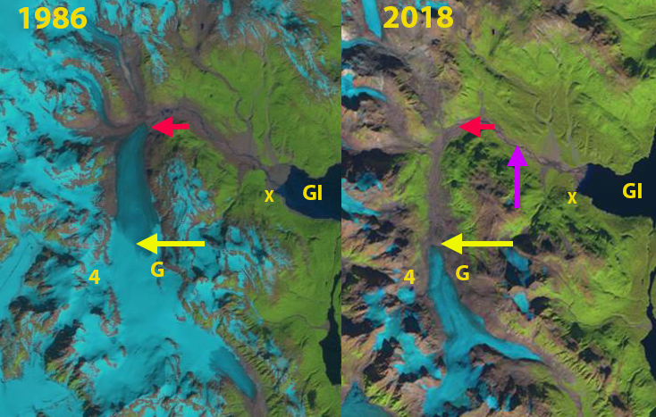
Geikie Glacier (G) in 1986 and 2018 Landsat images. Pink arrow is the 1954 terminus, red arrow the 1986 terminus and yellow arrow the 2018 terminus location. GI is Geikie Inlet which the glacier withdrew from 110 years ago.
Geikie Glacier is on the west side of Glacier Bay, Alaska. John Muir in October 1879 observed Geikie Glacier in Geikie Inlet, which had separated from Muir Glacier within the last 20 years. He wrote in John Muir Travels in Alaska, “Its lofty blue cliffs, looming through the dragged skirts of the clouds, gave a tremendous impression of savage power, while the roar of the newborn icebergs thickened and emphasized the general roar of the storm.” By 1892 when surveyed by H.F. Reid it had retreated to within several kilometers of the head of the inlet. It retreated from tidewater in ~1910 (Field, 1966), with the full inlet being 15 km in length. I had the opportunity to visit the glacier in 1982 arriving by float pane at the X at the head of the inlet. There was no glacier even in sight, where a century before was buried beneath thick glacier ice. It took us four hours to reach the terminus through what was a mixed outwash plain with developing shrubs. Today that same journey would be much more difficult as the shrubs, trees and undergrowth have thickened. William O. Field with the American Geographical Society visited Geikie Glacier in 1935, 1941, 1950 and 1958, noting limited retreat from tidewater up to 1935. though considerable frontal thinning was evident. Here we examine the changes using Landsat images from 1986, 2018 and 2019 combined with the 1961 USGS Mount Fairweather C-2 topographic map based on 1948 and 1955 photographs.
By ~1950 the glacier had retreated 2.1 km from tidewater, a rate of 50 m/year. The retreat had been interrupted by a small advance around 1920 (Field, 1966). In 1950 the glacier is fed by four tributary glaciers, with three feeding in, as the glacier makes an eastward turn. By 1986 the terminus had retreated 4.3 km from tidewater, no longer rounding the eastward bend, the retreat rate since ~1950 had been ~60 m/year. Tributaries 1-3 had separated from the glacier.
In 2014 and 2015 the glacier lost all of its snowcover (see below). In 2018 the glacier had retreated 4.1 km since 1986 and 8.3 km from the inlet. The rate had increased to ~125 m/year. Tributary 4 had separated from the glacier. The glacier shares a divide at ~600 m with a south flowing glacier and the head of the glacier is at ~1000 m. In 2014, 2015, 2018 and 2019 the entire glacier lost all of its snowcover, indicating a glacier that cannot survive, as a consistent accumulation zone is essential (Pelto, 2010). The demise of Geikie Glacier is less complete than that of nearby Burroughs Glacier, but with current climate no less certain. The glacier was ~14.5 km long when I journeyed there in 1982 and in 2018/19 is just 6.1 km long, a loss of 58% of its length in 36 years.
In 2018 and 2019 the snowlines were the highest of any year since at least 1946 on nearby Taku Glacier (Pelto, 2019) and on Brady Glacier. The rising snow lines on Brady Glacier had been observed in recent years by Pelto et al (2013). which has led to the start of a retreat. The lack of retained accumulation has also been noted at Lemon Creek Glacier and similar to Brady Glacier, Taku Glacier has now began a retreat ( McNeil et al, 2020).
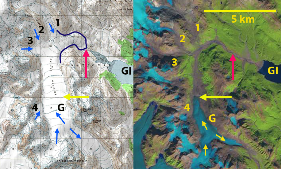
Geikie Glacier (G) in 1961 USGS map and 2019 Landsat image. Red arrow the 1986 terminus and yellow arrow the 2018 terminus location. GI is Geikie Inlet which the glacier withdrew from 110 years ago.
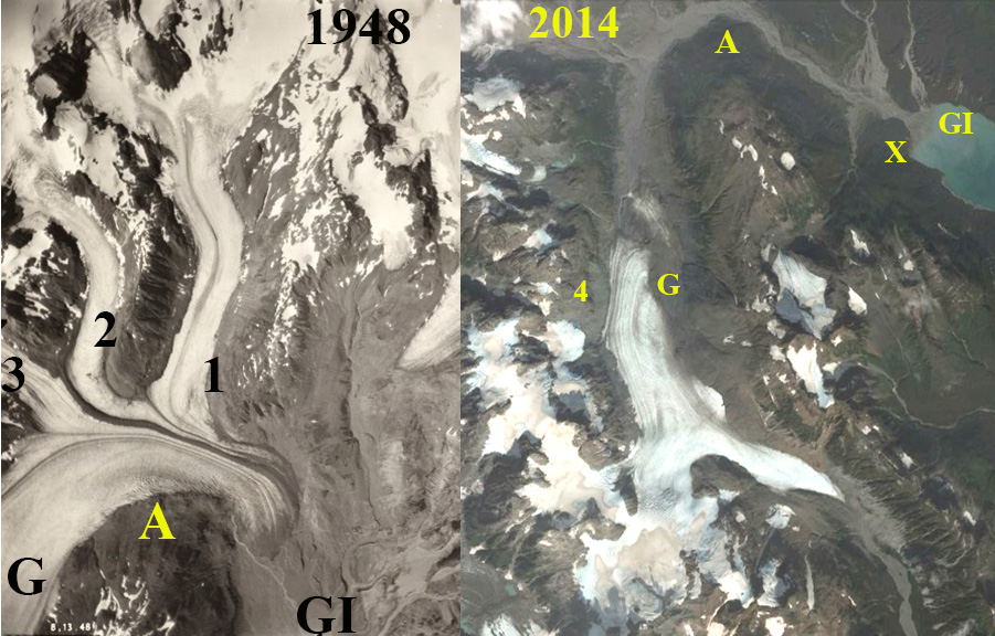
US Navy aerial photograph of Geikie Glacier terminus in 1948, tributaries 1-3 labeled. Digital Globe Image of the glacier in 2014, Point A in both is head of eastward turn.
 Dean of Academic Affairs at Nichols College and Professor of Environmental Science at Nichols College in Massachusetts since 1989. Glaciologist directing the North Cascade Glacier Climate Project since 1984. This project monitors the mass balance and behavior of more glaciers than any other in North America.