
March 12, 2021
Gorra de Nieve East Glacier, Chile Retreat-Lake Expansion
Posted by Mauri Pelto
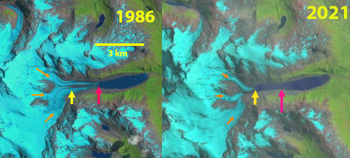
Gorra de Nieve East Glacier in 1986 and 2021 Landsat images. Red arrow is the 1986 terminus location, yellow arrow is the 2021 terminus location, orange arrows the three main tributaries.
The Gorra de Nieve massif is 50 km southwest of Monte San Lorenzo, draining its eastern flank the largest glacier of this massif is unnamed and referred to here as Gorra de Nieve East Glacier. The glacier consists of three main tributaries that join shortly above the proglacial lake the glacier has terminated in, which drains into the Rio Bravo. In this region glaciers thinned by ~0.5 m/year from 2000-2012 with most of the thinning on Gorra de Nieve East Glacier occurring on the lower sloped valley section below 1100 m (Falaschi et al 2017). The glacial history of the region is detailed in a visual map that includes moraines and trimlines including around the expanding proglacial lake discussed here Davies et al (2020). Here we examine the changes of the glacier and the expanding proglacial lake from 1986 to 2020.
In 1986 the glacier terminated in a 3 km long proglacial lake, red arrow. Three primary tributaries joined ~2 km above the terminus at 900 m, orange arrows. By 2003 the glacier has retreated ~500 m and the lateral moraines have become more prominent covering a majority of the glacier width. By 2016 the glacier has retreated ~900 m from the 1986 position and lateral moraine debris covers nearly the entire lower 1 km of the glacier. In 2021 the tributaries are separating with the northern tributary the only one feeding the terminus. The glacier has retreated 1500 m since 1986 and the proglacial lake is 4.5 km long. The two southern tributaries will separate soon and the northern tributary will also retreat from the lake.
The retreat is similar to that at San Lorenzo Sur Glacier or Calluqeuo Glacier.
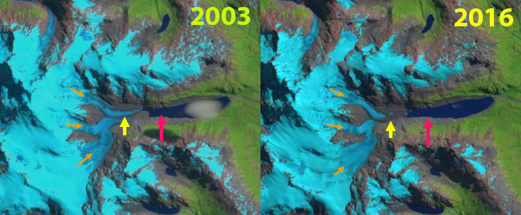
Gorra de Nieve East Glacier in 2003 and 2016 Landsat images. Red arrow is the 1986 terminus location, yellow arrow is the 2021 terminus location, orange arrows the three main tributaries.
 Dean of Academic Affairs at Nichols College and Professor of Environmental Science at Nichols College in Massachusetts since 1989. Glaciologist directing the North Cascade Glacier Climate Project since 1984. This project monitors the mass balance and behavior of more glaciers than any other in North America.