
October 16, 2020
Whiting River Headwater Glacier, British Columbia Separates into Four
Posted by Mauri Pelto
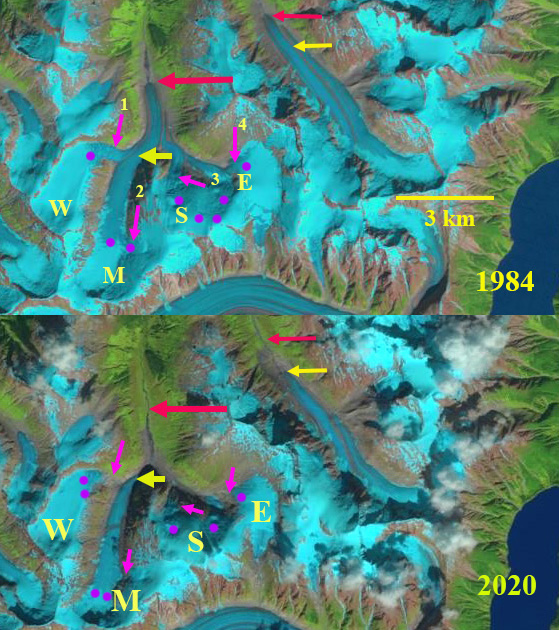
Whiting River headwaters glaciers in 1984 and 2020 Landsat images. The red arrows indicate 1984 terminus positions, yellow arrow the 2020 terminus locations, pink arrows locations of glacier detachment and purple dots the snowline.
In Northwest British Columbia on the northeast side of the Stikine Icefield the Whiting Rver drains a series of glaciers, many unnamed. Here we are focusing on a pair of glaciers just west of Whiting Lake the headwater of Whiting River, which is on the east margin of the Landsat images from 1984-2020. Glacier mass loss in the region has been extensive leading to substantial glacier recession. Melkonian et al (2016) dentified a mass loss for glaciers for Stikine Icefield of ~0.6 m year from 2000-2013 which is driving retreat.
In 1984 the four branches of the westernmost glacier: west (W), main (M), south (S) and east (E) join together at ~900 m and the glacier flows downvalley to approximately 2 km to an elevation of 700 m. The snowline is at 1250 m on the main branch. By 1999 the east branch has separated both from the south branch but also from the higher icefield at arrow #4. The snowline of the main branch is at 1300 m. By 2018 the west glacier has separated from the main branch at arrow #1, the south branch has also separated from the main branch near arrow #3. The four former tributaries are all separated. The snowline in 2018 is the highest observed at 1550 m with a very limited accumulation area less than 10%, this year was a record high for the previous 70 years at nearby Taku Glacier. By 2020 the main branch has retreated 2300 m since 1984. At arrow #2 there is a further detachment occurring from the east side accumulation are to the main branch. The eastern Whiting River Glacier has retreated 1250 m in this same period.
The retreat here is substantial in terms of the overall glacier length, and illustrates detachment as also noted for Farragut River, Alaska near the southwest corner of the Stikine Icefield. The retreat is less than that observed for the large outlet glaciers of Stikine Icefield such as South Sawyer, Dawes and Great Glacier. Whiting River is a remote and wild river that is host to six salmon species.
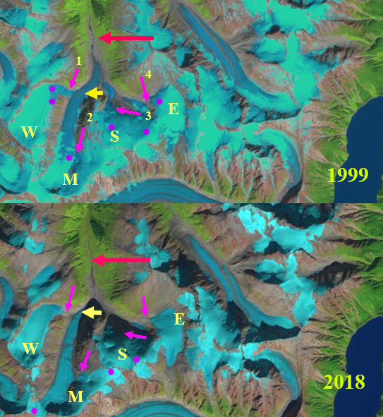
Whiting River headwaters glaciers in 1999 and 2018 Landsat images. The red arrows indicate 1984 terminus positions, yellow arrow the 2020 terminus locations, pink arrows locations of glacier detachment and purple dots the snowline.
 Dean of Academic Affairs at Nichols College and Professor of Environmental Science at Nichols College in Massachusetts since 1989. Glaciologist directing the North Cascade Glacier Climate Project since 1984. This project monitors the mass balance and behavior of more glaciers than any other in North America.
I presume these Satellite images are shown to students at mid to high school science classes… and same w: all post high school levels of study: ALL levels and numerous areas of learning..
If not… why not ?
Usually BC glacial retreat is mentioned only periodically, In this report there are three areas of notable change. Does this represent a significant trend not equaled elsewhere or is it a coincidence that three reports were submitted simultaneously?
Thank you for your detailed mapping and information. I trust you will add Joe Biden to your mailing list.
Keep healthy!
There are many BC glaciers retreating this is not a new trend. In this case Whiting, Franklin and Mount Cayley Glacier are in different portions of the Coast Mountains and have good Fall 2020 imagery that highlights the changes.