August 16, 2020
Mendeleevbreen/Øydebreen, Svalbard Terminus Retreat and Snowline Rise
Posted by Mauri Pelto
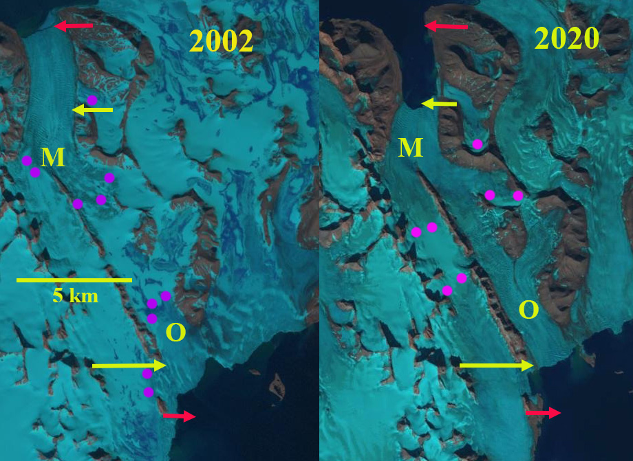
Øydebreen (O) and Mendeleevbreen (M) in 2002 and 2020 Landsat images. Red arrow is the 1990/2002 terminus, yellow arrow the 2020 terminus and purple dots the snowline.
Øydebreen and Mendeleevbreen are a pair of glaciers in Sørkapp Land, Svalbard that a share a divide. Mendeleevbreen flows north to Hornsund and Øydebreen south to Isbutka, meeting at the ice divide at 300 m. The Institute of Geophysics Polish Academy have maintained a Polish Research Station in Hornsund since 1957. The 1984 map, from the University of Silesia, of the glaciers and geomorphology document the extent of the glaciers in 1983 in the region indicating Mendeleevbreen being connected beyond the northern end of its fjord to its neighbor to the east Svalisbreen. A detailed examination by Blaszczyk, Jania and Kolondra (2013) reported the total area of the glacier cover lost in Hornsund Fjord area from 1899–2010 was approximately 172 km2. The average glacier area retreat increased from a mean of 1.6 km2/year to 3 km2/year since 2000. Pelto (2017) reported significant retreat of all 10 major tidewater glaciers of Hornsund Fjord. In the August 4, 2020 image it is apparent that one could walk from the terminus of the Mendeleevbreen over the divide to the terminus of the Øydebreen without encountering snow.
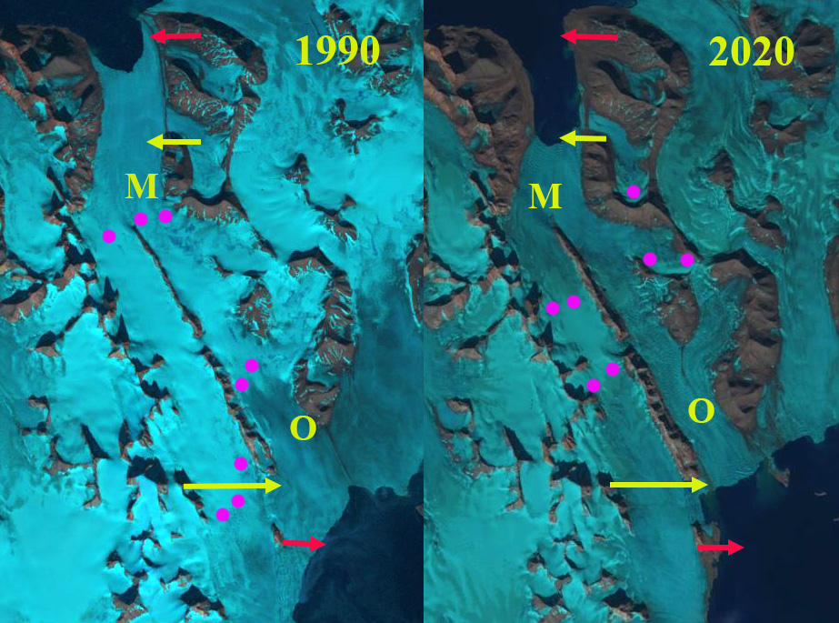
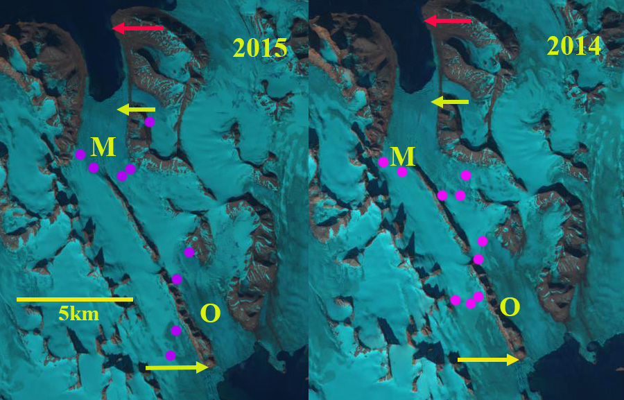
In 1990 the distance from the front of Mendeleevbreen to Øydebreen was ~17.5 km. Øydebreen terminated just east of Fallknatten, a rib of rock separating the glacier from Vasilievbreen. Mendeleevbreen terminates adjacent to a tributary from the east Signybreen. The snowline in the 1990 August Landsat image is at 200 m. By 2002 Øydebreen has retreated substantially across its entire front. Jania et al (2006) noted a 400 m advance of the center of Mendeleevbreen from 1990 to 2004. The east margin retreated and the west margin was stable during this period, with the overall front position advancing ~100 m. The glacier is known to have surged in the past, and this could have been a small surge event. The snowline in the August 2002 Landsat image is at 225 m. By 2014 the distance from the front of Mendeleevbreen to Øydebreen was 13.5 km. The Mendeleevbreen terminus had retreated to the eastern tributary of Grobreen. The snowline in August 2014 is at ~225 m. The snowline in August 2015 is at ~200 m.
By August 2020 the distance from the front of Mendeleevbreen to Øydebreen was 12.5 km, a combined retreat of 5 km since 1990. Øydebreen is now poised to retreat into its own fjord. The snowline at the start of August 2020 is above the 300-m ice divide, leaving the possibility that no snow at all will remain by the end of the melt season on either glacier. It was noted in early July how high the snowline was on Svalbard glaciers. The retreat of these two glaciers fits the pattern of Svalisbreen, Samrarinbreen and Vasilievbreen. Unfortunately the high snowlines of 2020 indicate large mass losses will occur that will only accentuate ice loss.
Øydebreen (O) and Mendeleevbreen (M) in 1990 and 2020 Landsat images. Red arrow is the 1990/2002 terminus, yellow arrow the 2020 terminus and purple dots the snowline.
Øydebreen (O) and Mendeleevbreen (M) in 2014 and 2015 Landsat images. Red arrow is the 1990/2002 terminus, yellow arrow the 2020 terminus and purple dots the snowline.
TopoSvalbard map of the region with ice flow indicated by blue arrows.


 Dean of Academic Affairs at Nichols College and Professor of Environmental Science at Nichols College in Massachusetts since 1989. Glaciologist directing the North Cascade Glacier Climate Project since 1984. This project monitors the mass balance and behavior of more glaciers than any other in North America.