June 4, 2020
Pacliash Glacier, Peru Retreat and Lake Expansion
Posted by Mauri Pelto
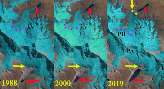
Retreat and lake expansion at Pacliash Glacier (PH) and Palcaruja Glacier in the Cordillera Blanca, Peru illustrated with 1988, 2000 and 2019 Landsat images. Red arrow is the 1988 terminus, yellow arrow the 2019, purple dots are the snowline.
Pacliash Glacier is in the Cordillera Blanca of Peru, on the northeast flank of Palcaraju and Tocllaraju had until recently terminated in Laguna Pacliashcocha. This region has seen substantial glacier retreat and area loss. Glacier lakes have increased in number and expanded during this retreat. Laguna Pacliashcocha is impounded by a glacier moraine that experienced a breach in 1997, resulting in minor GLOF in 1997 (Carey, 2010). This led to the temporary drainage of this lake over the next several years (Carey, 2010). Palmer (2019) reported on the expanding lake volume, continued GLOF hazard and engineering mitigation at the Palcacocha Lake that lies below the Palcaruja Glacier. Veettil and Kamp (2019) note a 25% decline in glacier area in the Cordillera Blanca after 1987. Here we examine the rapid retreat of the glacier and the consequent expansion of the lake and the impact on GLOF potential.
In 1988 Pacliash Glacier terminated in the lake, which had an area of 0.1 km2 and was 0.4 km long. The lowest 2 km of the glacier was heavily snowcovered and the snowline is at 5000-5100 m. In 2001 the lake had expanded to an area of 0.18 km2 and 1.0 km long, the snowline was at 5000-5100 m. By 2016 the glacier has retreated from the lake and terminated 250 m from the lake margin. The snowline is at 5300-5400 m. In 2019 the glacier terminates 300 m from the lake margin, the retreat from 1988-2019 is 1500 m. The lake is 1.25 km long and has an area of 0.28 km2 in 2019. The snowline is at 5300-5400 m, the higher snowline is the driving force behind the retreat. The smaller glacier yields less glacier runoff (Carey, 2010). This is one of many clear examples of glacier watershed fed hydrologic systems and the connected social systems in the Andes being transformed by global change (Mark et al, 2017).
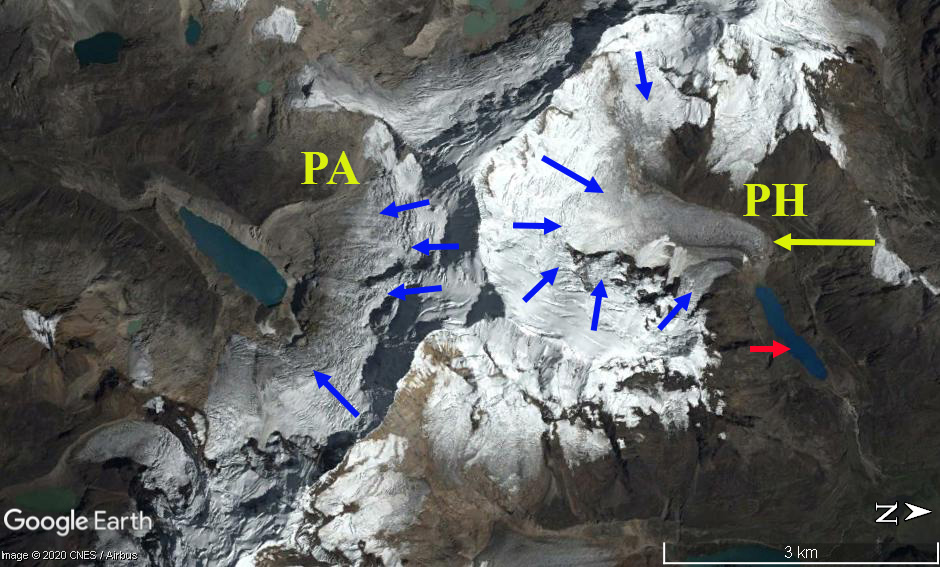
The GLOF threat in this case has declined as the glacier has receded from the lake and is ending on a slope that is not steep enough to easily have an avalanche travel across/from the glacier to the lake. Palcaruja Glacier has experienced a similar retreat and lake expansion, but has a much steeper slope from the terminus to the lake, hence the avalanche risk into the lake generating a GLOF remains high (Palmer, 2019). Emmer et al (2016) notes that the number of GLOF’s were greater from moraine dammed lakes in the region early in the retreat phase in the 1940’s and 1950’s. This suggest the moraines are becoming more stable with time since formation and glacier retreat.
Digital Globe image of Pacliash and Palcaruja Glacier in 2016, red arrow is the 1988 and yellow arrow the 2019 terminus. Blue arrows show glacier flow direction.


 Dean of Academic Affairs at Nichols College and Professor of Environmental Science at Nichols College in Massachusetts since 1989. Glaciologist directing the North Cascade Glacier Climate Project since 1984. This project monitors the mass balance and behavior of more glaciers than any other in North America.