
January 6, 2020
Sona and Meola Glacier Retreat Dhauliganga Basin, India
Posted by Mauri Pelto
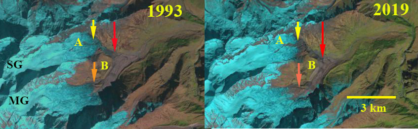
Sona Glacier (SG) and Meola Glacier (MG) in 1993 and 2019 Landsat images. Red arrow indicates 1993 terminus location of Sona Glacier and Yellow arrow the 2019 terminus location. The orange arrow marks the 1993 downglacier limit of clean ice, below is debris covered ice. Point A marks a small expanding rock outcrop amidst glacier. Point B marks north lateral moraine exposure of Meola Glacier.
The Dhauliganga River is in the Uttarakhand District, India and is fed by a significant number of large glaciers. The glacier runoff is a significant contributor to streamflow for the Dhauliganga Power Station 280 MW run of river hydropower. The reservoir is only 1 km long. Sattar et al (2019) examined glacier volume and velocity of 15 large glaciers in the basin and found a 6.9% loss in area from 1968-2016. The velocity tends to be highest in the upper ablation zone and declines toward the debris covered terminus regions. Here we utilize Landsat imagery from 1993-2019 to focus on two glaciers Sona and Meola Glacier that were previously joined in Survey of India map (NH-44-06).
In the map below Sona Glacier and Meola Glacier are joined near Point B. In 1993 and 1994 Sona Glacier descends a steep slope terminating at the red arrow a short distance from Meola Glacier. At Point A the rock outcrop is minor. At Point B the lateral moraine slope above the glacier surface is limited. By 2016 Sona Glacier has retreated to the top of the steep slope. The orange arrow indicates clean ice on Meola Glacier has retreated upwards. By 2019 Point A has expanded and is now a ridge separating the glacier into two terminus tongues. Sona Glacier has retreated 1200 m from 1993-2019. The retreat was enhanced by the steep slope that the thin terminus descended in 1993. At Point B the lateral moraine slope above the glacier surface is notably larger indicating Meola Glacier thinning. The debris cover/clean ice transition on Meola Glacier has moved 600 m upglacier.
The retreat of the Sona Glacier and expansion of debris cover indicate the expansion of ablation zones that is also seen at nearby Khatling Glacier, Gangotri Glacier and Ratangrian Glacier.
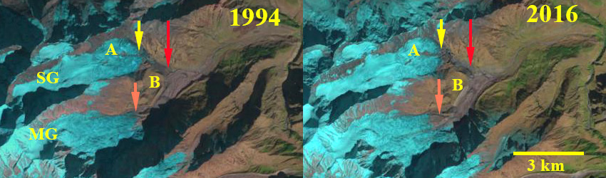
Sona Glacier (SG) and Meola Glacier (MG) in 1994 and 2016 Landsat images. Red arrow indicates 1993 terminus location of Sona Glacier and Yellow arrow the 2019 terminus location. The orange arrow marks the 1993 downglacier limit of clean ice, below is debris covered ice. Point A marks a small expanding rock outcrop amidst glacier. Point B marks north lateral moraine exposure of Meola Glacier.

Map indicating Sona Glacier (SG) and Meola Glacier (MG) draining into the Dhauliganga.
 Dean of Academic Affairs at Nichols College and Professor of Environmental Science at Nichols College in Massachusetts since 1989. Glaciologist directing the North Cascade Glacier Climate Project since 1984. This project monitors the mass balance and behavior of more glaciers than any other in North America.
[…] Fonte/Source: https://blogs.agu.org/fromaglaciersperspective/2020/01/06/sona-and-meola-glacier-retreat-dhauliganga… […]