November 10, 2019
Shie Glacier, Bhutan-China Retreat Reduces Lake Contact
Posted by Mauri Pelto
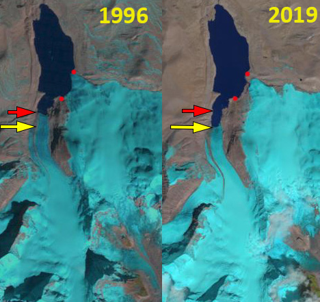
Shie Glacier Bhutan-China in Landsat images from 1996 and 2019. Red arrow is the southern terminus location in 1996, yellow arrow the 2019 terminus location and red dots the margin of the eastern terminus in contact with the lake in 1996.
Shie Glacier terminates in a lake on the northern flank of the Bhutan Himalaya draining north from Kangphu Kang, in a region that is claimed by both China and Bhutan. Here we examine 1996-2019 Landsat imagery to identify glacier change. Bajracharya et al (2014) reported a 23% loss in glacier area from 1980-2010. This retreat led to a 20% increase in the number of glacier lakes in the region (Che et al, 2014)
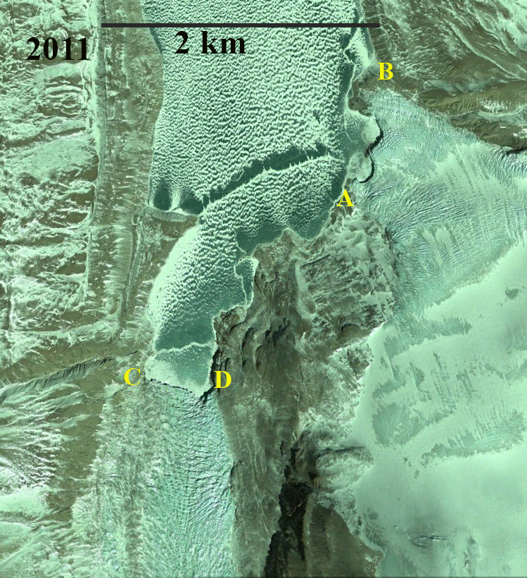
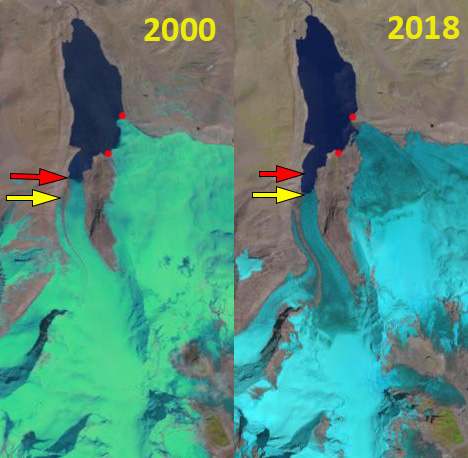
In 1996 the glacier had two prominent termini ending the lake. The eastern terminus had a 1300 m wide front in the lake and the southern terminus a 400 m wide front. The southern are terminated 800 m up a narrow inlet. In 2000 there was a minor retreat of less than 100 m of both terminus locations since 1996. in 2011 both glaciers had an active calving front in the lake, with the eastern terminus, between Point A and B, reduced to 800 m of front in contact with the lake. The southern terminus between Point C and D has retreated 350-400 m since 1996.
By 2018 the southern terminus had retreated 600 m further up the inlet. In 2018 the eastern glacier front reached the lake on a front less than 100 m wide. In 2019 the eastern terminus does not reach the lake on a measurable front. The eastern terminus has retreated 400 m on the northern margin, 350 m in the glacier center and 800 m on the southern margin. The southern terminus has retreated 700-800 m since 1996. The reduced connection of the glacier to this lake will alter the nutrient flux to the lake. The lake has had a consistent water level during the entire period and the terminal moraine that helps impound the lake is deeply incised. The combination along with reduced frontal suggests the GLOF threat is low
High snowlines in recent years will continue to drive retreat here and on adjacent Theri Kang and Lugge Glacier.
2011 Digital Globe image of Shie Glacier terminus, eastern terminus between Point A and B, southern terminus between Point C and D.
Shie Glacier Bhutan-China in Landsat images from 2000 and 2018. Red arrow is the southern terminus location in 1996, yellow arrow the 2019 terminus location and red dots the margin of the eastern terminus in contact with the lake in 1996.


 Dean of Academic Affairs at Nichols College and Professor of Environmental Science at Nichols College in Massachusetts since 1989. Glaciologist directing the North Cascade Glacier Climate Project since 1984. This project monitors the mass balance and behavior of more glaciers than any other in North America.
[…] Fonte/Source: https://blogs.agu.org/fromaglaciersperspective/2019/11/10/shie-glacier-bhutan-china-retreat-redcues-… […]