
September 9, 2019
Retreat of West Barun Glacier and Barun Tsho expansion, Nepal 1994-2018
Posted by Mauri Pelto
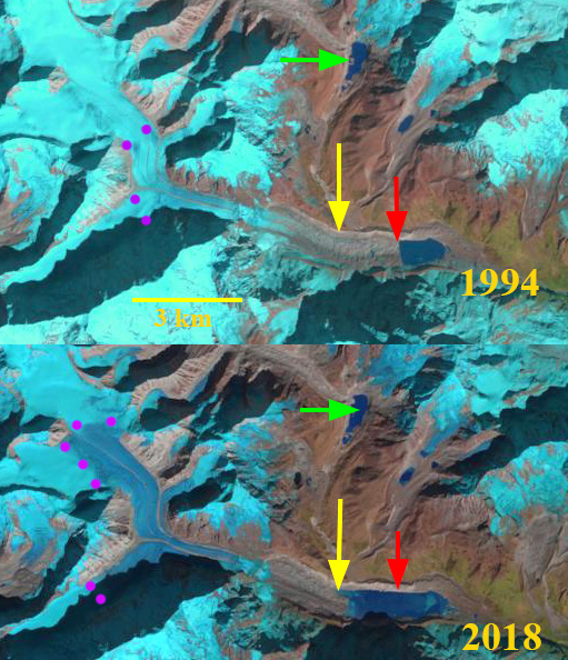
West Barun Glacier terminus retreat and lake expansion in 1994 and 2018 Landsat images. Red arrow is the 1994 terminus location, yellow arrow the 2018 terminus location, green arrow Seto Pohkari and purple dots the snowline.
The West Barun Glacier flows southwest from Baruntse Peak at 7100 meters ending at Lower Barun Tsho (Barun Tsho) at 4500 meters. Comparison of Landsat images from 1994, 2000, 2015 and 2019 indicate the retreat of the glacier and expansion of the lake. In the early 1990’s the lake was observed to have an area of 0.7 km2 (ICIMOD, 2010). The importance of such lakes impounded in part by moraines, is the potential for glacier lake outburst floods (GLOF). The Lower Barun Tsho has no specific date for a GLOF observed. Rounce et al (2017) examined the risk posed by Lower Barun Tsho, part of which is another proglacial lake 3 km upstream, Seto Pohkari with an area of 0.41 km2 and it is considered to be a high hazard as the avalanche. There are 33 buildings, 4 bridges and ~0-.8 km2 of agricultural land at risk of GLOF damage below Lower Barun Tsho (Rounce et al 2017) .
In 1994 the lake is 1100 m long and has an area of ~0.6 km2. By 2000 the lake was 1400 meters long and the area has increased to 0.9 km2. The snowline in both 1994 and 2000 is ~5700 m. In 2009 the lake was 2000 meters long and had an area of 1.4 km2 having doubled in size. By 2015 the lake is 2700 m long and has an area of ~1.6 km2. Haritashya et al (2018) surveyed Lower Barun Tsho in 2015 and found a maximum depth of 205 m and a volume of 112.3 × 10⁶ m3. In 2018 the maximum length of the lake is 2800 m and the area 1.7 to 1.8 km2. The snowline in 2015 and 2018 is at 6000 m, which is above the mean elevation of the glacier, indicating mass balance loss. In the 2009 Digital Globe imagery below, right half of image, the glacier is stagnant below the light green arrow. The medial moraines evident at the purple arrows indicate the area around 5700-5800 m that typically is in the ablation zone. The orange arrows indicate the outflow from Seto Pohkari. The dark green arrows indicate the wide moraine band. There is some melt out of this 1 km wide band resulting in lake expansion and pond development. The lake length and area has doubled since 2000. Glacier retreat has been 1500 m from 1994-2018. Haritashya et al (2018) expect faster growth and increasing risk from Lower Barun Tsho. The beginning of a stagnant zone below the icefall, light green arrow below, indicates rapid retreat can continue. The changes here are repeated at many glaciers in this region including Lumding, Lhonak, Yanong and Thulagi
Kirschbaum et al (2019) examined the cascade of hazard impacts that can work together to generate or accentuate geologic hazards in this regions including earthquakes, monsoon flood events, avalanches and GLOFs.
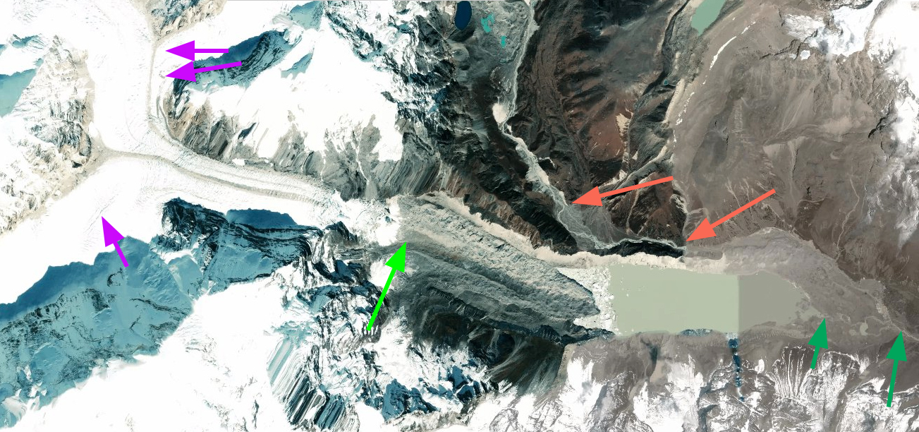
West Barun Glacier: Purple arrows indicate upper reach of lateral moraines, light green arrow the start of the stagnant zone below an icefall, orange arrows indicate the river draining the Seto Pohkari and dark green arrows indicate the partially ice cored moraine belt.
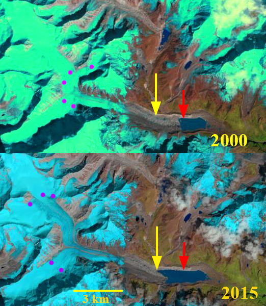
West Barun Glacier terminus retreat and lake expansion in 2000 and 2015 Landsat images. Red arrow is the 1994 terminus location, yellow arrow the 2018 terminus location, green arrow Seto Pohkari and purple dots the snowline.
 Dean of Academic Affairs at Nichols College and Professor of Environmental Science at Nichols College in Massachusetts since 1989. Glaciologist directing the North Cascade Glacier Climate Project since 1984. This project monitors the mass balance and behavior of more glaciers than any other in North America.