May 28, 2019
Sulmeneva Bay Glacier Retreat 1990-2018, Novaya Zemlya
Posted by Mauri Pelto
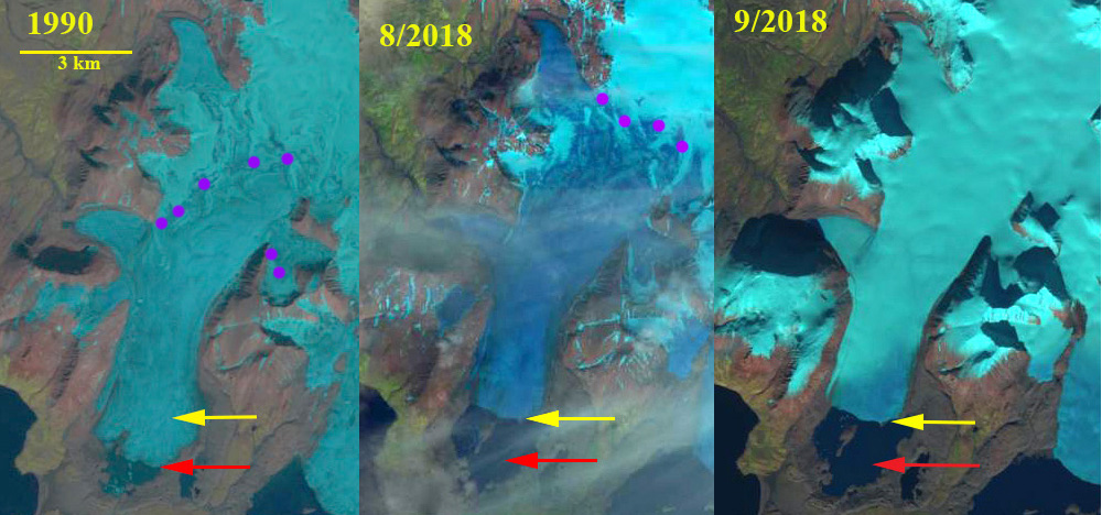
Sulmeneva Bay Glacier in Landsat images from 1990 and 2018. Red arrow is the 1990 terminus location, yellow arrow the 2018 terminus location and pink dots the snowline.
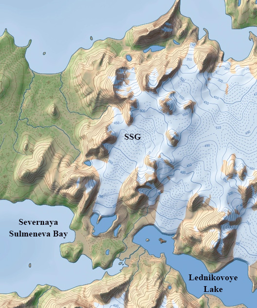
Here we examine an unnamed glaciers, referred to here as Sulmeneva Bay Glacier, that terminated in a piedmont lobe near the northern shore of Sulmeneva Bay and just east of Lednikovoye Lake in central Novaya Zemlya. Sulmeneva Bay is on the west coast of Novaya Zemlya and is the southern most extent of the continuous glaciation that extends along the northern half of the island. LEGOS (2006) identified a 1.24 km2 reduction in area of this glacier from 1990-2000. Carr et al (2014) identified an average retreat rate of 52 meters/year for tidewater glaciers on Novaya Zemlya from 1992 to 2010 and 5 meters/year for land terminating glaciers. The glacier is retreating like all tidewater glaciers in northern Novaya Zemlya, though they are not specifically tidewater the lake terminating glaciers were retreating at a similar rate of ~40 m/year from 1986-2015 (Carr et al., 2017). Here we use Landsat images to examine changes from 1990 to 2018.
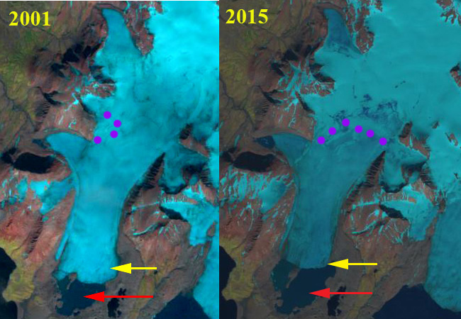
In 1990 Sulmeneva Bay Glacier terminates in a proglacial lake at the southern end of what will become an island in the lake. The lake is 1.1 km wide from the calving front to the southern shore, red arrow. The snowline in 1990 is at 550 m, while the head of the glacier is at 650 m. By 2001 the glacier has retreated 700 m and the snowline is at 600 m reaching the ice divide in some areas. In 2015 the snowline is at 400 m and the lake has continued to expand with a north-south reach of 1.7 km. The glacier terminates at the northern end of the developing island.
In August of 2018 the snowline is at 550 m, again leaving a limited accumulation zone. By mid-September snowfall has lowered the snowline back to 200 m. The glacier has now retreated from the central island in the proglacial lake. This should lead to an increase in calving. The glacier has retreated 1.2 km since 1990 and the lake is now 2.2 km from the calving front to the southern shore.
The retreat here is similar to the glaciers of Lednikovoye Lake and to Sulmeneva Glacier which retreated less, but across a broader front. What is evident is that the persistent high snowlines are leading to negative mass balances that will drive continued retreat. At Lednikovoye Lake high snowlines in 2000 and 2016 further indicate the spatial extent and temporal frequency of high snowlines in recent years.
Sulmeneva Bay Glacier in Landsat images from 2010 and 2015. Red arrow is the 1990 terminus location, yellow arrow the 2018 terminus location and pink dots the snowline.
Novaya Zemlya map produced by Christoph Hormann with Sulmeneva Bay Glacier (SSG) shown just west of Lednikovoye Lake.


 Dean of Academic Affairs at Nichols College and Professor of Environmental Science at Nichols College in Massachusetts since 1989. Glaciologist directing the North Cascade Glacier Climate Project since 1984. This project monitors the mass balance and behavior of more glaciers than any other in North America.