
April 1, 2019
Nakonake Glaciers, BC Retreat Two are Disappearing
Posted by Mauri Pelto
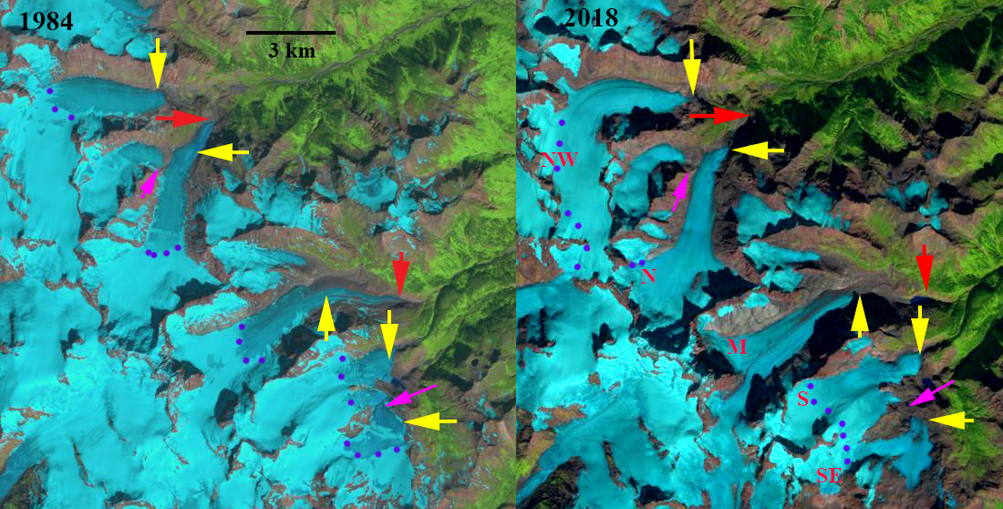
Nakonake Glaciers in 1984 and 2018 Landsat images. Nakonake Glaciers are NW=Northwest, N=North, M=Middle, S=South, SE=Southeast. Red arrows indicate the 1984 terminus position of the North and Middle Nakonake Glaciers. Yellow arrows indicate the 2018 terminus location of each. Purple dots indicate the snowline and the pink arrow indicates locations of glacier separation.
The Nakonake Glaciers are a group of unnamed glaciers at the headwaters of the Nakonake River in NW Britishc Columbia. The range is just east of the Tulsequah Glacier-Juneau Icefield. The Nakonake River flows into the Sloko River which joins the Taku River. There are sockeye, coho and chinook salmon in the Sloko River. The Sloko River below the junction with Nakonake River is known as a fun stretch of river to run. My only experience with this glacier group was watching a grizzly bear ascend from the lower Tulsequah Glacier into the Nakonake area. Menounos et al (2018) indicate this region of British Columbia had the largest mean annual mass balance losses from 2000-2018.
In 1984 the Norhtwest (NW) Nakonake terminated at the top of a steep slope at 1100 m. North (N) Nakonake Glacier terminated at 800 m with a longer valley tongue than the NW glacier. The Middle (M) Nakonake Glacier terminated at 900 m and had a substantial low slope terminus tongue. The South (S) Nakonak Glacier merged with the Southeast (SE) Nakonake Glacier at this time. The snowline varied from 1500 m on NW to 1400 m on N and M and 1300 m on S and SE. By 1999 the SE Nakonake Glacier had separated from the S Nakonake Glacier though it still had two terminus lobes that were connected. The snowline ranged from 1600 m on the NW Nakonake to 1400 m on the S and SE Nakonake. In 2017 the snowline was quite high ranging from 1700+ m on NW Nakonake to 1500+ m on South Nakonake Glacier. In 2018 the Juneau Icefield regions saw the highest snowlines of the last 70 years (Pelto, 2018). The snowline was above the top of the M Nakonake and SE Nakonake Glacier. The snowline was above 1800 m on NW Nakonake and 1700 m on the S Nakonake Glacier. Retreat of the NW Nakonake from 1984-2018 was limited at 200 m, though recent high snowlines should accelerate this retreat. The N Nakonake Glacier that had a low elevation terminus tongue still in 1984 and retreated 1400 m from 1984-2018. The M Nakonake also had a low elevation tongue that melted away leading to a retreat of 2200 m from 1984-2018. The retreat is 30+% of the glacier length lost. This glacier lacks a significant accumulation and will not survive. The S Nakonake retreat like the NW was minor at ~200m. The SE Nakonake Glacier was 700 m, which given a glacier length of just over 3 km is a substantial loss. This glacier lacks a significant accumulation zone and will not survive. This glacier has separated into two parts.
Tulsequah Glacier has experienced a more rapid retreat enhanced by proglacial lake development (Pelto, 2017).

Nakonake Glaciers in 1999 and 2017 Landsat images. Nakonake Glaciers are NW=Northwest, N=North, M=Middle, S=South, SE=Southeast. Red arrows indicate the 1984 terminus position of the North and Middle Nakonake Glaciers. Yellow arrows indicate the 2018 terminus location of each. Purple dots indicate the snowline.
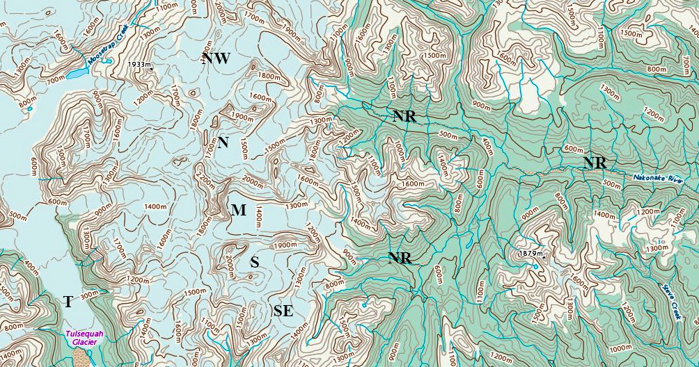
Map of the Nakonake Glaciers and headwaters of the Nakonake River (NR). Tulsequah Glacier (T) to the west is also noted.
 Dean of Academic Affairs at Nichols College and Professor of Environmental Science at Nichols College in Massachusetts since 1989. Glaciologist directing the North Cascade Glacier Climate Project since 1984. This project monitors the mass balance and behavior of more glaciers than any other in North America.