
March 18, 2019
Soranano Glacier, Peru Separation and Retreat 1995-2018
Posted by Mauri Pelto

Western Soranano (WS) and Eastern Soranano Glacier (ES) in 1995 and 2000 Landsat images and 2018 Sentinel image, with red arrows indicating the terminus in 1995, and yellow arrows the 2018 terminus.
Here we examine the west and east Soranano Glacier glacier descending south from the 5800 m summit of Jatunnano (Hatun Nana Punta). The glaciers are just east of Laguna Sibinacocha, which drains into the Rio Vilcanota. Retreat of glaciers in the Cordillera Vilcanota, Peru has been rapid since 1975, Veettil et al (2017) noted that ~80% of glaciated area below 5000 m was lost from 1975-2015 and glacier area overall declined 48%. Henshaw and Bookhagen (2014) observed that from 1988-2010 glacial areas in the Cordillera Vilcanota had been declining annually by ~4 km2, which is just over 1% per year for this region that had a glacial area of 361 km2 in 1988.
In 1995 the western Soranano Glacier terminates in a proglacial lake at 5000 m the eastern glacier terminates just north of Laguna Soranano also at ~5000 m. Point A is encircled by the two lobes of the western Soranano Glacier. By 2000 there is minor retreat of both glaciers. By 2018 the western Soranano Glacier has separated into two lobes, with the former rock knob at Point A now the separating rib. The glacier has retreated 800 m since 1995, which is 20% of its 4 km length in 1995. The eastern Soranano Glacier has retreated 700 m and has also separated into two lobes. A new small lake has formed in front of the western lobe.
The formation of new lakes and the retreat from proglacial lakes has been a common occurrence in recent decades for Andean glaciers in Peru such as Manon Glacier , Safuna and Arhuey Glacier. The key role of glaciers to runoff is illustrated by the fact that 77% of lakes connected to a glacier watershed have maintained the same area or expanded, while 42% of lakes not connected to a glacier watershed have declined in area Henshaw and Bookhagen (2014). Laguna Sibinacocha water level is raised by the Sibinacocha Dam, to maintain the flow of the Vilcanota River in dry season and support the normal operation of the Machupicchu Hydroelectric Power Plant managed by EGEMSA, which has an operating capacity of 90 MW. The Vilcanota River becomes the Urubamba River further downstream.
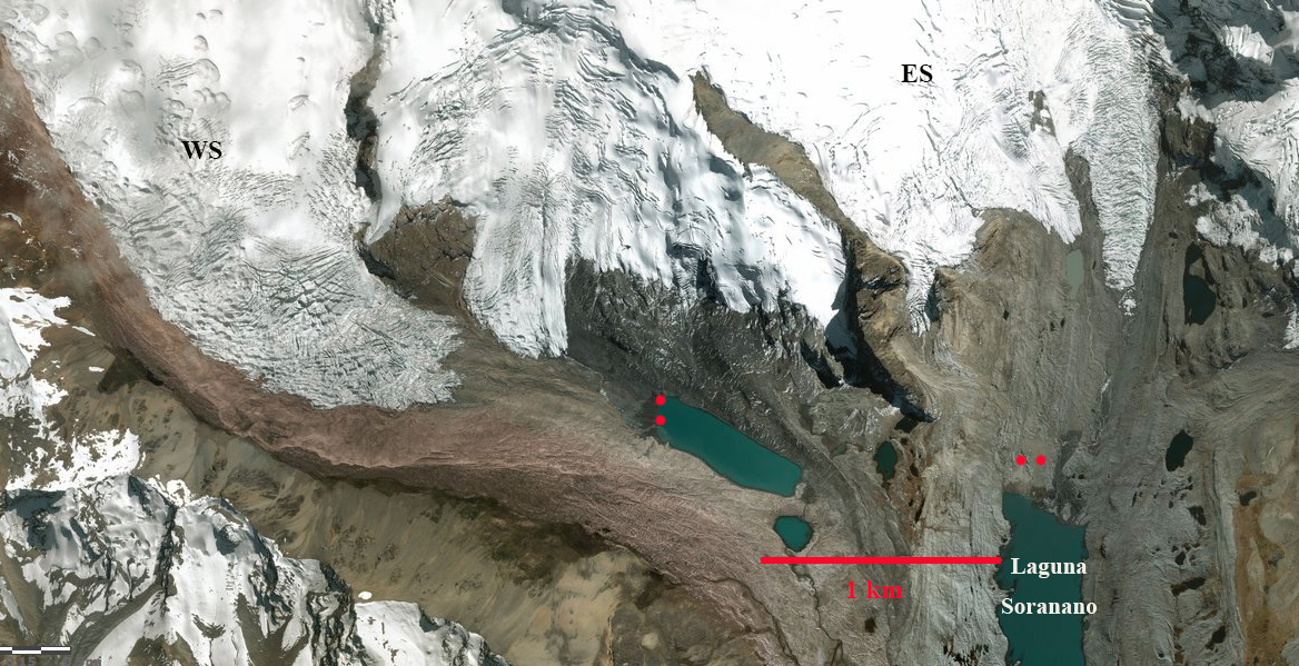
Western Soranano (WS) and Eastern Soranano Glacier (ES), with red dots indicating the terminus in 1995, this is a 2018 Digital Globe image.

Western Soranano and Eastern Soranano Glacier, with red arrows indicating the terminus in 1995, and yellow arrows the 2018 terminus in this 2018 Digital Globe image.

Trekking map of the region, red arrows indicate the Soranano Glaciers
 Dean of Academic Affairs at Nichols College and Professor of Environmental Science at Nichols College in Massachusetts since 1989. Glaciologist directing the North Cascade Glacier Climate Project since 1984. This project monitors the mass balance and behavior of more glaciers than any other in North America.