
January 20, 2019
Novosilski Glacier, South Georgia 2.5 km Retreat 2001-2018
Posted by Mauri Pelto
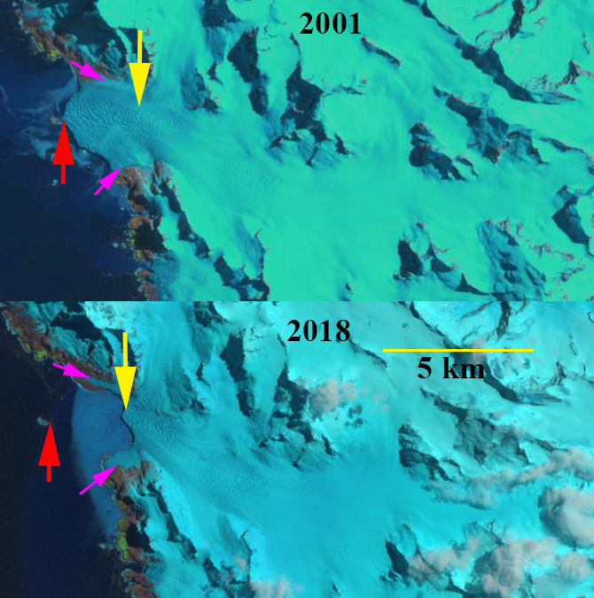
Novosilski Glacier in Landsat images from 2001 and 2018. Red arrow indicates 2001 terminus location, yellow arrow the 2018 terminus location, pink arrows the fringing grounded sections of marginal ice.
Novosilski Glacier is a large tidewater outlet glacier on the west (cloudier) coast of South Georgia terminating in Novosilski Bay It shares a divide with the rapidly retreating Ross and Hindle Glacier on the east coast. Gordon et al. (2008) observed that larger tidewater and calving outlet glaciers generally remained in relatively advanced positions from the 1950’s until the 1980s. After 1980 most glaciers receded; some of these retreats have been dramatic. The change in glacier termini position have been documented by Cook et al (2010) at British Antarctic Survey in a BAS retreat map, identified that 212 of the Peninsula’s 244 marine glaciers have retreated over the past 50 years and rates of retreat are increasing. Pelto (2017) documented the retreat of 11 of these glaciers during the 1989-2015 period. Here we examine Landsat images from 2001-2018 and the British Antarctic Survey GIS of the island to identify the magnitude of glacier change.
In 2001 Novosilski Glacier terminated in shallow water just east of a small island that acted as a pinning point, red arrow. By 2009 the glacier had retreated only a minor amount from this island into deeper water. A rapid retreat ensued and by 2016 the glacier had retreated into a narrower fjord reach. The north and south margins featured remanant ice that was based above tidewater, pink arrows. The blue arrows in the 2016 Landsat image indicating the large accumulation area feeding Novosilski. By 2018 the 2 km wide calving front had retreated 2.5 km from the 2001 position. There is little evident thinning upglacier of the terminus and, there is a significant increase in surface slope suggesting that unless calving rate increases, the terminus can remain near its current position. The snowline is low below 500 m in each of the satellite images of the glacier. This is not a particularly hospitable section of coastline and the BAS has only identified Gentoo Penguins having colonies in the area.
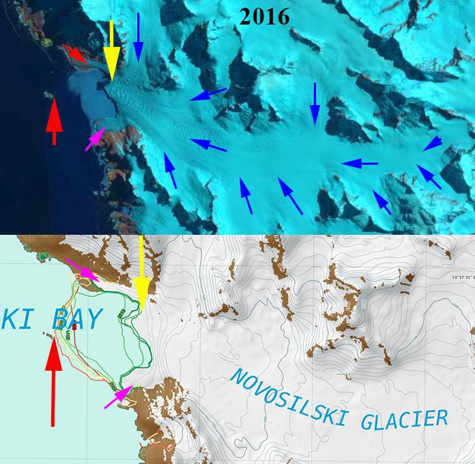
Novosilski Glacier in Landsat image from 2016. Red arrow indicates 2001 terminus location, yellow arrow the 2018 terminus location, pink arrows the fringing grounded sections of marginal ice, and blue arrows the glacier flow directions. Below is the South Georgia BAS map of the area indicating glacier margin position and elevation contours.

Novosilski Glacier in Landsat image from 2009. Red arrow indicates 2001 terminus location and, yellow arrow the 2018 terminus location.
 Dean of Academic Affairs at Nichols College and Professor of Environmental Science at Nichols College in Massachusetts since 1989. Glaciologist directing the North Cascade Glacier Climate Project since 1984. This project monitors the mass balance and behavior of more glaciers than any other in North America.