January 2, 2019
Chaba Glacier, Alberta Retreat and Icefall Separation
Posted by Mauri Pelto
Chaba Glacier in 1986 and 2018 Landsat images. Red arrow is 1986 terminus location, yellow arrow 2018 terminus location, pink arrows bedrock steps in icefall area, orange arrow, adjacent glacier and purple dots the snowline.
Chaba Glacier is a valley glacier descending from the Chaba-Clemenceau Icefield ending in the headwaters regions of the Athabasca River in Alberta. Jiskoot et al (2009) examined the behavior of the Clemenceau Chaba Icefield and found that from the mid 1980’s to 2001 the Clemenceau Icefield glaciers had lost 42 square kilometers, or 14% of their area. During this same period terminus retreat averaged 21 meters per year on the glaciers. A short distance to the southeast is the better known Columbia Icefield. Tennant and Menounos (2013) examined changes in the Columbia Icefield 1919-2009 and found a mean retreat of 1150 m and mean thinning of 49 m for glaciers of the icefield, with the fastest rate of loss from 2000-2009. Here we examine the changes of Chaba Glacier from 1986-2018 using Landsat images.
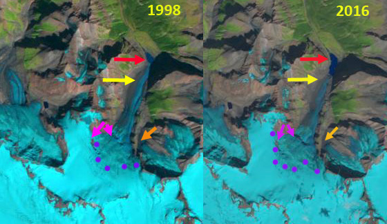
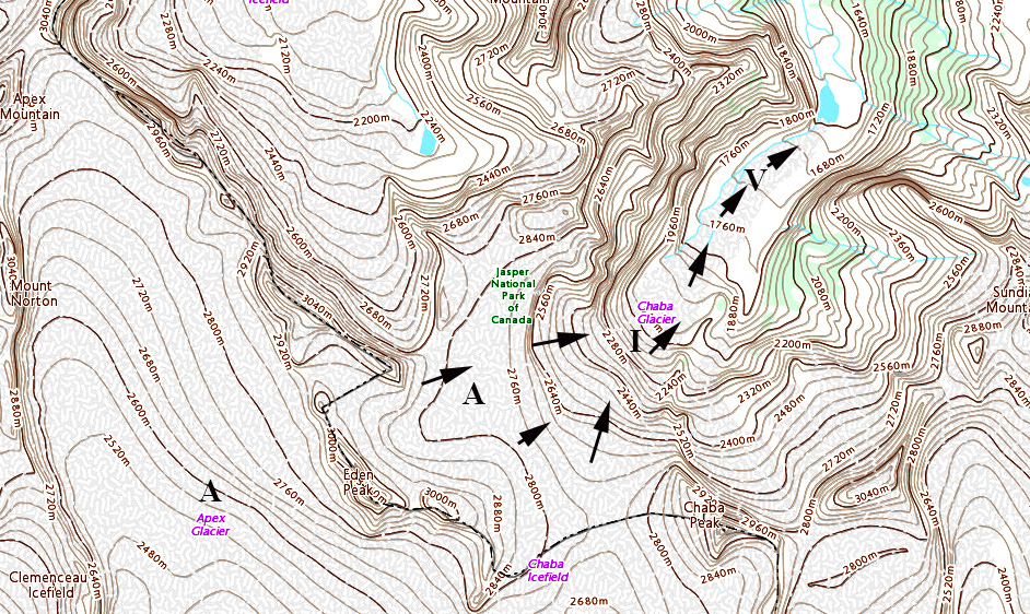
Chaba Glacier has a substantial accumulation zone above 2600 m in the upper basin, the glacier then flows down an icefall from 2600 m to 2000m where it levels off in a lower slope valley tongue. In 1986 Chaba Glacier terminated in a 200 m wide proglacial lake at 1600 m, red arrow. The valley tongue below the icefall was 3.5 km long. The icefall featured one exposure of rock at the pink arrow on the right. The snowline in 1986 is at ~2500 m. The orange arrow indicates a separate glacier that flows down an icefall into the valley below and almost connects with Chaba Glacier. In 1988 the snowline is lower at ~2450 m the proglacial lake. In 1998 the glacier has retreated 200 m, leading to lake expansion. The snowline is at ~2550 m and only the upper bedrock rib is evident in the icefall, pink arrow. By 2016 the proglacial lake has doubled in size. The adjacent glacier that had terminated at the orange arrow, no longer descends below the icefall into the valley. The lower bedrock rib in the icefall is now evident, right pink arrow. The snowline is above ~2600 m, with a month left in the melt season. JuSt across the divide in the Columbia River Basin, measurements by Ben Pelto of UNBC, indicated negative mass balance from 2014-2018 on glaciers in the northern portion of the basin closer to Chaba Glacier. In 2018 the proglacial lake is 900 m across and the glacier no longer terminates in the lake. This Aug. 20 2018 image indicates the snowline is at ~2650 m. The developing step in the icefall, right pink arrow at 2200 m, indicates a lack of strong flow through the icefall to the valley tongue, this will accelerate downwasting of the valley tongue. Retreat from 1986-2018 is ~900 m. The valley tongue has narrowed at its 1986 halfway point, from the icefall to the terminus, from 700 m to 400 m. Chaba Glacier has experienced similar retreat to the adjacent Apex Glacier that experienced a retreat of 800 m from 1986-2010. Cummins Glacier retreated 500 m from 1986-2015, but also fragmented from adjacent glaciers. A short distance southeast, Columbia Glacier an outlet of Columbia Icefield retreated 3000 m from 1986-2015> the rapid rate of retreat is more than three times as fast relative to the Chaba, due to mass loss through ice calving in the large proglacial lake at the terminus.
Chaba Glacier in 1998 and 2016 Landsat images. Red arrow is 1986 terminus location, yellow arrow 2018 terminus location, pink arrows bedrock steps in icefall area, orange arrow, adjacent glacier and purple dots the snowline.
Canadian Topographic map of the Chaba Glacier area, the accumulation zone=A, icefall=I and valley tongue=V, with flow arrows. The map is from ~1990.


 Dean of Academic Affairs at Nichols College and Professor of Environmental Science at Nichols College in Massachusetts since 1989. Glaciologist directing the North Cascade Glacier Climate Project since 1984. This project monitors the mass balance and behavior of more glaciers than any other in North America.