
November 2, 2018
Breney Glacier Switzerland Accelerating Retreat 1988-2018
Posted by Mauri Pelto
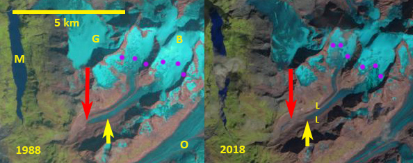
Breney Galcier, Switzerland in Landsat images from 1988 and 2018. Red arrow = 1988 terminus location, yellow terminus =2018 and purple dots the snowline. B=Breney Glacier, G=Gietro Glacier, L=Lateral Moraine, M=Lac Mauvoisin and O=Otemma Glacier.
Breney Glacier (B) is in the next valley to the north of Otemma Glacier (O) and south of Gietro Glacier (G), it flows southwest into Lac de Mauvoisin (M). Breney Glacier is one of the glaciers where the terminus is monitored annually by the Swiss Glacier Monitoring Network (GLAMOS:VAW/ETH). Here we examine changes in this glacier from 1988 to 2018 including changes in the terminus using Landsat Imagery. GLAMOS:VAW/ETH reports that Breney Glacier retreated 175 m from 1988-1999, and a further 625 m from 1999-2015. The Mauvoisin Dam can produce 363 MW of power, and typically provides 1030 millionKWh of power each year. The reservoir can store 200 million cubic meters of water.
Here we examine Landsat images to identify changes in this glacier during the last three decades 1988-2018. In 1988 the glacier extended onto an outwash plain at 2600 m and the snowline was at 3300 m. In 1999 the snowline is at 3200 m, the terminus has experienced limited retreat across the low slope outwash plain. By 2015 the terminus has retreated to ~2700 m, the snowline is at 3500 m. In 2018 the snowline is at 3500-3600 m too high to sustain the glacier at its current length. The glacier has retreated from the outwash plain that is still accumulating sediment. There is significant retreat from 2015 to 2018, more than 100 m. There are regions of ice cored moraine (ICM). The current lateral moraine that is visible on both margins of the glacier illustrates the recent rapid thinning and the insulating effect of the debris. There is limited crevassing on the lower glacier which is dissected by a supraglacial stream, note detailed Google Earth image below. The northern arm of Breney is Serpentine Glacier, which is thinning and appears close to separation from Breney Glacier. The retreat is similar in magnitude to adjacent Otemma Glacier (O) and south of Gietro Glacier (G), all driven by high glacier melt and the resulting high snowlines. The mass balance of Swiss Glaciers has had a sustained strongly negative trend since 2003 (Huss et al 2015).
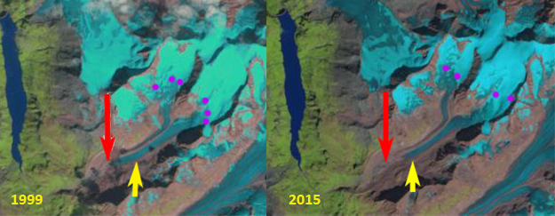
Breney Galcier, Switzerland in Landsat images from 1988 and 2018. Red arrow = 1988 terminus location, yellow terminus =2018 and purple dots the snowline.
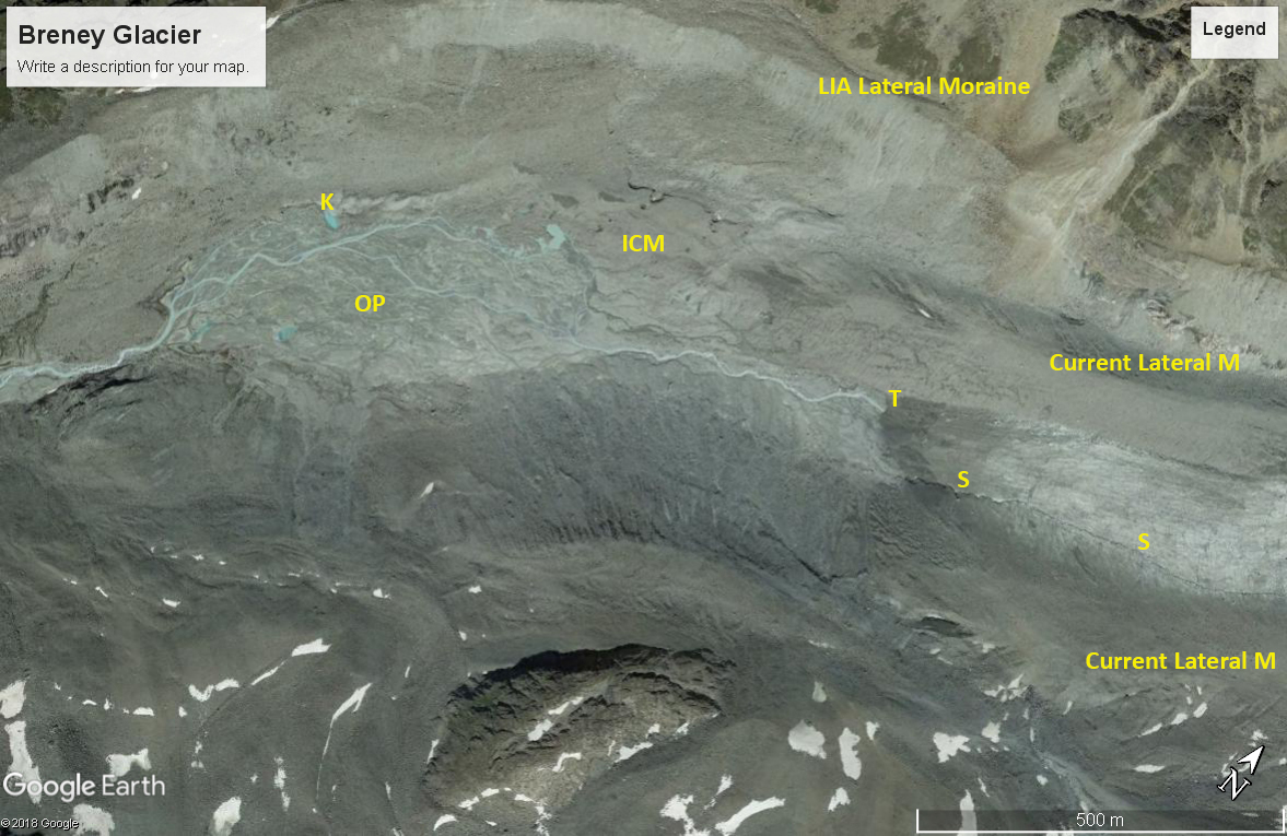
Google Earth image from 2016 of the terminus area of Breney Glacier. K=Kettle, OP=Outwash Plain, T=Terminus, S=Supraglacial stream, ICM=ice cored moraine.
 Dean of Academic Affairs at Nichols College and Professor of Environmental Science at Nichols College in Massachusetts since 1989. Glaciologist directing the North Cascade Glacier Climate Project since 1984. This project monitors the mass balance and behavior of more glaciers than any other in North America.