
October 2, 2018
High Glacier Snow Line Post-Monsoon 2018 on Bhutan-China Border
Posted by Mauri Pelto
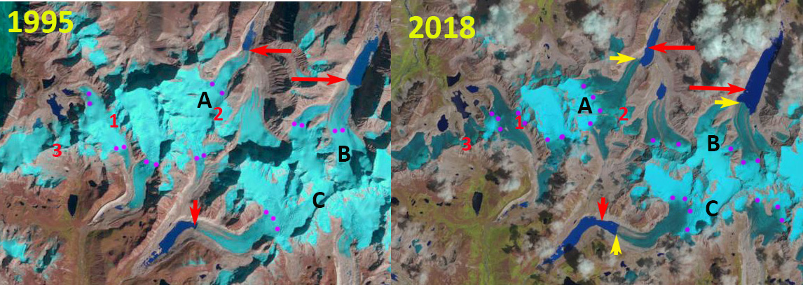
Angge Glacier (A) and Bailang Glacier (B) in China and Chubda Glacier (C) in Bhutan in Post Monsoon 1995 and 2018 Landsat images indicating the snowline purple dots is exceptionally high in 2018. Red arrow is the 1995 terminus location and yellow arrows the 2018 terminus location. Point 1-3 are glacier passes from China into Bhutan.
The end of the monsoon season leads to finally some clear satellite images of snowlines and glaciers in the Himalaya. A Landsat image from September 12, 2018 along the China-Bhutan indicates high snowlines (5500 m) that reach the top of some glaciers and the glacier divide between nations on other glaciers.
Bailang Glacier and Angge Glacier, China are adjacent to the Chubda Glacier, Bhutan. A These glaciers drain north and south from near Chura Kang on the Bhutan/China border. Despite being in different nations on different flanks of the Himalaya, the retreat and resultant lake expansion is the same. These are all summer accumulation type glaciers that end in proglacial lakes. All three lakes are impounded by broad moraines that show no sign of instability for a potential glacier lake outburst flood. The number of glacier lakes in the region has increased 20% (Che et al, 2014) The Chubda Glacier terminates in Chubda Tsho, a glacier moraine dammed lake, Komori (2011) notes that the moraine is still stable and the lake is shallow near the moraine, suggesting it is not a threat for a glacier lake outburst flood. Jain et al., (2015) noted that in the last decade the expansion rate of this lake has doubled. The glacier feeds the Chamkhar Chu Basin.
Here we examine 1995-2018 Landsat images from the post monsoon period to identify both retreat and the anomalously high snowlines in 2018. In 1995 the highest observed snowline is at 5300 m, purple dots, Point 1 -3 are glacier passes from China into Bhutan that are snowcovered. The glaciers terminate at the red arrows. In 2000 the highest observed snowline is 5250-5300 m. There is limited retreat since 1990. In 2017 the highest observed snowline is at 5300-5350 m. In 2018 the highest observed snowline is at 5500-5550 m. The glacier passes at Point 1 and 2 lack any snowcover. The glaciers at Point 3 have no retained snowcover despite top elevation above 5400 m. Bailang Glacier has retreated 900 m from 1995 to 2018 that has led to lake expansion. A retreat 1995-2018 retreat of 800 m of Angge Glacier has led to lake expansion. A retreat of Chubda Glacier of 800 m has led to lake expansion from 1995-2018 has led to lake expansion. 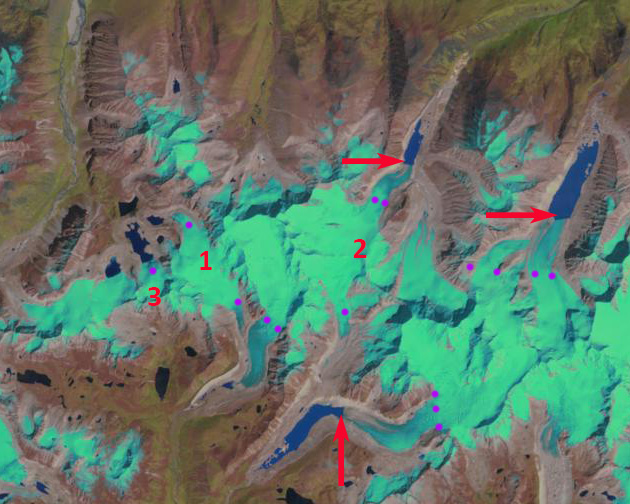
2000 Landsat image from the post monsoon indicating the snowline purple dots. Red arrow is the 1995 terminus location Point 1-3 are glacier passes from China into Bhutan.

2017 Landsat image from the post monsoon indicating the snowline purple dots. Red arrow is the 1995 terminus location Point 1-3 are glacier passes from China into Bhutan.

Sept. 12 2018 Landsat image indicating the snowline purple dots is exceptionally high in 2018. Red arrow is the 1995 terminus location and yellow arrows the 2018 terminus location. Point 1-3 are glacier passes from China into Bhutan.
 Dean of Academic Affairs at Nichols College and Professor of Environmental Science at Nichols College in Massachusetts since 1989. Glaciologist directing the North Cascade Glacier Climate Project since 1984. This project monitors the mass balance and behavior of more glaciers than any other in North America.