
September 7, 2018
Croker Bay Glacier, Nunavut Canada Poised for Further Retreat
Posted by Mauri Pelto
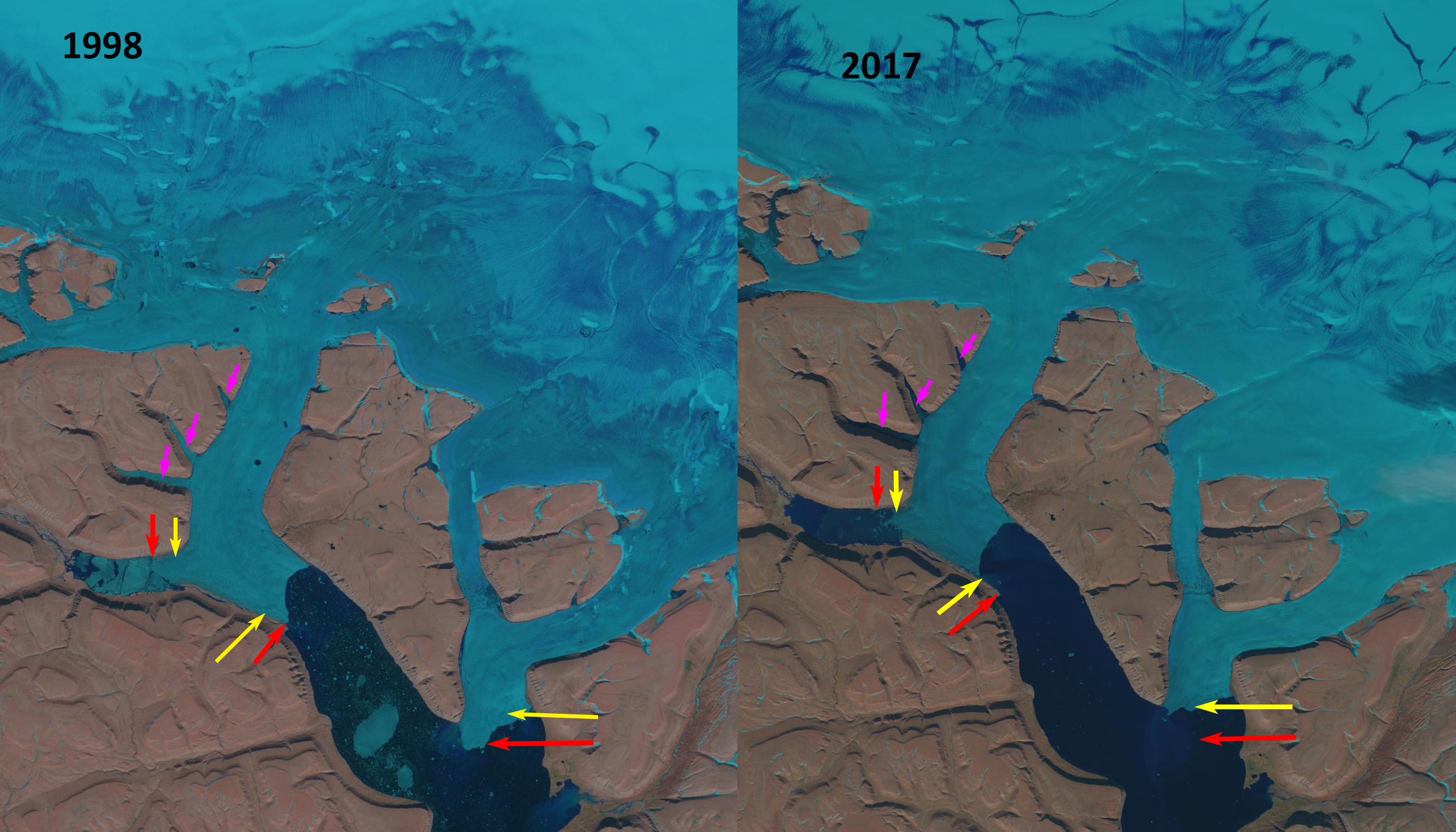
Croker Bay Glacier, Devon Ice Cap, Nunavut in Landsat images from 1998 and 2017. The red arrows indicate the 1998 terminus location, yellow arrows the 2017 terminus location. The pink arrows indicate three inlet on the north glacier.
Croker Bay Glacier drains the southwest quadrant of the Devon Ice Cap, Nunavut. A study by Van Wychen et al (2012) focused on velocity changes of the Devon ice Cap. They identify that Croker Bay Glacier has two main termini, the south and north terminus and that the region of higher velocity +100 m/year for these glaciers penetrates further into the ice cap than other outlets. This is on the opposite side of the ice cap from where three new islands have emerged due to retreat.
In 1998 the south terminus of Croker Glacier extends 1.2 km beyond the tip of the peninsula on its west margin. In 1998 the northern terminus has both an east and a west terminus. The west terminus extends up a side valley. The pink arrows indicate three side channels into which the glacier flows into the southern two. The transient snowline in 1998 is ~1100 m, with the crest of the ice cap at 1800 m. In 2001 there is limited change and a recent snowfall has covered most of the glacier. By 2017 the southern terminus has retreated to approximately parallel with the western margin peninsula, a distance of 1700 m. The northern terminus has retreated 1400 m on the eastern side and 1100 m on the western side. The result is a much thinner ice connection reaching the southern side of the Croker Bay fjord. The transient snowline is high at ~1100 m again. The 2018 image is from 2018. The snowline has already begun to decline due to a late summer snow event. There are a number of small icebergs in Croker Bay, particularly trapped in front of the western most terminus indicating continued calving retreat. The observations here are a local example resulting from the ongoing mass losses found on Canadian Arctic ice caps that have been losing mass for decades and that mass loss accelerated in 1996, Noel et al (2018). This has led to widespread area losses. White and Copland (2018) quantify the change in the areal extent of 1773 glaciers on Northern Ellesmere Island from 1999 to 2015. They found regional glacier area decreased by ∼6%, with not a single glacier increasing in areal extent.

Croker Bay Glacier, Devon Ice Cap, Nunavut in a Landsat image from 2001 and a Sentinel image from 2018. The red arrows indicate the 1998 terminus location, yellow arrows the 2017 terminus location. The pink arrows indicate three inlet on the north glacier.
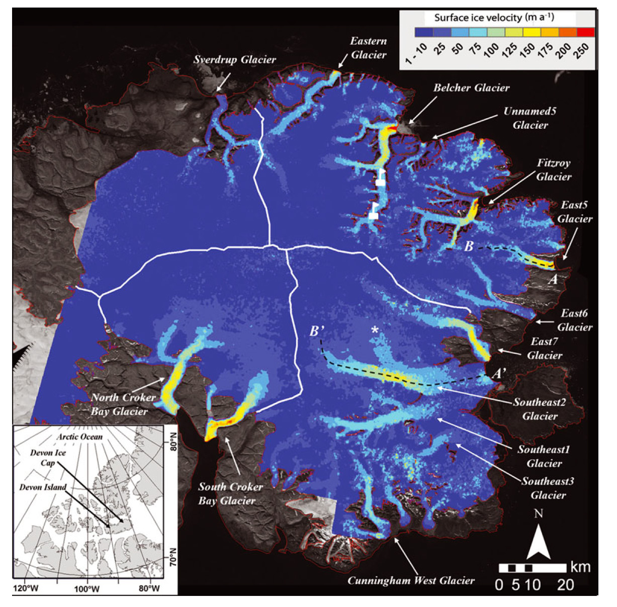
Velocity Map of Devon Ice Cap, which is Figure 1 from Van Wychen et al (2012)
 Dean of Academic Affairs at Nichols College and Professor of Environmental Science at Nichols College in Massachusetts since 1989. Glaciologist directing the North Cascade Glacier Climate Project since 1984. This project monitors the mass balance and behavior of more glaciers than any other in North America.