
July 5, 2018
Harbardsbreen, Norway Margin Retreat and Separation
Posted by Mauri Pelto
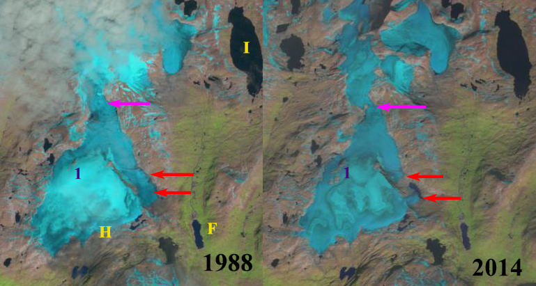
Harbardsbreen (H) the 13th largest ice cap in Norway in 1988 and 2014 Landsat images. Red arrows indicate the main terminus on the east side that has separated since 1988. Point 1 is the sole nunatak in 1988 now there are more. The Pink arrow is the location of the narrowing connection with the northern section of the icecap. The east side of the ice cap feeds the hydropower system of Fivelmyr (F) and Illvatnet Reservoir (I).
Harbardsbreen (H) is the 13th largest ice cap in Norway in the Norwegian Glacier Inventory with an area of 24.8 square kilometers in 2006. The ice cap is east of Jostedalsbreen. Here we examine Landsat imagery to indicate changes amidst and at the margin of this ice cap from 1988-2016. The east side of this ice cap drains into Fivelmyrane Reservoir (F) and its hydro power. The Fivelmyr Power Plant was built in 1962 and has an 8 GWh annual capacity. This water via pumped storage is also part of the Herva Power Plant that produces 129 GWh annually.
In 1988 the main outlet of the ice cap was a tongue of ice fed from both north and south outlet glaciers on the east side of the ice cap, not red arrows. There is a connection to the northern end at the pink arrow is nearly 1 km wide. At Point 1 there is a single nunatak amidst the ice cap. Up to 1998 there is limited change in the icecap. In 2014 the snowline is at 1700 m near the crest of the ice cap. The eastern terminus of Harbardsbreen has separated at the red arrows. A new lake has formed that is in contact with the southern terminus. The connection at the pink arrow to the northern segment is now just 200 m wide. There are now three new bedrock outcrops near Point 1 and the expanded former solitary nunatak. The expansion of the bedrock knobs indicate the impact of the rising snowline converting portions of the ice cap into an ablation zone that had been an accumulation zone. In 2016 the southeastern terminus of Harbardsbreen barely reaches the new lake that has formed. The glacier termini are now separated by 800 m from each other. The reduced size of the glacier means less area for melting, in this case the reduced natural ice storage can be replaced by the artificial pumped storage in Illvatnet. This same story is being told at nearby Spørteggbreen and Tunsbergdalsbreen.
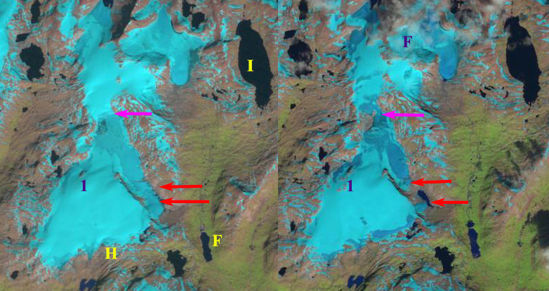
Harbardsbreen (H) the 13th largest ice cap in Norway in 1998 and 2016 Landsat images. Red arrows indicate the main terminus on the east side that has separated since 1998. Point 1 is the sole nunatak in 1998 now there are more. The Pink arrow is the location of the narrowing connection with the northern section of the icecap. The east side of the ice cap feeds the hydropower system of Fivelmyr (F) and Illvatnet Reservoir (I).

Harbardsbreen in the NVE Atlas showing 2006 glacier margins
 Dean of Academic Affairs at Nichols College and Professor of Environmental Science at Nichols College in Massachusetts since 1989. Glaciologist directing the North Cascade Glacier Climate Project since 1984. This project monitors the mass balance and behavior of more glaciers than any other in North America.