
June 23, 2018
Honeycomb Glacier Retreat, Washington New Lake Lost Nunatak
Posted by Mauri Pelto
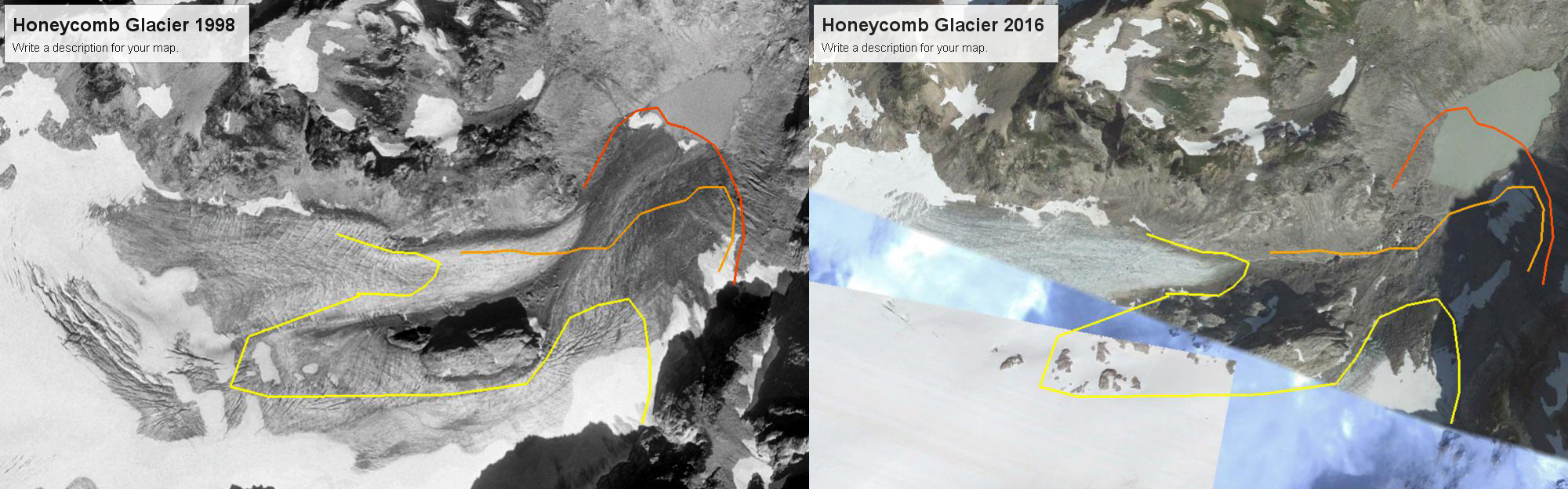
Honeycomb Glacier in Google Earth imagery from 1998 and 2016. The dark orange line is the 1998 margin, we mapped the margin in the field in 1995 and in 2002. The light orange line is the 2007 margin and the yellow line the 2016 margin. Note crevassing diminished as well.
Honeycomb Glacier is one of the longest and largest glaciers in the North Cascades. In 1979 it was 3.9 km long and had an area of 3.5 km2. By 2016 the area had declined to 2,6 km2 and it has retreated 2.6 kilometers since its Little Ice Age Maximum. The glacier was an imposing site to C.E. Rusk who recounted his early 20th century exploration (1924). Like all 47 glaciers observed by the North Cascade Glacier Climate Project it has retreated significantly since 1979. The glacier feeds the headwaters of the Suiattle River, which is also an important salmon stream, for chinook, coho, sockeye and pink salmon (WDFW,2018).
A 1960 photograph taken by Austin Post, USGS shows the glacier ending with no lake at its terminus. The terminus is gentle and has no crevasses, indicating it is relatively stagnant and poised to melt away. The glacier has retreated 1.3 km from its Little Ice Age moraines at this point. In 1967 another Austin Post image indicates a new small lake forming at the terminus.

In 1995 we mapped the margin of the glacier ending in this lake, where the glacier ended in 1967 and took a photograph back to the glacier. As seen below retreat to this point was 400 m.

A pair of images from Bill Arundell in 1973 and Lowell Skoog in 2006 indicate the scale of the retreat, these images do not show the actual terminus but do show the main nunatak-rock island and how much it has become exposed in the 33 years. This nunatak was hardly evident in 1960, and in a 1940 image of the glacier literally did not yet exist.
The terminus had retreated 400 m from the 1967 position to 1995. In 1987 a new lake began to form at the terminus of the glacier at 1680 m. The glacier is shown ending in this lake in 2002 from both the far end of the lake and the nunatak above the lake, the glacier had retreated 210 m since 1995. In 2006 the glacier retreated from the end of this lake. This is a shallow lake that may eventually be filled in by glacier sediments. The terminus is flat and stagnant ending at 1680 m in the lake. Thus, the rapid retreat will continue, the glacier is still not close to acheiving a post LIA equilibrium. Glacier retreat from 1940-1967 averaged 9 m/year. Retreat was minor between 1967 and 1979. The retreat rate from 1979-1998 was greater at 16 m/year, with a total retreat of 300 m. The retreat than increased from 1998-2016 with the west branch retreating 800 m and the east branch 500 m. The nunatak in the middle of the glacier, which was beneath the ice in 1940 was 90 m above the ice in 2002 when we mapped it. By 2009 it was no longer a nunatak as the glacier did not merge downstream of the this bedrock knob.
The retreat of this section of the glacier results in a reduced melt area of ~1 km2 in the last 40 years. This in turn reduces summer glacier runoff as there is no longer snow/ice melting each day under the warm summer conditions. Flow in the Suiattle River in late summer and early fall has declined as a result. In 2002 during mapping of the glacier images from above and below the nunatak indicate the stagnant nature of the ice below the nunatak.


 Dean of Academic Affairs at Nichols College and Professor of Environmental Science at Nichols College in Massachusetts since 1989. Glaciologist directing the North Cascade Glacier Climate Project since 1984. This project monitors the mass balance and behavior of more glaciers than any other in North America.
Dear Professor Pelto,
I have a question that has troubled me which perhaps you can answer.
If the snow line rises by say 500 m, will the site of the terminus of a glacier also rise by 500 m, and do glaciologists take this into consideration which estimating the retreat of glaciers?
It seems to me that if the snow line rises then the accumulation area will decrease and so the terminus will retreat even further.
Cheers, Alastair.
If the snow line rises by a specific number of meters, that does not equate to the terminus rising by a similar number of meters. The actual accumulation area will determine the size of the ablation area and that along with the variation in glacier width from accumulation to ablation area determines length of terminus. If we have a steep narrow glacier tongue the retreat will be different than for a wide low slope glacier tongue.
Exactly Sir and rate is also differ between snow line height and terminus retreat.