
May 17, 2018
Winter Season Ablation in 2018 Mount Everest Region, Himalaya
Posted by Mauri Pelto
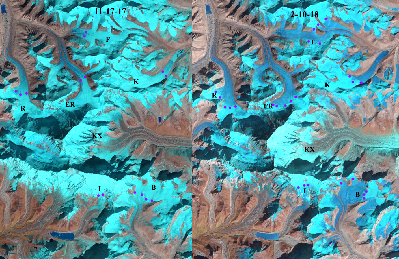
Landsat images from Nov. 17 2017 and Feb. 10 2018 indicate a rise in the snowline, purple dots, on glaciers east of Mount Everest, indicating ablation even in winter from the terminus to the snowline. Rongbuk Glacier=R, East Rongbuk Glacier=ER Far East Rongbuk Glacier=F, Kada Glacier=K, Barun Glacier=B, Imja Glacier=I and Kangshung Glacier=KX.
The Mount Everest region glaciers are summer accumulation type glaciers with 70% of the annual precipitation occurring during the summer monsoon. This coincides with the highest melt rates low on the glacier. October has been considered the end of the melt season in the region. There is little precipitation early in the winter season (November-January). The limited snowpack with warmer winter temperatures have led to high snowlines during the first few months of the winter season in recent years. There is an expanded ablation season that extends beyond October into January or February. The melt rates do to solar radiation or sublimation are not rapid, but are significant on many glaciers. This has occurred with increasing air temperatures since the 1980’s. Mean annual air temperatures have increased by 0.62 °C per decade over the last 49 years; the greatest warming trend is observed in winter, the smallest in summer (Yang et al., 2011). The winter season of 2017-18 has been warm in the region as indicated by global temperature anomalies from, NCDC/NOAA (at right). 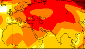 Here we examine Landsat images from Oct. 21 2017, Nov. 17 2018 and Feb. 10 2018 on the east side of Mount Everest to observe changes in the snowline during the winter period. We observed the same phenomenon of high snowlines and winter ablation at Nup La on the west side of Mount Everest in January of 2016, On Chutenjima Glacier, China in 2016 and Gangotri Glacier, India in 2016 (see below).
At the end of the typical melt season on 10-21-2017, the snowline is at 5850 m on Rongbuk Glacier, 6250 m on East Rongbuk Glacier, 6300 m on Far East Rongbuk Glacier, 5900 m on Kada Glacier, 6050 m on Barun Glacier and ~6100 m on Imja Glacier.
A month later on 11-17-2017 the snowline has decreased to 5700 m on Rongbuk Glacier, 6200 m on East Rongbuk Glacier, 6200 m on Far East Rongbuk Glacier, 5820 m on Kada Glacier, 5950 m on Barun Glacier and still at ~6100 m on Imja Glacier.
Three months later on 2-10-2018 the snowline has risen indicating ablation from the terminus area up to the snowline. The snowline is at 5900 m on Rongbuk Glacier, 6400 m on East Rongbuk Glacier, 6400 m on Far East Rongbuk Glacier, 5950 m on Kada Glacier, 6200 m on Barun Glacier and 6600 m on Imja Glacier. Notice on Far East Rongbuk Glacier the snowline reaches the glacier divide in February. The mean rise in snowline from November 2017-February 2018 on the east side of Mount Everest is 200 m.
The ablation rates necessary to raise the snowline are not large on a daily basis, but cumulatively are significant as noted on Lirung Glacier by Chand et al (2015)
Kundu et al (2015) noted that from Sept. 2012 to January 2013 the snowline elevation on Gangotri Glacier varied little, with the highest elevation being 5174 m and the lowest 5080 m. Bolch et al (2011) observed strong thinning in the accumulation zone on Khumbu Glacier, though much less than the ablation zone. This can only happen with reduced retained snowpack particularly in winter.
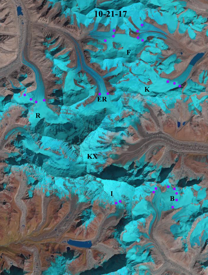
Landsat image from Oct. 21 2017 indicate a rise in the snowline, purple dots, on glaciers east of Mount Everest, indicating ablation even in winter from the terminus to the snowline. Rongbuk Glacier=R, East Rongbuk Glacier=ER Far East Rongbuk Glacier=F, Kada Glacier=K, Barun Glacier=B, Imja Glacier=I and Kangshung Glacier=KX.
W
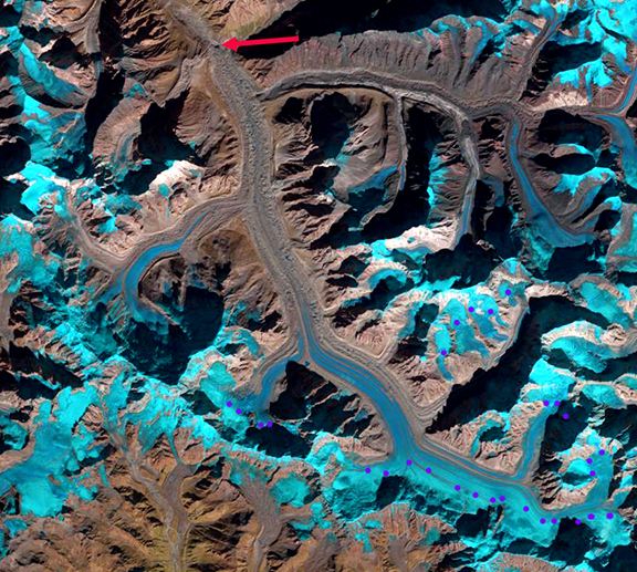
Purple dots indicate the transient snowline on Gangotri Glacier in the fall and early winter of 2016. Red arrow indicates the terminus of the glacier. Landsat 12-9-16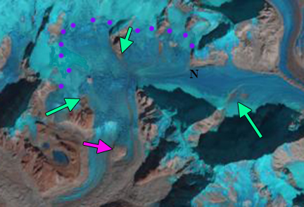
Landsat image from January 4, 2016 indicating the actual Nup La (N), west side of Mount Everest. Purples dots is the snowline. Green arrows are expanding bedrock exposures and pink arrow a specific rock know amidst the glacier.
 Dean of Academic Affairs at Nichols College and Professor of Environmental Science at Nichols College in Massachusetts since 1989. Glaciologist directing the North Cascade Glacier Climate Project since 1984. This project monitors the mass balance and behavior of more glaciers than any other in North America.