
May 15, 2018
Popof Glacier Retreat, Alaska Features Tributary Separation
Posted by Mauri Pelto
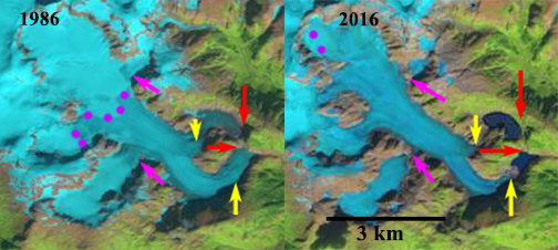
Popof Glacier comparison in 1986 and 2016 Landsat images. Red arrow is the 1986 terminus location, yellow arrows the 2016 terminus location, pink arrows indicate two key tributaries and purple dots indicate the snowline.
Popof Glacier is at the southern end of the Stiking Icefield in southeast Alaska. In 1948 the glacier had two terminus sections that separated around Mount Basargin and then rejoined. By 1979 the glacier termini were separated (Molnia, 2008). Here we examine Landsat imagery from 1986-2016 to identify changes in the glacier.
In 1986 both glacier termini were located at the far end of a basin, with no proglacial lakes in existence. The termini were separated from each other by 400 m after nearly wrapping all the way around Mount Barsargin. The first tributary to join main glacier from both the west and east were connected to the main glacier, pink arrows. The snowline in 1986 was at 800 m. By 1999 the northern terminus tongue had disintegrated extending only a few hundred meters from the main glacier and forming a new lake. A fringing proglacial lake had developed at the main or southern terminus. The snowline was at 750-800 m. The first tributaries entering from east and west still reach the main glacier. In 2015 the snowline is nearly at the summit of the glacier at 925 m. The main terminus has retreated from the proglacial lake that formed in the 1990’s. The first tributaries entering from east and west no longer reach the main glacier. In 2016 the snowline is at 950 m, even higher than in 2015, with less than 5% of the glacier retaining snowcover. The main terminus has retreated 700 m from 1986 to 2016 and the northern terminus 1.7 km from 1986-2016. The retreat is less spectacular than the nearby Shakes Glacier and Great Glacier, though both of those glaciers have retained a substantial accumulation zone. The Popof Glacier cannot survive with snowlines as high as those seen in 2015 and 2016.
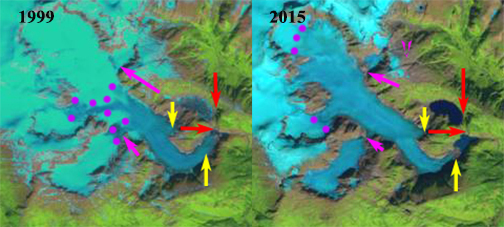
Popof Glacier comparison in 1999 and 2015 Landsat images. Red arrow is the 1986 terminus location, yellow arrows the 2016 terminus location, pink arrows indicate two key tributaries and purple dots indicate the snowline.
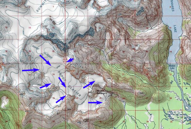
Popof Glacier in 1979 USGS map of the region, indicating flow directions.
 Dean of Academic Affairs at Nichols College and Professor of Environmental Science at Nichols College in Massachusetts since 1989. Glaciologist directing the North Cascade Glacier Climate Project since 1984. This project monitors the mass balance and behavior of more glaciers than any other in North America.