
March 19, 2018
Sermeq Kuadtleq, Greenland Retreat Island Development Nunatak Expansion.
Posted by Mauri Pelto
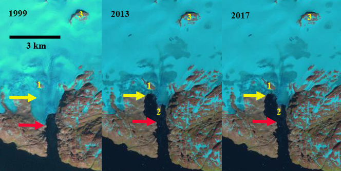
Sermeq Kuadtleq in Landsat images from 1999, 2013 and 2017. The red arrow is the 1999 terminus location, yellow arrow is the 2017 terminus location. Nunatak 1 and 3 are noted and the developing Island 2.
Sermeq Kuadtleq (not only glacier in Greenland with this name) flows south to Prince Christian Sound from an icecap peripheral to, but connected to the Greenland Ice Sheet. As such the glacier is not impacted directly by ice sheet changes. Here we examine changes from 1999-2017. Greenland tidewater outlet glaciers in this region have experienced substantial retreat since 1990 Weidick et al (2012) and Howat and Eddy (2011). Tasermiut Fjord and Alangordlia Fjord are southern Greenland fjords that have lost their tidewater glacier connections. Kangersuneq Qingordleq is a similar example near Prince Christina Sound that is a retreating tidewater glacier that is not connected to the main GIS.
In 1999 the glacier extends to within km of the main sound, red arrow on west margin. There are two nunataks noted Nunatak 1 is in the ablation zone and Nunatak 3 is in the accumulation zone. In 1999 and again in 2002 the snowline is a short distance above Nunatak 1 at 600-650 m. By 2013 the glacier has retreated expanding the fjord, and a new island at the margin, Island 2 has emerged from beneath ice and is helping stabilize the east half of the terminus. Nunatak 1 and 3 are also more expansive. In 2013 and 2016 the snowline is at 700 m. In 2017 the western margin of the glacier has retreated 1600 m since 1999 and eastern margin has retreated 600 m. The connection to Island 2 is also been reduced since 2013. Once the connection is lost the east margin will retreat faster. The glacier is still a tidewater glacier, but is within a km of what will be the head of the fjord, based on the steep surface slopes shortly above the terminus. The glacier will lose its connection to tidewater like glaciers in Tasermiut Fjord. Currently the retreat is relatively rapid like other tidewater glaciers near the southern edge of the GIS. The glacier just to the east has lost connection to tidewater, pink arrow, note on map as emptying into Sermilerajik. The behavior of this glacier matches other nearby glaciers including Kangersuneq Qingordleq and the glacier entering the Kangerdluk Fjord just to the west (This is again not the only fjord with this name).

Greenland topographic map, from Nuna GIS, of the eastern end of Prince Christina Sound. Note blue arrow indicates Sermeq Kuatdleq and pink arrow Sermilerajik, which no longer reaches tidewater.
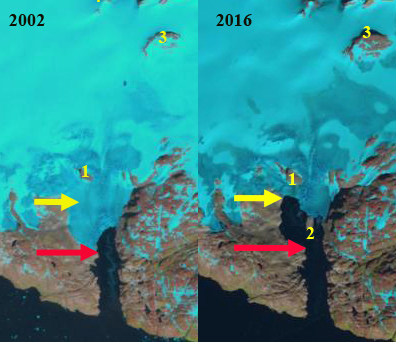
Sermeq Kuatdleq in Landsat images from 2002 and 2016. The red arrow is the 1999 terminus location, yellow arrow is the 2017 terminus location. Nunatak 1 and 3 are noted and the developing Island 2.
 Dean of Academic Affairs at Nichols College and Professor of Environmental Science at Nichols College in Massachusetts since 1989. Glaciologist directing the North Cascade Glacier Climate Project since 1984. This project monitors the mass balance and behavior of more glaciers than any other in North America.
I have a detailed very sharp picture of this exact area I took with a 61mpx camera with at 105mm focal lenght on a super clean bright day while flying from Iceland to Canada (september 6th at 9:59 local Greenland time) the glacier is not tuching island 2…