
January 30, 2018
Franz Josef Islands Separate due to Glacier Retreat
Posted by Mauri Pelto
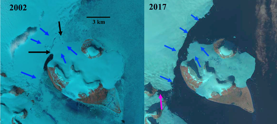
Hall Island (left) and Littrow Island (right) in 2002 and 2017 Landsat images. The islands are connected by glacier in 2002 between the black arrows. The blue arrows indicate glacier flow. In 2017 the glacier connection has failed and Nordenskjold Strait has formed.
Hall and Littrow Island are two islands in the southern part of Franz Josef Land, Russia that have until 2016 been connected by glacier. Sharov et al (2014) generated a map with the MAIRES Project illustrating the glacier connection was failing, see below. Sharov and Nikolskiy (2017) further report on the failure of this glacier connection. Here we utilize Landsat imagery from 2000-2017 to illustrate the change.
In 2000 the island are surrounded by considerable sea ice and there is a 3 km wide glacier connection, black arrows. In 2002 the island are again surrounded by considerable sea ice that is distinguishable from the glacier ice. The glacier connection between the island remains 3 km wide, black arrows, with blue arrows showing the direction of ice movement. By 2013 the connection has narrowed to 0.7 km and there is no sea ice. In 2016 the glacier connection is gone between hall and Littrow Island and Nordenskjold Strait has formed. There is sea ice on the northern shore of Littrow Island reaching to Hall Island. To the southwest the pink arrow indicates where the Sonklar Glacier connects with an unnamed glacier in 2016. In 2017 there again is no sea ice and the open water between Littrow Island and Hall Island is more apparent. The inlet averages 800 m in width. The connection between Sonklar Glacier and the neighboring glacier, at the pink arrow, has failed. The lack of sea ice in the region is exposing the marine margins of the ice caps in Franz Josef Land to enhanced melting. This has and will lead to more coastal changes and island separations.
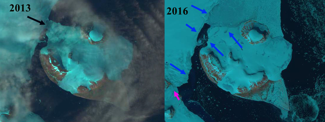
Hall Island and Littrow Island in 2013 and 2016 Landsat images. The black arrow indicates a narrow connection in 2013. In 2016 the glacier connection has failed and Nordenskjold Strait has formed.

Map from MAIRES (Monitoring Arctic Land and Sea Ice from Russian and European satellites) showing the changing connection between islands.

2000 Landsat image indicating connection between islands at black arrows.
 Dean of Academic Affairs at Nichols College and Professor of Environmental Science at Nichols College in Massachusetts since 1989. Glaciologist directing the North Cascade Glacier Climate Project since 1984. This project monitors the mass balance and behavior of more glaciers than any other in North America.