
December 21, 2017
Queulat Norte Glacier, Chile Retreat Creates Two Lakes
Posted by Mauri Pelto
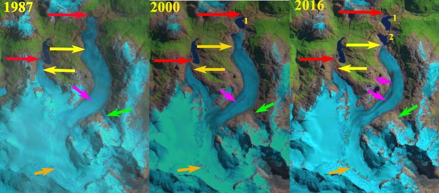
Queulat Norte Glacier in 1987, 2000 and 2016 Landsat images indicating retreat from 1987 (red arrow) to 2016 (yellow arrow). Green arrow indicates former tributary, orange arrow area of new bedrock exposure and pink arrow expanding medial moraine. Two new lakes have formed due to the 1950 m retreat.
Nevado Queulat, Chile is the centerpiece of the Queulat National Park in the Aysen Region. The largest glacier draining the substantial ice cap on this mountain flows north draining into Lago Rosselot and then the Rio Palena. Here we examine 1987 to 2016 Landsat imagery to identify changes in this glacier. Paul and Molg (2014) observed a rapid retreat in general of 25% total area lost from glaciers in the Palena district of northern Patagonia from 1985-2011.
In 1987 the glacier terminates against the valley where the valley turns to the east, red arrow. There is no lake at the terminus. The tributary at the green arrow connects to the main glacier. There is no evident medial moraine at pink arrow. There is no exposed bedrock in the accumulation zone at orange arrow. In 2000 glacier retreat has exposed a new lake that is 900 m across. The tributary at the green arrow is no longer connected. A medial moraine s evident at the pink arrow and bedrock is exposed at orange arrow. By 2016 the glacier has retreated south of a second lake that is 700 m across. Total retreat from 1987-2016 has been 1950 m, 65 m per year. This is the loss of 15% of the entire glacier length. The medial moraine has expanded up and downglacier indicating greater melting and an upward shift of the snowline. The area at the orange arrow is a significant band of bedrock, indicating that this is no longer an accumulation zone. This bedrock is at 1700 m, the current terminus is at 600 m and the top of the glacier is at 2000 m, leaving only a 300 m elevation band in the accumulation zone. Examination of the region just above the terminus indicates significant ablation hollows/depressions indicative of stagnant ice, green arrows. There is also an area of debris from a subglacial stream emerging at the surface yellow arrow. The retreat is as significant as that of Erasmo Glacier as a percentage of glacier size.
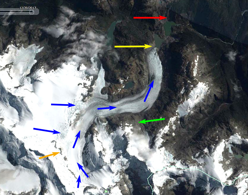
2016 Google Earth image of Queulat Norte Glacier indicating retreat from 1987 (red arrow) to 2016 (yellow arrow). Green arrow indicates former tributary, orange arrow area of new bedrock exposure and blue arrows indicating flow.

Stagnant nature of the lower glacier in 2016 with ablation hollows/depressions at green arrows and yellow arrow indicating sub-glacial stream that emerges at surface and deposits debris.
 Dean of Academic Affairs at Nichols College and Professor of Environmental Science at Nichols College in Massachusetts since 1989. Glaciologist directing the North Cascade Glacier Climate Project since 1984. This project monitors the mass balance and behavior of more glaciers than any other in North America.