
September 28, 2017
Bishop Glacier Retreat, British Columbia Generates Substantial Alpine Lake
Posted by Mauri Pelto
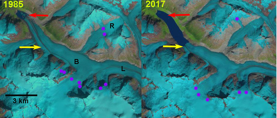
Bishop Glacier retreat in Landsat images from 1985 and 2017, 3000 m retreat. Red arrow is the 1985 terminus, yellow arrow is the 2017 terminus, purple dots is the snowline. B=Bishop, R=Ring, L=Lillooet.
Bishop Glacier is a 10.5 km long western outlet glacier of the Lillooet Icefield in British Columbia. The glacier shares a divide with the eastern outlet Lillooet Glacier at 1750 m. The glacier from 1985-2017 has ended in a rapidly expanding glacial lake. Here we examine the retreat using Landsat imagery from 1985-2017. Bridge Glacier drains east from the same icefield and after a period of sustained retreat, 30 m per year from 1981-2005 (Allen and Smith, 2007), calving enhanced the retreat from 2004-2016 averaging 250 m/year (Pelto, 2017). Chernos (2016) observed that as Bridge Glacier neared the upglacier end of the developing lake basin retreat would slow.
In 1985 Bishop Glacier terminated in a 1 km long proglacial lake at 1300 m. Ring Glacier was the main tributary, joining from the north. The snowline averaged 2000 m. By 1993 the lake had expanded to a length of 2.25 km, the snowline was at 2150 m and Ring Glacier was barely connected to the main glacier. From 1993-2002 retreat was slower with the lake expanding to 2.5 km in length, the snowline was at 1950 m and Ring Glacier had detached from Bishop Glacier. In 2016 the snowline was at 2300 m and the lake was relatively free of icebergs. In 2017 the proglacial lake is 4 km with a glacier retreat of 3000 m in 32 years. Ring Glacier has retreated 800 m from Bishop Glacier. The lake is relatively free of icebergs in 2017 as well, suggesting a reduced calving rate in recent years. There is an increase in slope 1 km above the terminus, pink arrow in Google Earth image suggesting this is the maximum distance the lake will extend upvalley. Retreat should slow due to reduced calving, but will continue as indicated by the Ring Glacier and others retreating that are not calving glaciers. The snowline in 2017 despite a snowy winter is quite high at 2300 m. The retreat is similar to other valley glaciers in the region Jacobsen Glacier Klippi Glacier.

Bishop Glacier retreat in Landsat images from 1993 and 2016. Red arrow is the 1985 terminus, yellow arrow is the 2017 terminus, purple dots is the snowline.
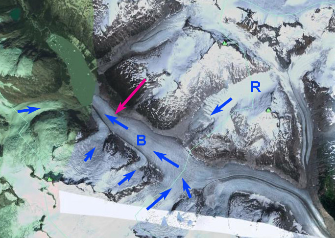
Google Earth image of Bishop and Ring Glacier, pink arrow shows the change in slope.

Bishop Glacier retreat in Landsat images from 2002. Red arrow is the 1985 terminus, yellow arrow is the 2017 terminus, purple dots is the snowline.
 Dean of Academic Affairs at Nichols College and Professor of Environmental Science at Nichols College in Massachusetts since 1989. Glaciologist directing the North Cascade Glacier Climate Project since 1984. This project monitors the mass balance and behavior of more glaciers than any other in North America.
Mauri,
Have a look at these images…
https://roammedia.com/kayaking-first-descent-bishop-river/
More…
https://kokatat.com/blog/bishop-river