
June 22, 2017
Bonnet Glacier, Alberta Retreat & New Lake Formation
Posted by Mauri Pelto
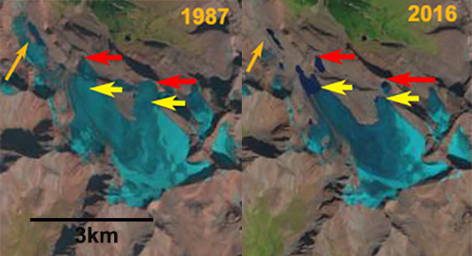
Bonnet Glacier, Alberta compared in Landsat images from 1987 and 2016. The red arrows mark the 1987 terminus, yellow arrows are the 2016 terminus location and the orange arrow notes a separate glacier that has disappeared.
Bonnet Glacier is at the headwaters of Douglas Creek that feeds into the Red Deer River. The glacier drains north from Bonnet Peak in the Sawback Range 30 km east of the crest of the Rocky Mountains and 40 km north of Banff. Here we examine changes in this glacier from 1987 to 2016, a period when retreat has led to the formation of new alpine lakes. An inventory of glaciers in the Canadian Rockies indicate area loss of 15% from 1985 to 2005 (Bolch et al, 2010), with Alberta glaciers losing area at a higher rate. Tennant et al (2012) noted that from 1919-2006 the glaciers in the central and southern Canadian Rocky Mountains lost 40% of their area. Of the 523 glaciers they observed 17 disappeared and 124 separated. The more famous Columbia Icefield, 125km northwest, has lost 23 % of its area from 1919-2009 with ice loss at a minimum during the 1970′s (Tennant and Menounos, 2013).
In 1987 the glacier had two primary termini, red arrows with no evident proglacial lakes at either terminus, red arrows. In 1987 the glacier spilled over a bedrock bench shortly above the terminus in both cases onto a lower bench The glacier has 25% retained snowpack. The orange arrow indicates a small avalanche fed glacier on the east side of the ridge extending north from the glacier. In 1988 the lack of proglacial lakes is noted at the pink arrows. The retained snowpack is again 25% of the glacier area, well short of the 50-60% needed for a glacier to be in equilibrium. In 1990 the snowcovered area is 30% there is a small lake developing at the northern most terminus. In 2015 four new alpine lakes have formed two are separated from the glacier due to retreat, with both active termini also terminating in lakes. The retained snowpack covers 10% of the glacier in 2015. In 2016 snowcover is retained on 20% of the glacier. The glacier has lost 20% of its total area since 1987 with the main terminus retreating 900 m and the secondary terminus 425 m. The 900 m retreat is ~20% of the total glacier length. The lack of retained snowcover even in these August Landsat images indicate a glacier that cannot survive current climate. The retreat is less impressive than on the larger Freshfield Glacier and more in line with retreat and separation seen on Conway Glacier and Fraser Glacier.

Bonnet Glacier, Alberta compared in Landsat images from 1988, 1990 and 2015. The pink arrows mark the locations where lakes developed after 1988 and the orange arrow notes a separate glacier that has disappeared.
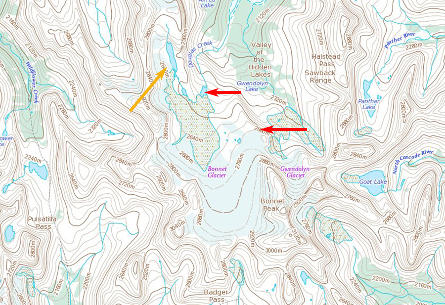
Topographic map of the Bonnet Glacier region, Alberta.
 Dean of Academic Affairs at Nichols College and Professor of Environmental Science at Nichols College in Massachusetts since 1989. Glaciologist directing the North Cascade Glacier Climate Project since 1984. This project monitors the mass balance and behavior of more glaciers than any other in North America.