December 5, 2016
Nevado Soral, Bolivia Glacier Retreat Separation Imminent 1988-2016
Posted by Mauri Pelto
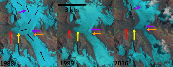
Landsat comparison from 1988 to 2016 of Nevado Soral Glaciers, Bolivia. Red arrow is the 1988 terminus, yellow arrow the 2016 terminus, orange arrow is the glacier junction and the purple arrow areas of rock expansion indicating upglacier thinning.
Nevado Soral is in the Cordillera Apolobamba Range of the Bolivian Andes. A significant valley glacier flows south from the mountain joining a northward flowing glacier shortly above the terminus. The combined runoff of these glaciers drains in to Laguna Suches, which is transected by the Bolivia-Peru Border. Cook et al (2016) quantify the importance of the Bolivian Andes Glaciers for water supply for Andean cities and mountain communities. They used Landsat satellite imagery to identify an overall areal shrinkage of 228 km2 (43%) across the Bolivian Cordillera Oriental between 1986 and 2014, including 43% in the Cordillera Apolobamba, where Nevado Soral is located. Retreat has led to a growing number of lakes, although the number of ice-contact lakes has decreased. Vuille et al (2008) noted that air temperature in the Andes has increased by approximately 0.1 °C/decade, with only two of the last 20 years being below the 1961–90 average. Soruco et al 2009) observed glacier change in the Cordillera Real of Bolivia and determined that between 1963 and 2006 the mass of these glaciers has clearly been decreasing since 1975 without any significant acceleration of this trend over recent years. The net result was that glaciers lost 43% of their volume between 1975 and 2006. On nearby Chaupi Orko Glacier retreat has been less extensive, but several new lakes have formed in the last two decades.
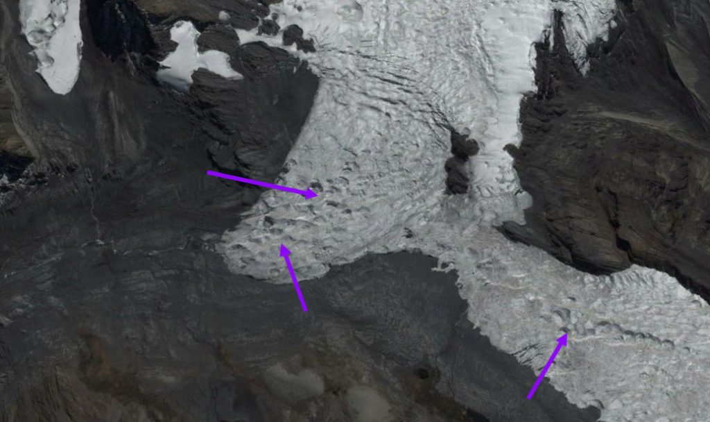
In 1988 the junction where the north and south flowing glacier meet and turn west is 800 m wide, orange arrow. The main glacier terminus is at m, red arrow. The purple arrows indicate areas where no bedrock is exposed. In 1999 there is 250-300 m of retreat and bedrock is still not exposed at the purple arrows. By 2016 the main terminus has retreated 800 m since 1988. The junction of the glacier is only 300 m wide. The purple arrows indicate locations where bedrock has been exposed by glacier thinning. A Google Earth closeup below indicates significant ablation hollows, and few surface streams, suggesting that sublimation is an important means of ablation on the glacier. The narrow junction of the two glaciers will soon melt, leaving two separate glaciers.
Terminus zone of Nevado Soral Glacier. Purple arrows indicate ablation hollows are as common as stream channels. This typifies an area where sublimation is a significant source of ablation.
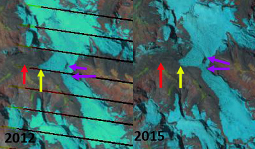
Landsat comparison from 2012 and 2015 of Nevado Soral Glaciers, Bolivia. Red arrow is the 1988 terminus, yellow arrow the 2016 terminus and the purple arrow areas of rock expansion indicating upglacier thinning.
Nevado Soral Glacier drains into Laguna Suches.


 Dean of Academic Affairs at Nichols College and Professor of Environmental Science at Nichols College in Massachusetts since 1989. Glaciologist directing the North Cascade Glacier Climate Project since 1984. This project monitors the mass balance and behavior of more glaciers than any other in North America.