June 14, 2016
Harris Glacier Retreat, Kenai Fjords, Alaska
Posted by Mauri Pelto
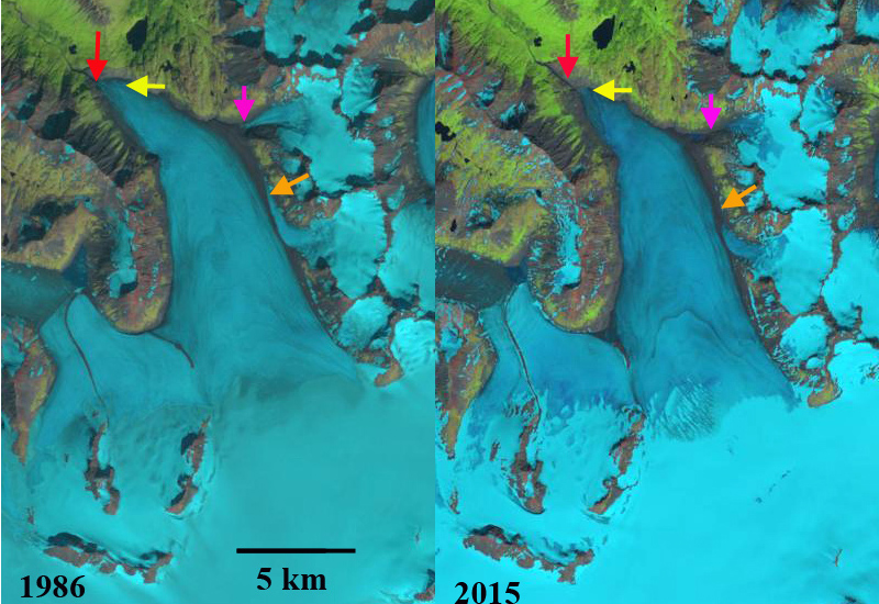
Landsat images of Harris Glacier from 1986 and 2015. The red arrow indicates 1986 terminus location, yellow arrow the 2015 terminus position. The orange arrow indicates a key eastern tributary and the pink arrow a smaller eastern tributary.
Harris Glacier flows from the northwest corner of the Harding Icefield, Alaska and it drains into Skilak Lake. The glaciers that drain east toward are in the Kenai Fjords National Park, which has a monitoring program. Giffen et al (2014) observed the retreat of glaciers in the region. From 1950-2005 all 27 glaciers in the Kenai Icefield region examined are retreating. Giffen et al (2014) observed that Harris Glacier (A Glacier) retreated 469 m from from 1986-2005. Here we examine Landsat imagery from 1986-2015 to illustrate the retreat of this glacier and other upglacier changes. The glacier supplies meltwater to Skilak Lake which is a critical salmon habitat for the Kenai. Chinook Salmon spawn on a section of the Kenai River between Kenai Lake and Skilak Lake. With Skilak Lake being the resulting home for ninety percent of the salmon fry for the Kenai River, and with the most of any nursery in the Cook Inlet area. Escapements of chinook in the Kenai River exceed 50,000 annually in two runs (Heard et al 2007).
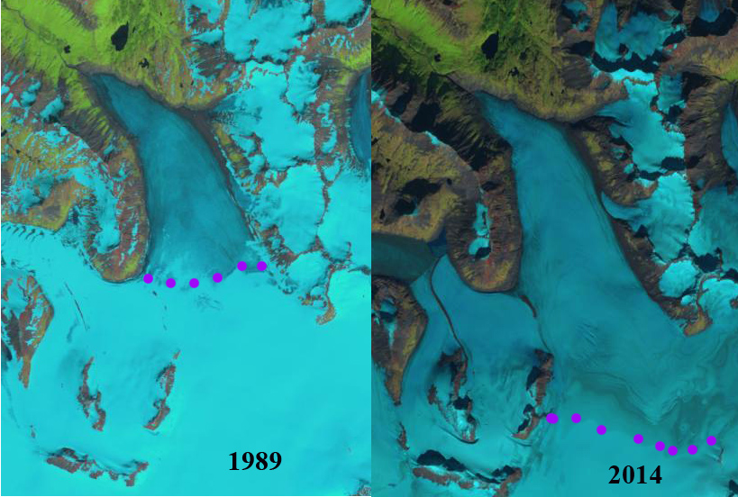
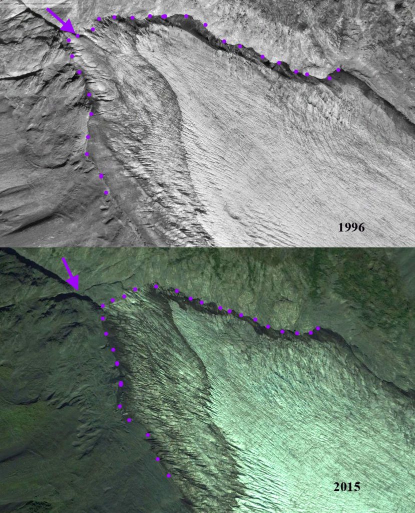
In 1986 the glacier extended to an elevation of 590 m, on the east side of the glacier there were two smaller tributaries reaching the glacier at the orange and pink arrow. By 2015 the terminus had retreated 600 m from 1986. The eastern tributary at the pink arrow had detached from the main glacier. The tributary at the orange arrow still reaches the main glacier, but the blue ice extent after joining the glacier has diminished significantly. Below is a closeup of the terminus from 1996 and 2015 illustrating a 225 m retreat and associated thinning. It is also interesting to note the prominent ash layer has shifted little. This suggests the terminus area is relatively stagnant. There is no active crevassing in the lower 1 km suggesting retreat will be ongoing. In 1989 the snowline is at 975 m whereas in 2014 the snowline is at 1125 m. This higher snowline is too high to maintain the glacier. The snowline in 2015 was again above 1100 m, though it is lower in the mid-August image at 1050 m. The retreat of this glacier is less than neighboring glaciers such as Grewingk, Pederson and Bear Glacier that have calving termini.
Landsat images from 1989 and 2014, with the snowline indicated by purple dots.
Terminus of Harris Glacier in Google Earth images from 1996 and 2015. Margin with purple dot, purple arrow indicates 1996 terminus lcoation, with a 225 m retreat by 2015. Note the prominent ash layer


 Dean of Academic Affairs at Nichols College and Professor of Environmental Science at Nichols College in Massachusetts since 1989. Glaciologist directing the North Cascade Glacier Climate Project since 1984. This project monitors the mass balance and behavior of more glaciers than any other in North America.