
December 3, 2015
Twin Glacier, Alaska Retreats from Twin Lake
Posted by Mauri Pelto
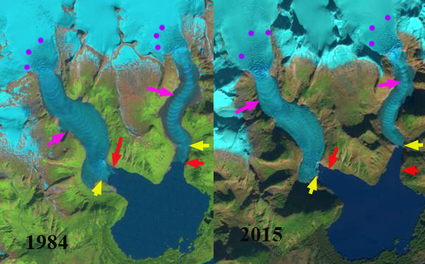
Landsat image comparospm pf 1984 and 2015. The yellow arrow indicates 2015 terminus, red arrow the 1984 terminus, pink arrows the ogives and purple dots the snowline on the day of the image.
Twin Glacier is an outlet glacier of the Juneau Icefield flowing south into the Taku River valley, terminating in Twin Lake. There are two terminus arms the East and West Twin Glacier are receding up separate fjords, though they are fed from a joint accumulation zone. The Juneau Icefield has been a focus of study by the Juneau Icefield Research Program since 1946. This program led to my first visit to the glacier as a member of the program in 1982 and again in 1984. Both glacier arms have pronounced ogives formed in the icefall that descends from the accumulation zone into the valley reach ablation zone. Ogives form annually from the seasonal variation of velocity through the icefall. An examination of the change in Juneau Icefield glaciers using Landsat images from 1984 and 2013 identify a significant retreat that has continued into 2015.
The West Twin has retreated 600 m from 1983 to 2013, at an elbow in the fjord. Elbows like this are often good pinning points that are a more stable setting. This elbow also represents the point at which the glacier terminus is pulling out of the lake that it is calved into for over a century. The bedrock at the terminus is evident in both 2006 imagery and a 2015 image from the Wings Airways five glacier seaplane discovery tour, black arrows. The glacier will no longer be calving, which should also slow the retreat rate.
Google Earth Image 2006
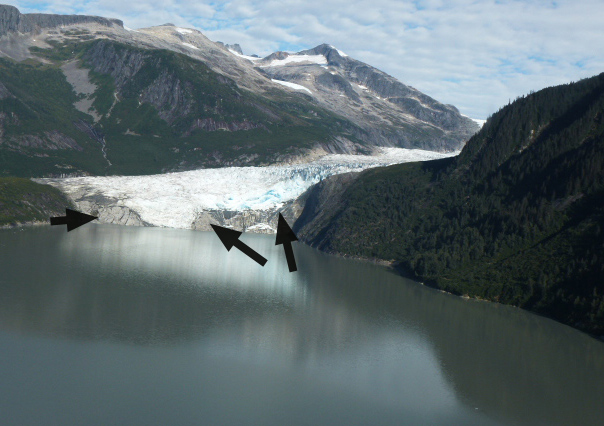
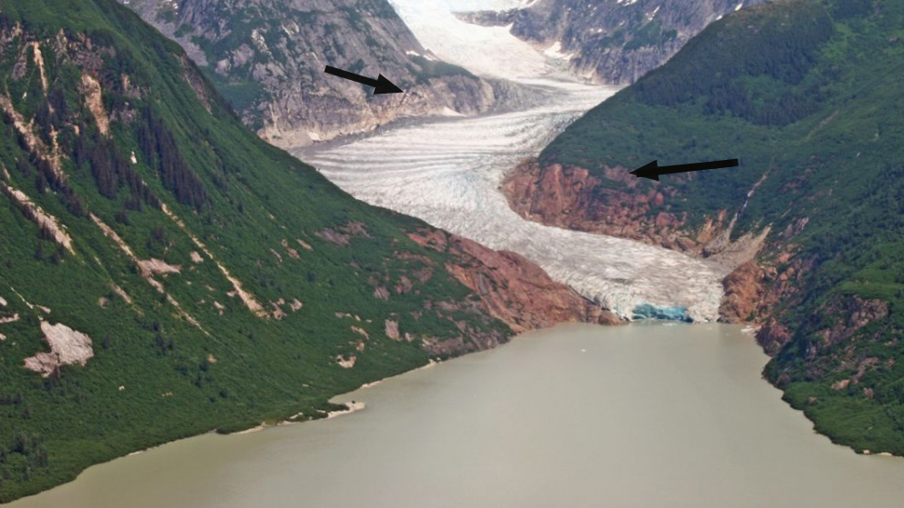
2015 Wings Airways image
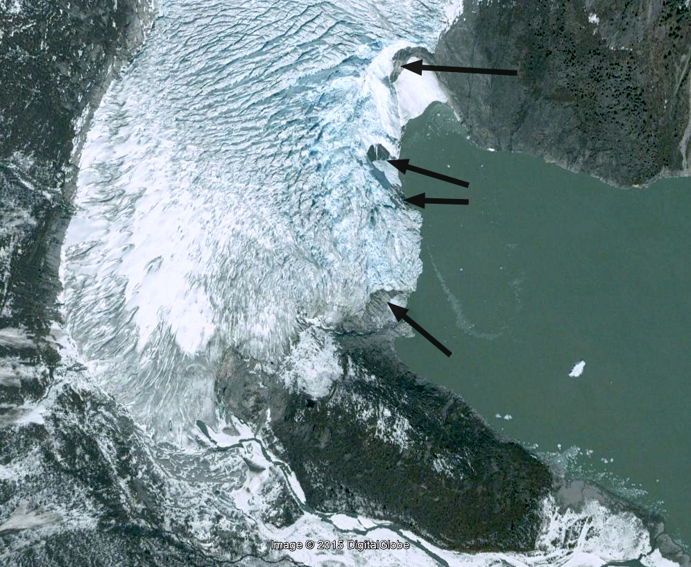
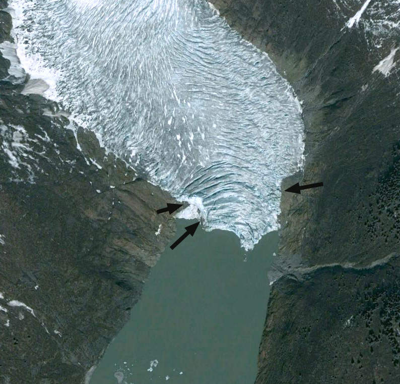
The East Twin is the narrower glacier and drops more quickly in elevation. The glacier has retreated 900 m from 1984 to 2015. The terminus has calved into Twin Lake for over a century, but in 2015 the width of the terminus calving into the lake has declined to 150 m from 600 m in 1984. The bedrock exposed on either side of the terminus indicates the terminus is on the verge of retreating from the lake. The black arrows indicate both bedrock at the glacier front, but also the trimlines left from recent thinning. The Google Earth image from 2006 and the 2015 image from the Wings Airways five glacier seaplane discovery tour.
In 2015 the snowline was particularly high, the accumulation zone usually covers the entire reach of the broad high elevation accumulation zone, not the pockets indicated by the purple dots. The declining mass balance identified by the Juneau Icefield ongoing mass balance program, which the high snowlines is indicative of is what is driving the retreat (Pelto et al, 2013).
Google Earth Image
Wings Airways Image

August 2015 Landsat image of Twin Glacier. The purple dots outline the accumulation zone where snowpack was retrained from 2015.
 Dean of Academic Affairs at Nichols College and Professor of Environmental Science at Nichols College in Massachusetts since 1989. Glaciologist directing the North Cascade Glacier Climate Project since 1984. This project monitors the mass balance and behavior of more glaciers than any other in North America.
[…] Twin Glacier, Alaska Retreats from Twin Lake https://blogs.agu.org/fromaglaciersperspective/2015/12/03/twin-glacier-alaska-retreats-twin-lake/ […]