
August 26, 2015
Barskoon Mountain Glacier Widespread Retreat, Tien Shan Range, Kyrgyzstan
Posted by Mauri Pelto
Farinotti et al. (2015) used three approaches to assess glacier change in the Tien Shan from 1961 to 2012. The results converge on an overall loss of glacier area of 19-27%,a spatial extent of 2960 square kilometers of glacier area. They further observe that it is primarily summer melting that has driven the change. Here we examine the change of several glaciers in a small sub-range in the Barskoon Mountain area of Kyrgyzstan using Landsat images from 1990-2013.. The A364 road extends up the Barskoon valley and was part of the silk road. It is now more widely used as the main road to the Kumtor Gold Mine (Colgan, 2015).

Google Earth image of Tien Shan Mountains and glaciers in Kyrgyzstan, study area is Barskoon Mountains.
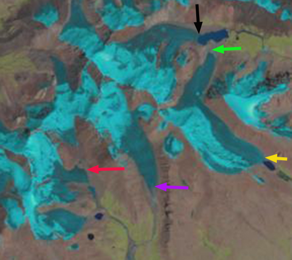
In 1990 working clockwise from the black arrow, which indicates two glaciers merging and then ending in a proglacial lake. At the green arrow is a third glacier that now terminates short of this developing lake. At the yellow arrow a fourth glacier terminates in a small proglacial lake. At the purple arrow a glacier ends in a valley lacking any lake. At the red arrow the glacier expands into a broad terminus lobe in a valley with two small lakes both north and south of the terminus. By 1997 the lake at the black arrow has extended as the glacier terminating in it has retreated. The glacier at the green arrow terminates further from the lake. At the red arrow the terminus lobe is much thinner. By 2013 the two glaciers that terminated in the lake have now receded from the lake with a total retreat of 400-500 m since 1990. At the green arrow the glacier now terminates 600 m from the lake instead of 300 m in 1990. At the yellow arrow the glacier no longer reaches the lake it had terminated in. At the purple arrow a new 200 m long lake has formed. The most dramatic change is at the red arrow where the terminus tongue is only 30% of the area it was in 1990. All of these are unnamed glaciers, and each like those adjacent without arrows indicating specific changes have been retreating and losing area. The typical length of these glaciers is 2-4 km, and those indicated have lost at least 10% of their length from 1990 to 2013. This is a sustained loss of mass balance, on glacier that do not experience any calving losses. The changes are similar for larger glaciers in the Tien Shan such as Petrov Glacier.

1990 Landsat image
1997 Landsat image
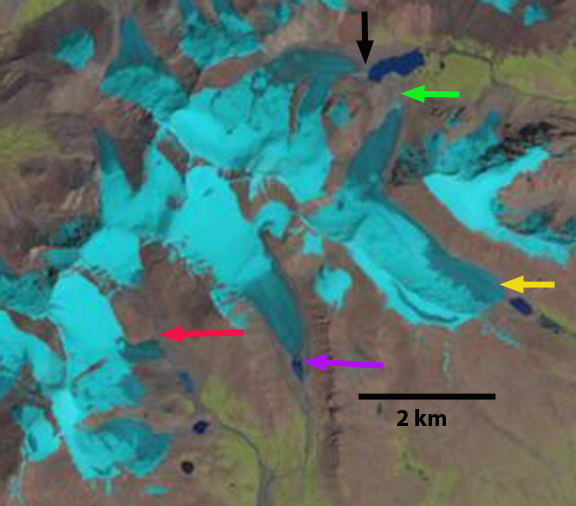
2013 Landsat Image
 Dean of Academic Affairs at Nichols College and Professor of Environmental Science at Nichols College in Massachusetts since 1989. Glaciologist directing the North Cascade Glacier Climate Project since 1984. This project monitors the mass balance and behavior of more glaciers than any other in North America.