
June 19, 2015
Slender Glacier, Brooks Range, Alaska: Rapid Retreat 1992-2014
Posted by Mauri Pelto
Slender Glacier is not an official name, but a well suited name to this glacier in the Romanzof Mountains of the Brooks Range of Northern Alaska. It is adjacent to the Okpilak Glacier and drains into the Okpilak River, which is host to arctic grayling. Here we examine Landsat imagery from 1992-2014 to identify changes. U-Alaska-Fairbanks has an ongoing program in the nearby Jarvis Creek Watershed examining in part how will the anticipated future increase in glacier wastage and permafrost degradation affect lowland hydrology. Matt Nolan (U-AK-Fairbanks) reports on changes of nearby McCall and Okpilak Glacier. These glacier have suffered increased mass loss since 1990 as a result of an increase in the equilibrium line altitude that has reduced accumulation area and is indicative of increased ablation (Delcourt al , 2008)
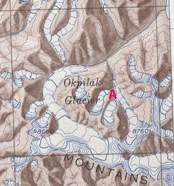
USGS 1951 map
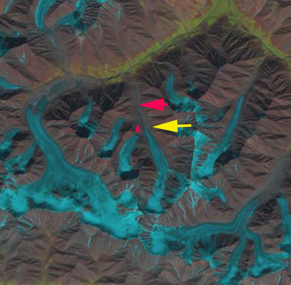
In 1992 the glacier extended downvalley to the red arrow at 1530 m. The glacier also received contribution from a tributary glacier at Point A. By 2002 the glacier had receded a short distance from the red arrow and still received input from the tributary glacier at Point A. By 2013 the glacier had receded to the yellow arrow 1100 meters from the 1992 terminus position, and now terminates at an altitude of 1675 m. The tributary glacier is no longer connected to Slender Glacier at Point A. The percent of snowcover is better than on Okpilak Glacier immediately to the west, or East Okpilak Glacier to the southeast. The first tributary entering the glacier on the east side is also disconnecting from Slender Glacier. In 2014 the Landsat image is after a light snowfall that has endured only on the glacier ice, helping outline the glaciers. The continued decline in retained snowfall and contributed snowfall from tribuatry glaciers will lead to an even more slender glacier.

1992 Landsat Image

2002 Landsat Image
2013 Landsat Image
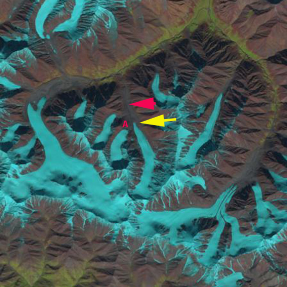
2014 Landsat Image
Google Earth images from 2006 and 2012 indicate a rapid retreat of the thin main terminus, and the loss of contact with the tributary glacier at Point A. The retreat is similar to that of Fork Glacier and Romanzof Glacier in the same region. The retained snowcover in 2012 is minimal on Slender Glacier and its tributaries. Tributary A lost almost all snowcover in 2012 and 2013 suggesting a lack of a consistent accumulation zone, which a glacier cannot survive without (Pelto, 2010)
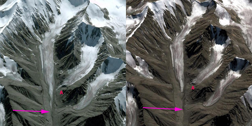
2006 Google Earth Image and 2012 Google Earth image
 Dean of Academic Affairs at Nichols College and Professor of Environmental Science at Nichols College in Massachusetts since 1989. Glaciologist directing the North Cascade Glacier Climate Project since 1984. This project monitors the mass balance and behavior of more glaciers than any other in North America.