June 15, 2015
Kokanee Glacier Spring 2015 Assessment, British Columbia
Posted by Mauri Pelto
Guest Post by Ben Pelto
Kokanee Glacier is located in the Selkirk Mountains of southeastern B.C., 30 km northeast of Nelson in Kokanee Glacier Provincial Park. Kokanee Glacier drains into the Joker Lakes, the uppermost of which are turquoise due to glacier flour input. Joker Creek carries the water downstream, eventually feeding into the Kootenay Lake and the Kootenay River, which flows to meet the Columbia River in Castlegar, B.C. In the last few years a decline in the number of fish inventoried in feeder streams to the lake caused cancellation of the Fishing Derby in 2015. The Meadow Creek spawning channel usually supports 500,000 to one million kokanee spawners, declined to less than 200,000 annually. In fall 2014, their numbers were down to 60,000. A drop of snow melt from this glacier also would pass through 16 hydroelectric facilities before reaching the ocean.
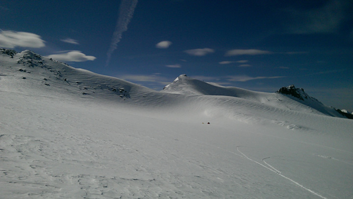
Kokanee Glacier looking west towards camp. April 20th, 2015 Photo: Ben Pelto
A research team from the University of Northern British Columbia and the University of Calgary began visiting the glacier each spring and fall beginning in 2013. Fall access to the glacier is via the Gibson Lake trailhead, which is a 7.5 km hike to Kaslo Lake and the new Kokanee Glacier Cabin (Slocan Chief cabin is only 1 km farther up the trail, but is no longer in use as a backcountry cabin). Spring access is via helicopter under a research permit. The Kokanee Glacier is north-facing and extends from 2800 meters at the summit of Kokanee Peak, to 2230 m where it terminates in an unnamed lake. This lake is a recent addition to the Joker Lakes, due to glacier retreat in the past two decades. The Kokanee Glacier covers about 1.7 km2.
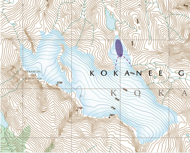
Contour map of the Kokanee Glacier, with the uppermost Joker Lake. Approximate current terminus position purple-dashed line. Oval indicates new proglacial lake.
Our spring visit to the glacier documented snowpack deposited during an anomalously warm winter, as shown in the image below from the North American Freezing Level Tracker. The tracker is run by Idaho State University and estimates freezing levels based on the NCEP/NCAR Global Reanalysis, which is determined every six hours. Freezing level is the elevation where air temperature is 0°C at a given time. Freezing levels are important to mountain hydrology and determine whether precipitation falls as rain or snow, the elevation of the rain/snow line, whether the ground is frozen when snow falls in the autumn, the efficiency of snowpack accumulation through the winter (melt events, rain on snow), the internal temperature of the snowpack (which drives melt and metamorphosis of the snowpack), and the length of snow free season at a given elevation. What is immediately apparent is that freezing levels were elevated throughout the accumulation season, which generally begins in late September. Freezing levels were highest relative to the median in the key winter months of January through March. Local skiers and ski guides complained of rain during many storms, which reached to or near the mountain tops and left poor skiing conditions.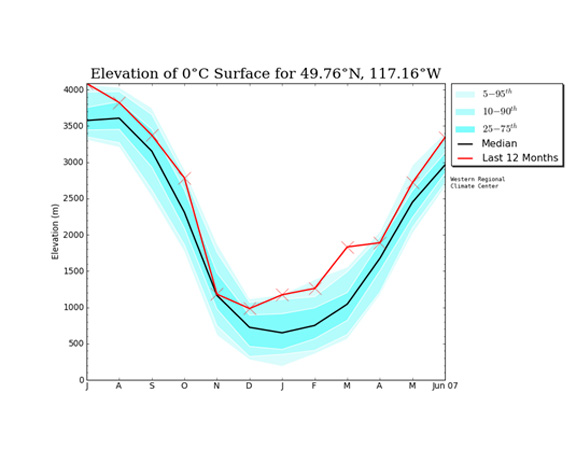
Estimated freezing levels for Kokanee Glacier for July 2014 to June 2015 North American Freezing Level Tracker
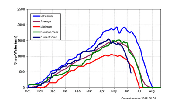
The Redfish Creek snow pillow is the nearest snow pillow site (see below), and is located 7 km southeast of the glacier at 2086 m. The Kokanee Glacier extends from around 2230 m to 2800 m so the snow pillow site may not accurately represent the amount and type of precipitation on the glacier. Regardless, this winter featured a fairly average snowpack, generally hovering above the mean SWE (snow water equivalent), which is calculated from 2001, when the gauge was installed, to present. A precipitous drop in SWE marked an early and strong start to the melt season, with maximum snowpack coinciding with our visit (April 19-21, 2015), roughly two weeks ahead of the usual SWE maximum date (in the first week of May) as seen by the purple line.
Redfish Creek snow pillow site of the B.C. River Forecast Center for 2014-2015.
The primary goal of our trip was to assess winter accumulation. Our measurements consisted of probing snow depth and digging snow pits. We took 80 probe measurements at 20 locations, and dug two snow pits, one at 2475 m and one at 2675 m. While snow depth was lowest near the terminus at 3 to 3.5 m, there was no correlation between elevation and accumulation from 2300 m and above, which accounts for a majority of the glacier area. Above 2300 m, snow depth ranged from 4.3 to 6.3 m with an average of 4.8 m.
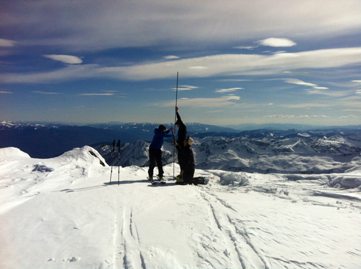
Probing snow depth on the Kokanee Glacier, April 20th, 2015. Photo: Alison Criscitiello.
Our measurements revealed that this year’s snow pack was a dense one, likely due to mid-winter melt events, rain-on-snow events, and increased temperature during snow events. Given that snowpack was low across B.C. in the winter of 2014-2015, it would have been reasonable to assume that the glacier fared poorly. However, the winter balance was precisely halfway between the healthy winter balance of 2013 and the weak winter balance of 2014. Our data indicate that freezing levels played a large role in this year’s snowpack for the Kokanee Glacier given that the surrounding region is below 50% of normal snowpack, yet the glacier is much closer to normal as it was still above even the high 2015 winter freezing levels. Given our limited sample size, with this being the third measured winter accumulation, it is beyond the scope our data to assess how close to or far from normal this winter’s snowpack was for the Kokanee Glacier.
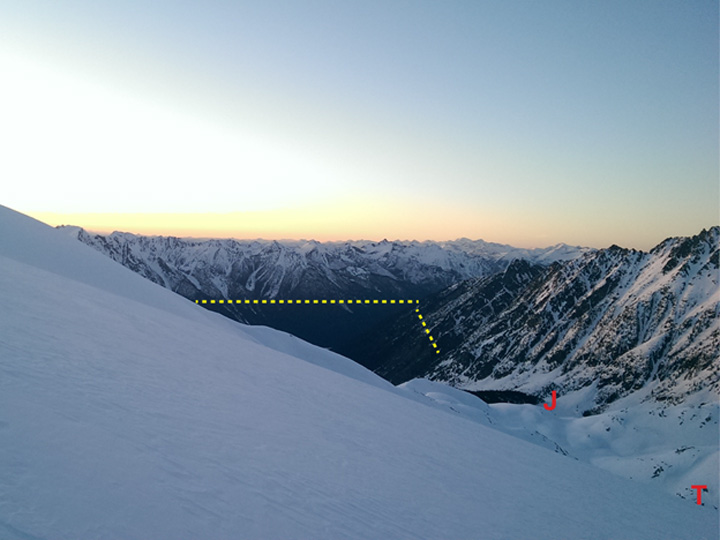
Standing on the glacier looking down valley, we observed that bare ground began around 1800 m where there should have still been a couple meters of snow. This highlighted the stark contrast between high and low elevations. Clearly, rain dominated below 1800 m this winter. This winter may be a potential model for the immediate future climate, where increased winter temperatures lead to a higher snowline, lower snowpack at lower elevations, and near average snowpack at higher elevations. Given the early start to fire season in B.C. and the Yukon, similar winters will come at a high cost for fire fighting, forest productivity, and water resources.
View looking west from Kokanee Glacier April 19, 2015. Approximate snow line yellow dashed line ~1800 m. Red J indicates location of uppermost Joker Lake. Red T is just beyond the terminus, which cannot be seen due to the slope. Photo: Ben Pelto
4.5 m deep snow pit at 2675 m on the Kokanee Glacier, April 20th, 2015. Photo: Alison Criscitiello.
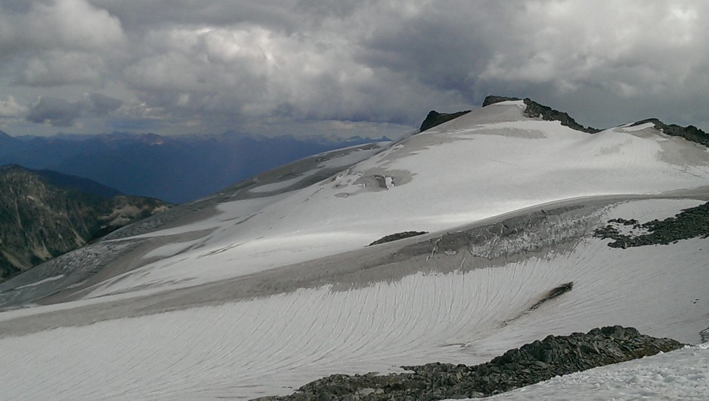
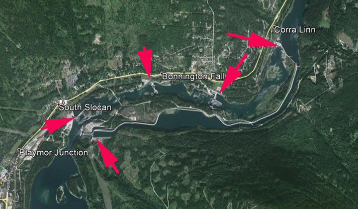
The B.C. River Forecast Center releases a monthly snow report, and stated that temperatures in the Kootenay Region, where the Kokanee Glacier is located, were 3 to 5°C above average. The image below shows that by May 1, snowpack was 67% of average. The June 1st map has all but three sub-regions of B.C. exhibiting less than 50% of normal snowpack, with the West Kootenay region at 30% of normal. The result will be less snowpack across southern BC this summer. At the end of August last year there was considerable bare ice and firn exposed on Kokanee Glacier, this year we anticipate even more upon our return at the end of the melt season. Of course the snow report is critical for hydropower in BC. For the Kokanee Glacier, meltwater goes through a series of hydropower dams on the Kootenay River.
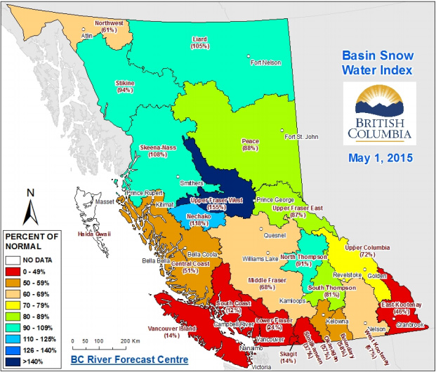
May 1, 2015 Snow Report Map, B.C. River Forecast Center. Kokanee Glacier located by Nelson in SE B.C.
Kokanee Glacier, Aug. 27th 2014. the darker areas are either firn that has survived more than one summer or bare glacier ice.
Kootenay River Hydropower.



 Dean of Academic Affairs at Nichols College and Professor of Environmental Science at Nichols College in Massachusetts since 1989. Glaciologist directing the North Cascade Glacier Climate Project since 1984. This project monitors the mass balance and behavior of more glaciers than any other in North America.