
May 13, 2015
Retreat of Grewingk Glacier, Alaska 1986-2014
Posted by Mauri Pelto
Grewingk Glacier drains west toward the Kachemak Bay, Alaska terminating in a proglacial lake in Kachemak Bay State Park. The glacier drains an icefield on the Kenai Peninsula, glaciers draining west are in the Kenai Fjords National Park. The glaciers that drain east toward are in the Kenai Fjords National Park, which has a monitoring program. Giffen et al (2008) observed the retreat of glaciers in the region. From 1950-2005 all 27 glaciers in the Kenai Icefield region examined are retreating. Giffen et al (2008)observed that Grewingk Glacier retreated 2.5 km from 1950-2005. Here we examine Landsat imagery from 1986-2014 to illustrate the retreat of the glacier. The icefront continues to calve into the expanding pro-glacial lake.
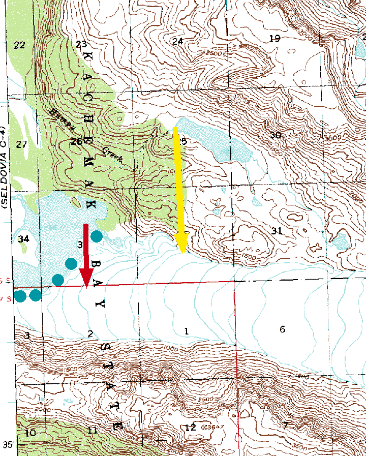
1951 based USGS Topographic map Seldovia C-3
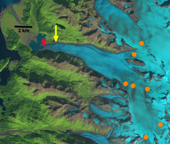
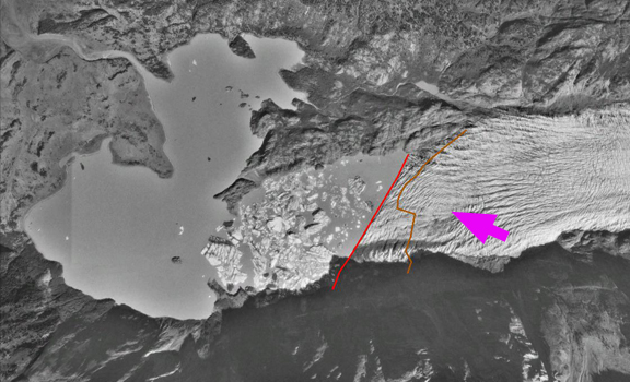
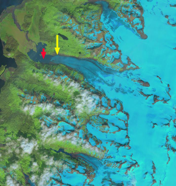
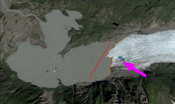
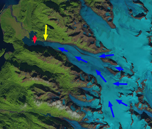
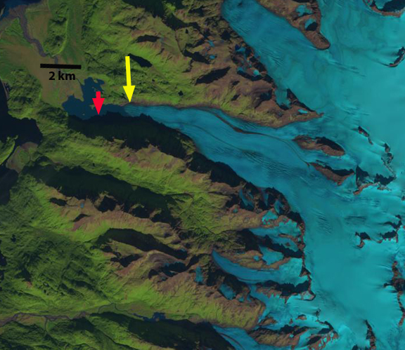
The red arrow is the 1986 terminus location at the midpoint, the yellow arrow is the 2014 mid-point terminus location. In 1951 the glacier extended beyond the peninsula at the red arrow into the wider portion of the lake. By 1986 the glacier had retreated into the narrow section of the lake extending east into the mountains, the southern margin of the terminus is further advanced than the northern margin. The orange dots indicate discoloration of the glacier surface from volcanic ash deposited on the glacier surface from Augustine Volcano in 1986. In 1989 there is not a marked change. In a 1996 Google Earth image, there is considerable icebergs indicating a recent collapse of a section of the terminus. The pink arrow indicates concentric crevasses, indicating a depression, the red line is the terminus in 1996 and the brown line the 2003 terminus.
By 2001 the terminus has retreated m, and the glacier front is now oriented north-south across the lake. In 2003 the depression from 1996 now has a small supraglacial lake, the terminus has retreated 500 m on the southern margin and 200 m on the northern margin. In 2013 the glacier has retreated an additional 600 m and the southern margin has now receded further upvalley than the northern margin. Blue arrows indicate direction of glacier flow. By 2014 the glacier has retreated 1.4 km since 1986, 50 m per year. There is an increase in the glacier slope 2.5 km above the terminus where crevassing increases. This suggests the lake will end by or at this point, which would then lead to a reduction in retreat rate.
This retreat follows that of Pederson Glacier, Four-Peaked Glacier and Spotted Glacier. The continued reduction in glacier size leads to changes to the Kachemak Bay estuary. Kachemak Bay is the largest estuarine reserve in the National Estuarine Research Reserve System. It is one of the most productive, diverse estuaries in Alaska, with an abundance of Steller sea lions, seals, sea otters, five species of Pacific salmon, halibut,herring, dungeness crabs and king crabs (NERRS, 2009). The estuary salmon fishing industry is, one of Kachemak Bay’s most important resources and livelihoods.
1986 Landsat Image

1989 Landsat Image
1996 Google Earth Image
2001 Landsat Image
2003 Google Earth Image
2013 Landsat Image
2014 Landsat Image
 Dean of Academic Affairs at Nichols College and Professor of Environmental Science at Nichols College in Massachusetts since 1989. Glaciologist directing the North Cascade Glacier Climate Project since 1984. This project monitors the mass balance and behavior of more glaciers than any other in North America.
[…] and sea lettuce, colonize the beach face creating multi-colored patterns. Read more here and here. Download the latest version of the CoastView app and explore more of Grewingk Creek […]
[…] a tsunami that swept the forefield of Grewingk Glacier in the fall of 1967. Read more here and here. Download the latest version of the CoastView app and explore more of Grewingk Glacier […]