
February 26, 2015
Mahsa Icefield Retreat and Separation, Baranof Island, Alaska
Posted by Mauri Pelto
The Mahsa Icefield is at the headwaters of Takatz Creek. This is a small glacier, not an actual icefield. Five kilometers to the west is another small unnamed glacier at the headwaters of Sawmill Creek. Here we focus on changes in the two glacier using Landsat images from 1986 to 2014.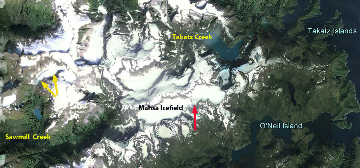
Google Earth image
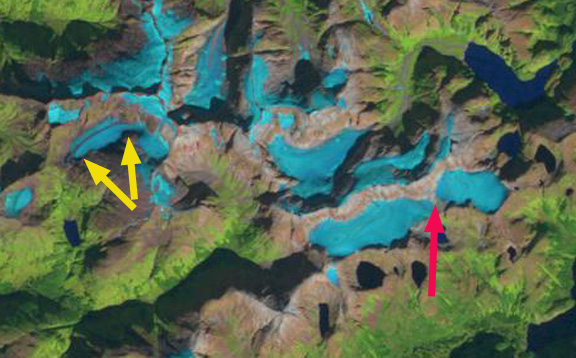
In 1986 the Mahsa Icefield is a contiguous glacier that extended 5 km from east to west, red arrow indicates the mid-section of the icefield. A separate glacier in Sawmill Creek, yellow arrows, was 2.1 km long and has no lake at its terminus. In 1997 the Mahsa Icefield has separated into an east and west half, at the red arrow, and has lost all of its snowcover. The glacier in Sawmill Creek is still a single ice mass, but has lost all of its snowcover, which happened in 1998, 2003 and 2004. In 2014 the Mahsa Icefield’s east and west half are separated by 300 m, red arrow. There is very little snowcover remaining despite there is a month left in the melt season. At the headwaters of Sawmill Creek a lake has formed as the glacier has retreated, the lake is 600 m long in 2014. The glacier has also separated into a small upper and lower section. This glacier has lost half of its area since 1986. The retreat of these glaciers on Baranof Island is similar to the retreat of nearby Carbon Lake Glacier,Lemon Creek Glacier, and Sinclair Glacier. Lemon Creek Glacier has lost more than 25 m of glacier thickness during the 1953-2014 period when its mass balance has been observed by the Juneau Icefield Research Program, and has retreated more than 1 km (Pelto et al, 2014).

Landsat image 1986
Landsat Image 1997
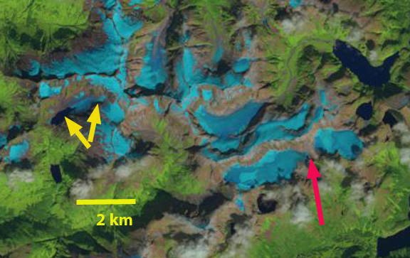
Landsat image 2014
 Dean of Academic Affairs at Nichols College and Professor of Environmental Science at Nichols College in Massachusetts since 1989. Glaciologist directing the North Cascade Glacier Climate Project since 1984. This project monitors the mass balance and behavior of more glaciers than any other in North America.
Thanks for writing about these Baranof Island glaciers (here and in your previous post on the Carbon Lake glaciers), I really appreciate the chance to learn a more about my home area. I am curious about the name “Mahsa Icefield”, as it’s not a name I’ve heard at all locally. If you know any more about where it came from, I would be very interested to know.
Also, in case you are interested, there was a college student GIS project that looked at the retreat of the smaller glacier you talked about in this post. (One of the authors had grown up here in Sitka). It can be downloaded from the Dartmouth webservers here:
http://dujs.dartmouth.edu/wp-content/uploads/2012/11/quantifying-glacier-retreat-on-baranof-island.pdf
[…] I’ve been following a weblog called From a Glacier’s Perspective for some time, and had been particularly interested in the posts about glaciers in Southeast Alaska. I recently left a comment to request the author take a look at Baranof Island glaciers, and he graciously did so, writing a post on Carbon Lake glacier retreat and the Mahsa Icefield retreat and separation. […]