
February 16, 2015
Chickamin Glacier Retreat, North Cascade Range, Washington
Posted by Mauri Pelto
Chickamin Glacier covers the north slope of Sinister Peak in the North Cascade Range of Washington. The glacier has a valley tongue that descends to an outwash plain. Here we examine retreat of the glacier from 1979 to 2012. The glacier had advanced from 1955-1975, before commencing retreat.

Chickamin Glacier (John Scurlock 2004 Aerial shot, https://pbase.com/nolock/image/49374401)
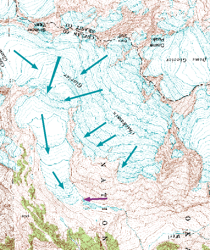
USGS Map of Chickamin Glacier
In 1979 the glacier terminus was at the pink arrow, several hundred meters beyond a prominent buttress, red arrow, where the glacier turns west. The lowest icefall is indicated by a green arrow. In 1991 the glacier has retreated from the pink arrow, but still is turning the corner beyond the buttress. The lower icefall is still extensively crevassed. By 1998 in a Google Earth image the terminus is outlined with yellow dots and has retreated 230 m from the 1979 position. The lower icefall is still crevassed. By 2005 in a photograph from Tom Hammond (North Cascades Conservation Council), the glacier has retreated to the buttress. in a 2006 Google Earth image the terminus position is indicated by yellow dots, with a retreat of 50 m since 1998. The lower portion of the glacier has limited crevassing. In the 2012 image the glacier terminus no longer reaches the buttress and has retreated 360 m since 1979. We observed exceptional ablation conditions in the North Cascades in 2013 and 2014, which combined with exceptionally low snowpack in 2015 will lead to a continued significant retreat of this glacier. The crevassing in the lowest icefall has declined and is now superficial. All 47 glaciers observed by the North Cascade Glacier Climate Project have been retreating and four have disappeared (Pelto, 2011). This glacier is similar in size and retreat to Boston Glacier and Honeycomb Glacier.
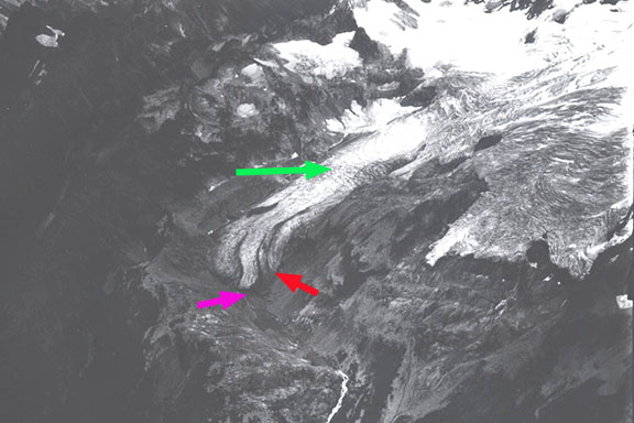
Chickamin Glacier 1979 (Austin Post)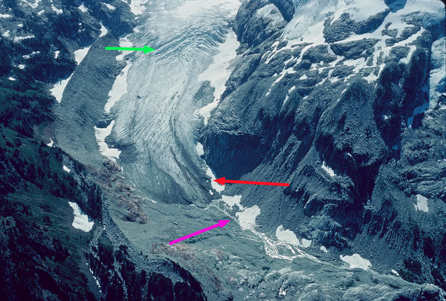
1991 Chickamin Glacier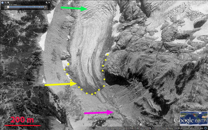
1998 Google Earth image
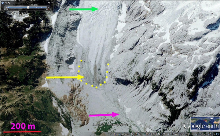
2006 Google Earth image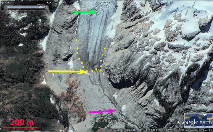
2012 Google Earth Image
 Dean of Academic Affairs at Nichols College and Professor of Environmental Science at Nichols College in Massachusetts since 1989. Glaciologist directing the North Cascade Glacier Climate Project since 1984. This project monitors the mass balance and behavior of more glaciers than any other in North America.
The aerial images of the Chickamin Glacier posted here that are attributed to Tom Hammond were actually taken by me, John Scurlock, on July 22, 2004. Please correct the attribution.
Link to the image as posted on my website: https://pbase.com/nolock/image/49374401
The AGU has permission to use my images, provided the correct attribution accompanies the image.
Thanks,
John Scurlock