
April 3, 2014
Kangiata Sermia, Retreat Southwest Greenland
Posted by Mauri Pelto
Kangiata Sermia is an outlet glacier in Southwest Greenland that empties into the Kangersunaq fjord east of Nuuk. Thomas et al (2009) noted that Kangiata Glacier thinned most notably near its terminus decrasing up glacier to negligible thinning 30 km inland. They further found that the glacier bed was above sea level 40 km inland. Sole et al (2010) observed variations in the velocity of this glacier and found that there was a substantial spring speedup as the melt season began and then an even more significant slowdown for most of the summer. They noted that the net effect of the summer speed variations on annual motion is small (∼1%), indicating the lack of a meltwater induced overall acceleration. The velocity figure below is from Figure 4 of Ahlstrom et al (2013), indicating the annual velocity minimum is in late summer. Box and Decker (2011) noted that glacier retreated 100 meters/year from 2000 to 2010.
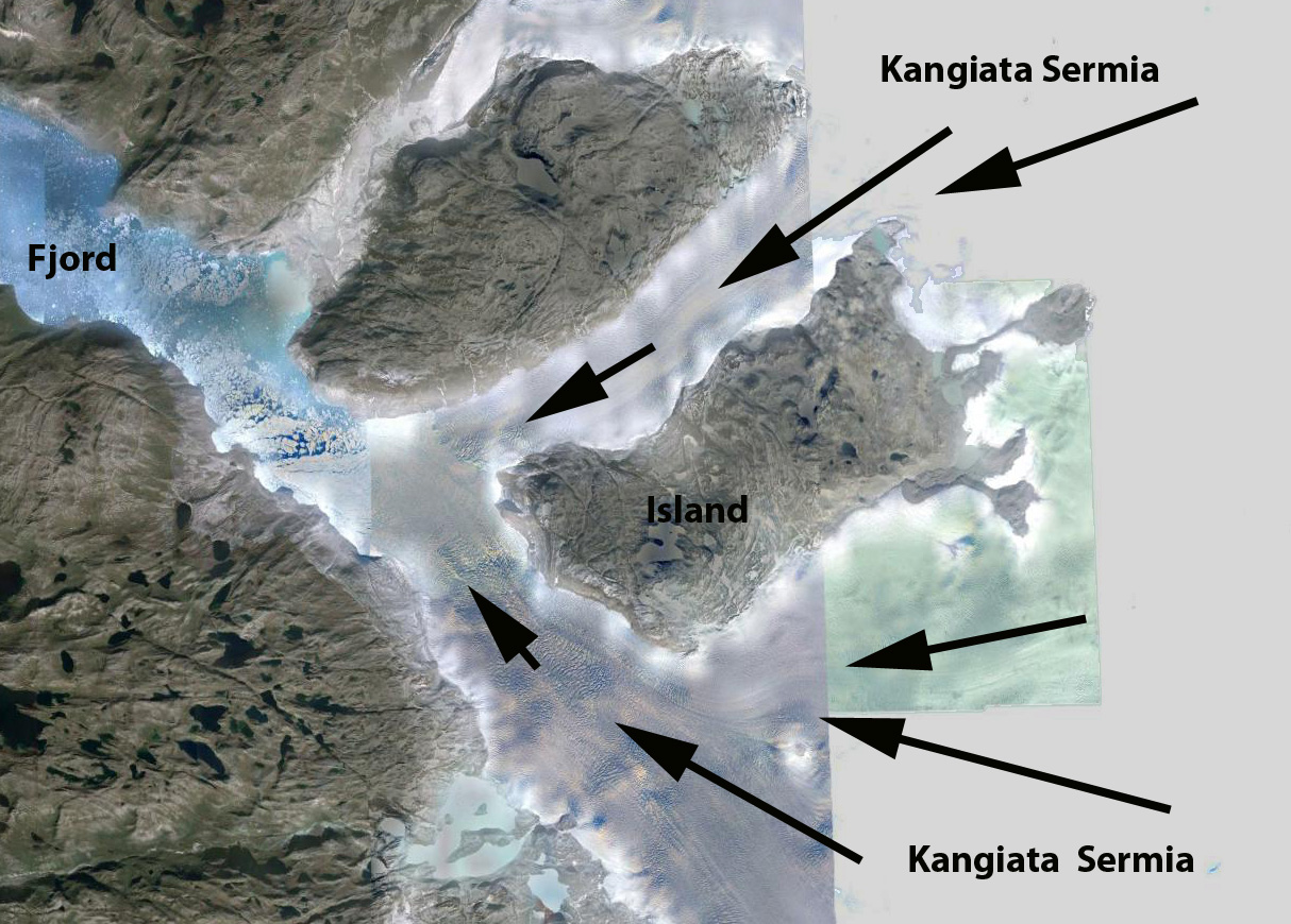
Google Earth image
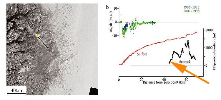
Thomas et al (2009) Figure showing the bedrock and surface profile of Kangiata Sermia
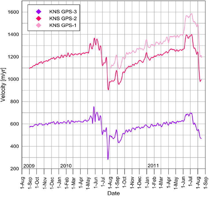
Ahlstrom et al (2013) Figure showing seasonal velocity change of Kangiata Sermia
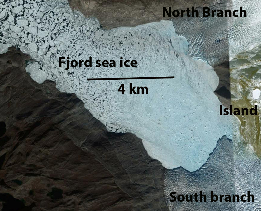
Here we examine Landsat imagery of the glacier from 1987 to 2013 to identify changes. In 1987 the two main termini of the glacier were joined, down fjord of an island that separates the two branches. The terminus in each image is indicated by red dots, the yellow arrow note an island in the middle of a peripheral ice dammed proglacial lake, the pink arrow a minor terminus on the north side of the island and the orange arrow a medial-lateral moraine comples extending into the glacier. By 2001 the glacier terminus has separated into two parts, with a retreat of jsut over 1 km in the 14 years. The proglacial lake is still full, yellow arrow. The upglacier minor terminus is developing a lake at its terminus as it retreats. The orange arrow indicates the expansion of the moraine complex as the glacier thins. By 2006 the main terminus has continued to retreat up the south side of the island 1.5 to 2 km since 2001. The proglacial lake level has declined and the island has become a peninisula. The thinning ice is simply not able to impound as deep or large a lake. The minor terminus at the pink arrow has developed a lake that is over 1 km long. In 2013 the changes from 2006 are limited, the moraine complex has continued to expand. The overall retreat from 1987 to 2013 is 3 km. The retreat is similar to that of Narssap Sermia , Kuussuup Sermia, and Qaleraliq as each responds to the climate warming. The lake is a bit larger, though the lake does fluctuate through an annual cycle filling and draining. Google Earth imagery indicates the lake at an even lower level, it no longer fills to nearly the level of 2001. This lake is similar to Tiningnilik in its size and location, but has lost more of its volume. The lake at the pink arrow is 1.2 km long. Each winter the fjord in front of the glacier freezes and the terminus protected from calving can advance. The Google Earth closeup image indicates the heavily crevassed nature of both termini indicative of rapid flow. On April 2, 2014 the fjord is quite filled with sea ice to the southeast bend 50 km from the terminus. The terminus is not distinct in this particular image. 
1987 Landsat image
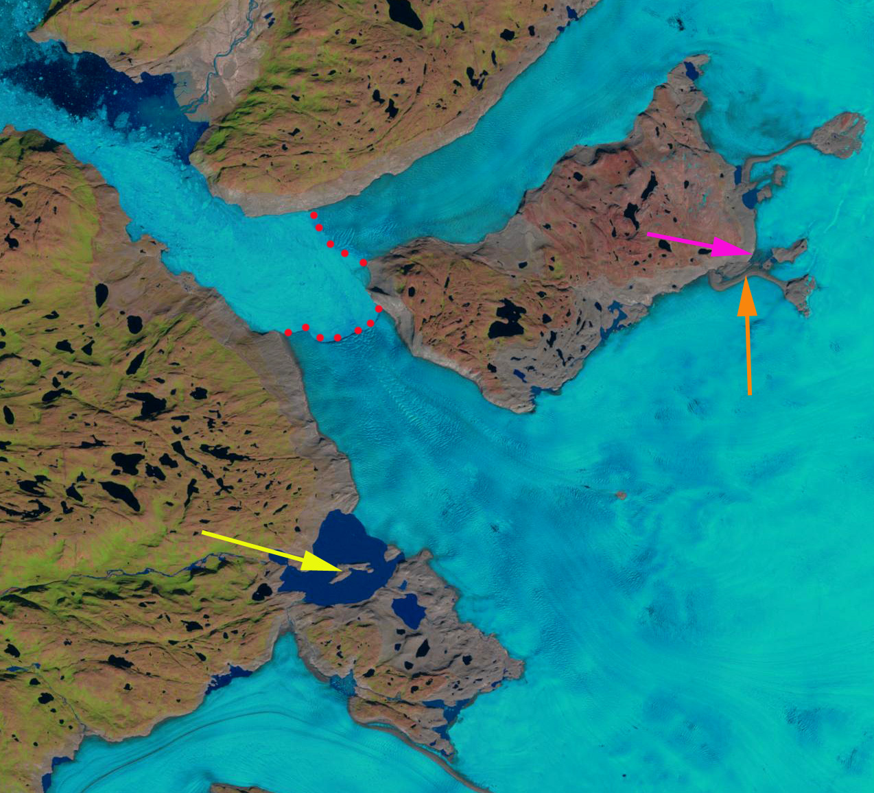
2001 Landsat image

2006 Landsat image
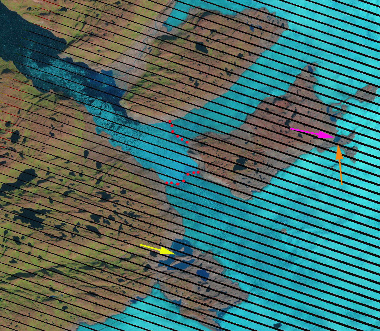
2013 Landsat image
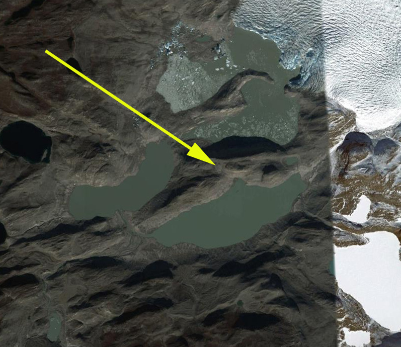
2012 Google Earth image
2012 Google Earth image

April 2 2014 MODIS Image
 Dean of Academic Affairs at Nichols College and Professor of Environmental Science at Nichols College in Massachusetts since 1989. Glaciologist directing the North Cascade Glacier Climate Project since 1984. This project monitors the mass balance and behavior of more glaciers than any other in North America.