
October 8, 2013
Eyjabakkajökull Retreat, Iceland
Posted by Mauri Pelto
Eyjabakkajökull is a surging glacier that emanates from the north side of Vatnajokkull Ice Cap. The glacier surged in 1890, 1931, 1938 and 1972. During the latter advance the glacier advanced approxmately 2 km (Ívar Örn Benediktsson, 2009). A recent project focused on this glacial geology in front of this glacier led by Ólafur Ingólfsson and Ívar Örn Benediktsson (University of Iceland) and Dr. Frank Lisker (University of Bremen). The information was put together by Antje Herbrich. The first image is a map from this project indicating the glacier moraines emplaced by the four most recent surges. It is apparent that each surge has not extended as far as the previous surge. In the second image also from the Eyjabakkajökull project, the blue line is the 1973 terminus and the purple line the 1991 terminus position drawn on a 2000 Landsat image. 

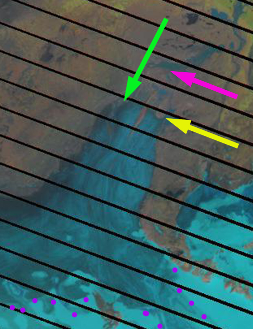
Here we examine Landsat Imagery from 1999, 2012 and 2013 and Google Earth imagery in 2000. The glacier tongue has a prominent medial moraine ridge that in 1999 ended just short of the outlet river in a stretch where it ran west to east, pink arrow. This is a ridge because it is an ice cored moraine, as the ice core melts the ridge disappears. By 2012 the glacier had retreated 2 km from the 1999 terminus, and ending at the yellow arrow. This distance is emphasized by the length of the green line to the terminus. The green line starts from a specific lake and terminates at the glacier. In 2013 the 2 km retreat since 1999, and the 1.1 km retreat from 1972-1999 places the terminus about a kilometer behind the terminus location prior to the 1972 advance. The 1972 terminus is marked with a red arrow. The current terminus has a very low slope and limited crevassing indicating that a rapid retreat will continue. Hence, when the next surge comes, it will begin from quite a recessed position and will fell well short of the 1972 advance moraines. The snowline in 2012 and 2013 is above 1100 m, purple dots, which is high enough to indicate significant negative mass balance.

1999 Landsat image

2000 Google Earth
2012 Landsat image

2013 Landsat image
This retreat is similar to that of draining the Tungnaarjökull west side of Vatnajokulland Skeiðarárjökull Glacier on the south side and Brúarjökull . The low slope is seen in the image below looking across the glacier from Ívar Örn Benediktsson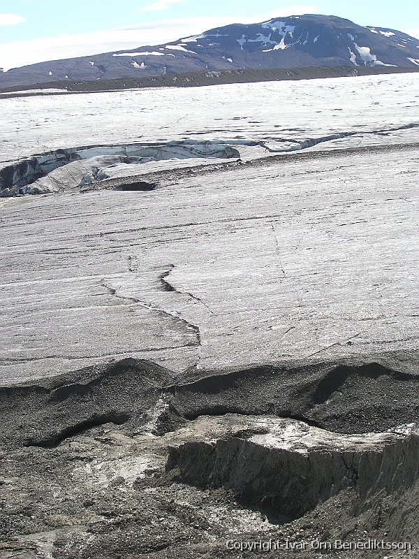
 Dean of Academic Affairs at Nichols College and Professor of Environmental Science at Nichols College in Massachusetts since 1989. Glaciologist directing the North Cascade Glacier Climate Project since 1984. This project monitors the mass balance and behavior of more glaciers than any other in North America.