
April 18, 2013
Laramcota Glacier Retreat, Bolivia
Posted by Mauri Pelto
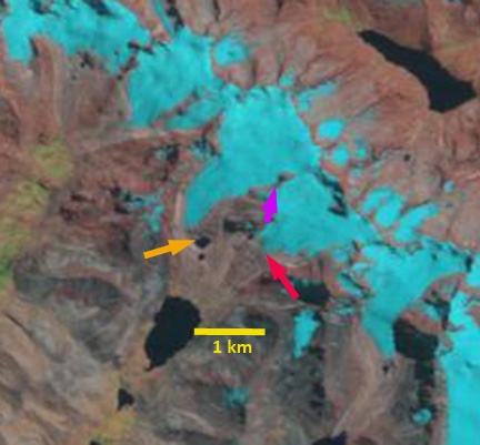
Laramcota Glacier is in the Cordillera Tres Cruces of Bolivia. The glacier feeds into Laguna Laramcota and eventually the Rio Boopi, Rio Beni and finally the Amazon River. The glaciers of Bolivia have received much less scrutiny than those in Peru or Chile, but are quite numerous. Riberio et al (2005) noted a 32% loss of glacier area inn the Tres Cruces from 1972-1999 using satellite imagery. Melocik (2010) in a preliminary report using remote sensing noted a 40% loss in Tres Cruces glacier area from 1985 to 2005. This is a quite a substantial loss, and is likely a maximum loss as some of the area lost at higher elevation could have been non-glaciated snow covered area. Here we examine the changes in Laramcota Glacier using Landsat imagery from 1988 and 2011. The 2.6 km long glacier flows west from 5600 meters to a terminus at 5000 meters. In 1988 the glacier ends at a small lake one kilometer upstream of Laguna Laramcota, orange arrow. The glacier just to the east ends just 600 meters from the Laramcota, red arrow. The ridge separating the two glaciers at the purple arrow is quite narrow. By 2011 the glacier has retreated 300 meters from the lake, orange arrow. The glacier just to the east has retreated 200-300 m as well. The ridge separating the glaciers has expanded considerably in width, purple arrow. The overall loss in glacier from 1988-2011 is 10-15%. The retreat of this glacier fits the pattern of other Bolivian Glaciers, such as the Zongo Glacier or Nevada Cololo and tropical Andean glaciers in general (Rabatel et al, 2013).
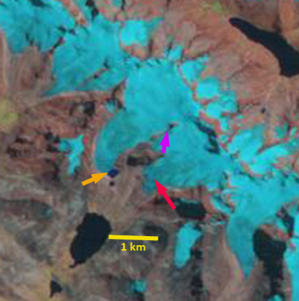
 Dean of Academic Affairs at Nichols College and Professor of Environmental Science at Nichols College in Massachusetts since 1989. Glaciologist directing the North Cascade Glacier Climate Project since 1984. This project monitors the mass balance and behavior of more glaciers than any other in North America.