October 29, 2012
Guyot Glacier Retreat, Icy Bay Alaska
Posted by Mauri Pelto
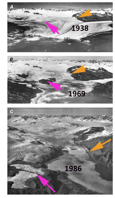
Guyot Glacier a century ago was joined with the Tyndall and Yahtse Glacier with an ice front that reached just beyond the entrance of Icy Bay. Today Guyot Glacier has retreated more than 50 km. This post examine satellite imagery from 1984-2010 to illustrate ongoing thinning and retreat of the Guyot Glacier. Guyot Glacier has retreated more than 50 km since 1904 (Molnia, 2007).  As retreat began the glacier had a calving front that was over 10 km long. The glacier was also calving into deep water. This led to a rapid retreat up to 1938 (USGS). In the sequence of images below from the USGS, this is evident. By 1969 the glacier had separated into three sections, middle image in sequence and by 1986 the Guyot Glacier had retreated a considerable distance up the newly exposed fjord. The pink arrow points to the Kashteen Peninsula that will emerge, and the orange arrow to the 1984 terminus position of Guyot Glacier.
  Barclay et al (2009) have illustrated the dynamic nature of this glacier that has had three large (40 Km+) advances and retreats in the last 4000 years. The Landsat image sequence is from 1984, 1995, 2000 and 2010. In each image the pink arrow indicates an area on the Kashteen Peninsula that was still covered by the glacier until 1980. In 1984 on Kashteen there are two ice masses with an area of 1.3 square kilometers, by 1995 one small ice mass of 0.3 square kilometers, by 2000 the stranded ice masses are gone. By 2010 the area is showing considerable vegetation development. This indicates a relatively short ecesis rate, rate of vegetation returning after deglaciation. The orange arrow indicates the 1984 terminus of Guyot Glacier. The green arrow is the 2010 terminus position of Guyot Glacier, the main terminus retreated 3.8 km during the 26 year period. The yellow arrow indicates the expansion of a bare bedrock region on the south side of the main Guyot Glacier terminus that now extends 2 kilometers from the margin. The red arrow is a separate terminus of an unnamed glacier that ended in Tsaa Fjord up to 2000, and is no longer tidewater, having retreated 400 meters from tidewater and 600 meters since 1984.
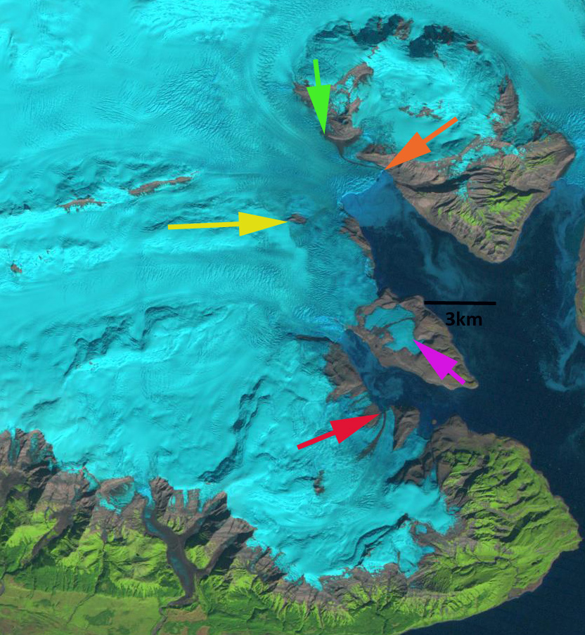
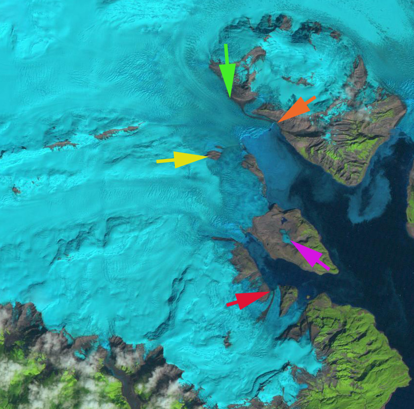
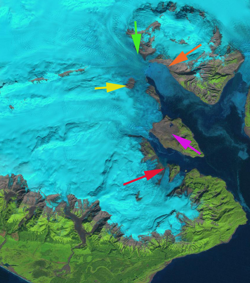
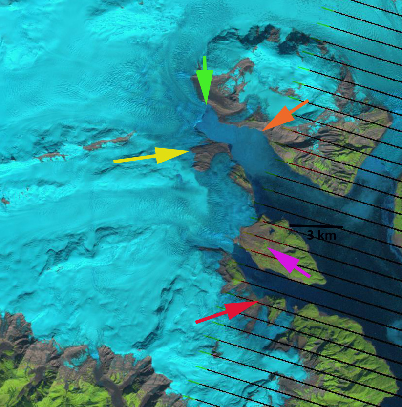 Tidewater glaciers have two means to lose mass calving and melting. The former can be insensitive to climate and is more dependent on water depth and calving width (Brown et al, 1982). Pelto (1987) and Viens (1995) produced models showing that climate acts as a first-order control on the advance/retreat cycle of calving glaciers during most of the advance retreat cycle, but there are climate insensitive periods of the tidewater glacier cycle too (Meier and Post, 1987). In the case of Guyot Glacier today the peripheral areas at the yellow and red arrows indicate considerable thinning in areas that are no longer calving and indicate that mass balance losses are still occurring without calving, hence, climate driven. For the main Guyot Glacier the current ratio of the accumulation area to the melt area is quite high. This is the accumulation area ratio, and it is high enough to be in equilibrium if calving is reduced. The Brady Glacier is at the other end of the cycle, just beginning a large retreat due to extensive thinning from recent reduced mass balance. Yakutat and Valdez Glacier are two nearby glaciers that have also experienced large calving retreats, though both still have large ablation (melt) areas.


 Dean of Academic Affairs at Nichols College and Professor of Environmental Science at Nichols College in Massachusetts since 1989. Glaciologist directing the North Cascade Glacier Climate Project since 1984. This project monitors the mass balance and behavior of more glaciers than any other in North America.