
June 5, 2012
Gietro Glacier Retreat and Hydropower, Switzerland
Posted by Mauri Pelto
Gietro Glacier may sound like a type of italian dessert, but this glacier has a deadly history. During periods of advance the glacier blocked off the valley of Mauvoisin. Failure of the glacier ice dam led to large flood events in 1595 and 1818 that lead to the loss of many lives in the valley below. Today the Mauvoisin Dam one of the 10 largest concrete arch dams in the world not only provides hydropower but also protection against this hazard. In 1818, an advance of the Gietro glacier, now retreated high above the reservoir, generated ice avalanches which blocked the flow of the river. When the ice barrier was breached, 20 million cubic meters of flood water was released devastating the valley (Collins, 1991).There are several other large glaciers in the basin Otemma, Mont Durand and Brenay that provide runoff to power what is today a large hydropower project. The Mauvoisin Dam can produce 363 MW of power, and typically provides 1030 millionKWh of power each year. The reservoir can store 200 million cubic meters of water. Erosion largely from the glaciers in the watershed produce enough sediment to cover the lake bottom with 60 cm of sediment per year (Loizeau, et al. 2010).

Mauvoisin Dam

Google Earth Image of Gietro Glacier region.
Gietro Glacier is one of the glaciers where the terminus is monitored annually by the Swiss Glacier Monitoring Network (SCNAT). The glacier advanced 150 m from 1962-1985. Retreat from 1985 to 2000 was 110 m or 7.5 m/year, accelerating to 350 m from 2004-2014, 35 m/year. This post focuses on comparison of a 1988 and 2014 Landsat image, 2001 terminus photograph from the SCNAT and 2009 Google Earth imagery. In 1988 the glacier terminates at the top of a steep cliff that is evident in the 1988 image, yellow arrow, 2014 terminates at pink arrow and dam is burgundy arrow. By 2001 the glacier has retreated to the first prominent joint feature, green arrow, on the north side of the glacier above the cliff, still yellow arrow. In 2009 the terminus is indicated by a blue arrow. A limited area above the terminus is stagnant an area that is 200 m by 150 m, red arrow. Above this point the glacier has been thinning, but still remains active as indicated by the crevassing.
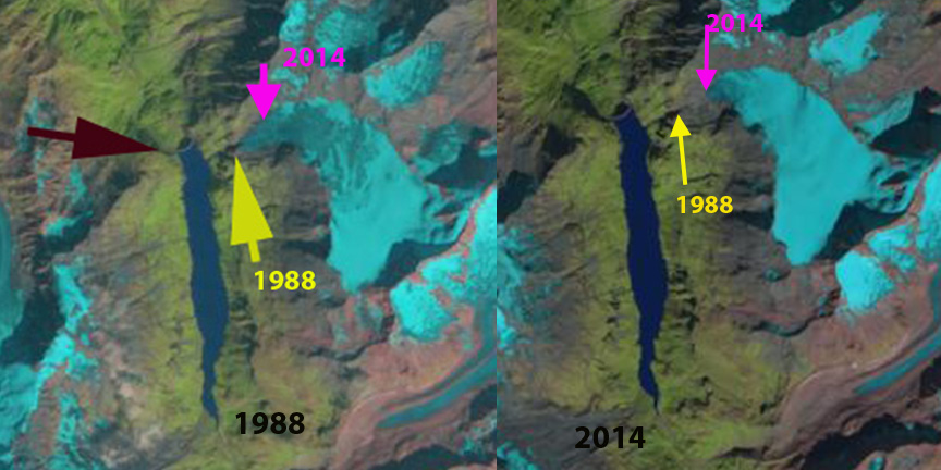
Gietro Glacier 1988 and 2014 Landsat image comparison.

2001 SCNAT image

2009 Google Earth view
 .
.
2012 terminus closeup
The glacier in 2009 has very limited snowcover by the end of the summer. A glacier to thrive should be 60% snowcovered at the end of the melt season, in this case it is less than 20%, green dots mark the main snowline below. The lack of snowcover indicates a negative mass balance that is driving the retreat. If the glacier consistently loses most of the accumulation zone snowcover it cannot survive (Pelto, 2010). In the Swiss Glacier Inventory(Kääb et al, 2002), noted a 21% loss in glacier area from 1973-1998, with almost all the change occurring after 1985. The retreat if this glacier is similar to that of other Swiss glaciers, Otemma Glacier, Ried Glacier and Triftgletscher
 Dean of Academic Affairs at Nichols College and Professor of Environmental Science at Nichols College in Massachusetts since 1989. Glaciologist directing the North Cascade Glacier Climate Project since 1984. This project monitors the mass balance and behavior of more glaciers than any other in North America.