September 3, 2011
Bridge Glacier Retreat Acceleration, BC, Canada
Posted by Mauri Pelto
Note an Update post on Bridge Glacier
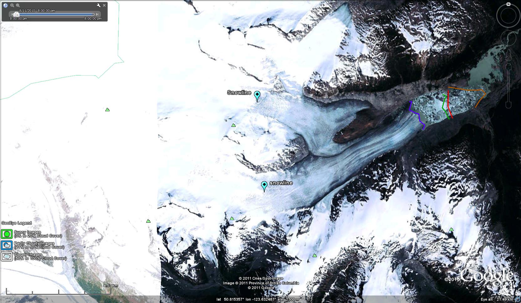
Bridge Glacier is an 17 km long outlet glacier of the Lillooet Icefield in British Columbia. The glacier ends in a rapidly expanding glacial lake with 1100 meters of retreat from 2005-2010. This 200+ m per year retreat is a substantial acceleration over the observed retreat rate of 30 m per year from 1981-2005 by Allen and Smith (2007). They examined the dendrolchronology of Holocene advances of the glacier and found up to 2005 a 3.3 kilometer advance from the primary terminal moraine band, with the most extensive advances being early in the Little Ice Age. The glacier currently ends at 1400 m and in 2010 had a late summer snowline of 2000 m.
Terminus positions through time of Bridge Glacier: orange =1970, red=2003, green=2005 and purple=2010
The glacier terminus in 1970 is shown in map form, and is indicated by a brown line. The 2003 terminus position from a Landsat image, second image, is next with a red line marking the terminus. The normal Google Earth image, third image, is from 2005 and has a green line. An image from Geoeye from August 2010, last image, terminus purple line indicates the rapid acceleration of retreat. Retreat from 1970-2003 was 48 m per year. The retreat from 2003 to 2010 is 1400 meters, 200 m per year. This continued retreat and area loss will lead to glacier runoff decline in summer. This is crucial to the large Bridge River Hydro complex. This complex managed by BC Hydro can produce 490 MW of power. Stahl et al (2008) note in their modeling study of the glacier that ,”The model results revealed that Bridge Glacier is significantly out of equilibrium with the current climate, and even when a continuation of current climate is assumed, the glacier decreases in area by 20% over the next 50 to 100 years. This retreat is accompanied by a similar decreasein summer streamflow.” This parallels our findings on the Skykomish River in the North Cascades, Washington Pelto (2008) and Pelto (2011).
1970 map terminus position
2003 Google Earth image of terminus
2005 terminus position in Google Earth
August 2010 Geoeye image


 Dean of Academic Affairs at Nichols College and Professor of Environmental Science at Nichols College in Massachusetts since 1989. Glaciologist directing the North Cascade Glacier Climate Project since 1984. This project monitors the mass balance and behavior of more glaciers than any other in North America.