
February 4, 2011
Grand Plateau Glacier Retreat, Alaska
Posted by Mauri Pelto
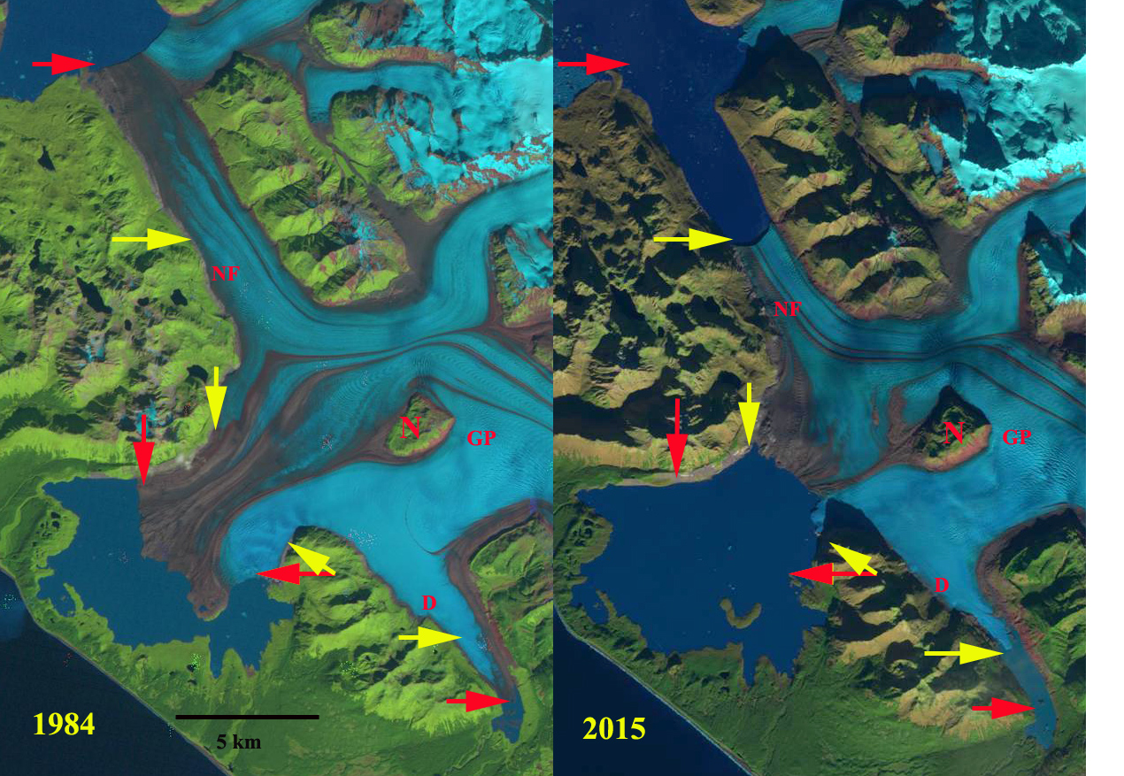
Grand Plateau Glacier in 1984 and 2015 Landsat images. Red arrow is the 1984 terminus location and yellow arrows the 2015 terminus locations. D=Distributary tongue, NF=North Fork, N=Nunatak, GP=Grand Plateau
Grand Plateau Glacier drains southwest from Mount Fairweather in southeast Alaska. The glacier advanced during the Little Ice age to the Alaskan coastline. Early maps from 1908 show no lake at the terminus of the glacier. The 1948 map shows three small distinct lakes at the terminus of the main glacier and a just developing lake at the terminus of the southern distributary terminus (D). By 1966 the glacier had retreated enough for the formation of one lake. The distance from the Nunatak N to the terminus was 12 km in 1948. The lake at D is 400 m wide.


USGS map displayed in Google Earth-1948 base images.
Landsat images from 1984, a Google Earth Mosaic of the 2003-2009 period and Landsat images from 2013 and 2015 indicate the substantial changes that have occurred. Here both the main terminus and a distributary (D) terminus draining south are examined. The main reference points in each image are the Nunatak, N, and and Island, I. The retreat from 1984-2013 is evident with the yellow arrows indicating the 1984 terminus and pink arrows showing the 2013 terminus location. The distance from the Nunatak to the terminus is 9.6 km in 1984, 6.8 km in the Google Earth image and 3.5 km in 2013. A six kilometer retreat at the glacier center in 30 years. On the north shore of the lake the retreat between arrows is 2.7 km from 1984-2013. From the island the glacier retreated 3.3 km from 1984-2013. The distributary tongue (D) retreated 2.2 km from 1984-2013. The offset of the terminus is 300-350 m indicating a five year retreat rate of 75-90 meters per year. The retreat has been driven by higher snowlines in recent years, the snowline had been reported at 3400 feet in the 1950’s. Satellite imagery of the last decade indicates snowlines averaging 1500 m, red arrows. The glacier snowline is evident in Landsat imagery in 2009 and 2013 red arrows. The combination of higher snowlines and increased calving into the terminus lake will continue to lead to retreat of this still mighty river of ice. This retreat parallels that of nearby Yakutat Glacier, Norris Glacier and Melbern Glacier

1984 Landsat image

2013 Landsat image

Google Earth images
 Dean of Academic Affairs at Nichols College and Professor of Environmental Science at Nichols College in Massachusetts since 1989. Glaciologist directing the North Cascade Glacier Climate Project since 1984. This project monitors the mass balance and behavior of more glaciers than any other in North America.