
January 27, 2011
Tungnaarjökull Retreat, Iceland
Posted by Mauri Pelto
Tungnaarjökull drains the west side of the Vatnojökull Icecap. The glacier begins just west of the Grimsvotn Volcano at 1500 m. Just to the north of this large outlet glacier, 350 square kilometers, is the Loki Volcano. The first image below denotes these volcanoes and the epicenter of recent earthquakes. The volcanic activity is recorded in the dark ash layers that fall on the glacier in the accumulation area and are subsequently buried to emerge in the ablation zone. The snowline is visible in the imagery just above the highest ash horizon. The glacier drains into the Skaftá River which experiences jökulhlaups such as in June 2015.A June 6, 2015 Landsat image indicates little ablation being generated in the area.
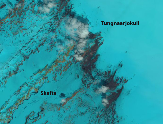
June 6, 2015 Landsat Image

Google Earth Images
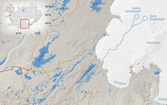
Iceland Met Service map of Skaftá River and jökulhlaup source.
The glacier terminates at 800 m, and has a snowline since 2000 averaging 1300 m. Like many of the glaciers draining the Vatnajökull the glacier experiences periodic surges. Surging is a short term, several months to several years, acceleration and the associated advance of a glacier that is not primarily dictated by changes in mass balance or climate. A surge is related to a change in the basal water pressure that in this region is related to volcanic activity. The glacier surged in 1920, 1945 and 1995, that latter surge led to an advance of 1175 m in 1995. From 1955-1970 the glacier retreated at a rate of 75 m/year. From 1973-1992 the glacier retreated 1400 m. The surge led to an advance of 1175 m in 1995 bringing the glacier back close to its 1973 position. Since then the glacier has continued to retreat. Tungnaarjökull terminus is surveyed each year and the data reported to the WGMS. From 1996-2000 the glacier retreated 80 m. From 2001-2010 the glacier retreated 640 m. Below is the margin of the glacier indicating the moraine from which the glacier receded after the 1945 surge, the 1995 surge did not emplace a moraine. A comparison of Landsat images from 1999 and 2014 illustrates the retreat. Note the expansion of the lakes and the formation of a new one at the red and yellow arrow. The exposure of new moraine ridges at the purple arrow also indicates retreat.

1999 Landsat image
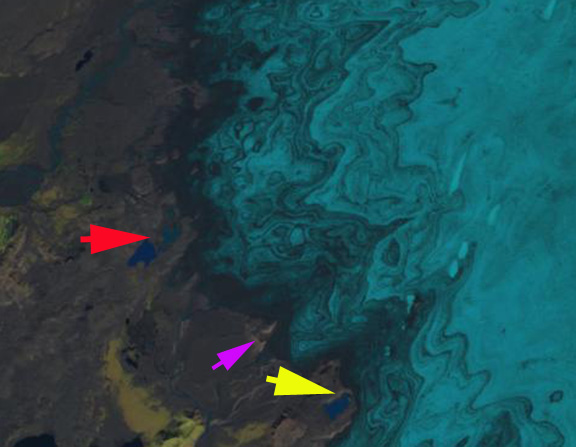
2015 Landsat image
The mass balance of this glacier has also been measured since 2000. During that period the glacier has had a negative balance every year, 12 of the 13 years the mass balance loss has been larger than 0.8 meter of water equivalent. The total loss for the period of 15 m, will lead to continued retreat. This is a substantial thinning of the glacier, but a small part of the total volume given a glacier that averages more than 500 m in thickness. The equilibrium line has been high since 2000, leading to only 40% of the glacier being snow covered at the end of the summer. on a glacier like this that lacks avalanche accumulation due to its low and consistent slope at least 60% of the glacier must be snow covered to have an equilibrium balance this would be 1150 m. This height is close to the elevation midpoint of the glacier.
Beyond the terminus the retreat is exposing a large relatively flat plain that is rich with glacial geologic deposits, many linear examples are evident. These features are streamline features from glacier flow. The retreat here is similar to the Bruarjokull on the north side and Skeidararjokulli on the west side of the Vatnojokull. 
 Dean of Academic Affairs at Nichols College and Professor of Environmental Science at Nichols College in Massachusetts since 1989. Glaciologist directing the North Cascade Glacier Climate Project since 1984. This project monitors the mass balance and behavior of more glaciers than any other in North America.