November 4, 2010
Stephenson Glacier retreat, Heard Island
Posted by Mauri Pelto
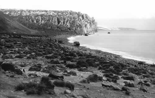
The Australian Antarctic Division manages Heard Island Island and has undertaken a project documenting changes in the environment on the island. One aspect noted has been the change in glaciers. The Allison, Brown and Stephenson Glacier have all retreated substantially since 1947 when the first good maps of their terminus are available. Fourteen Men by Arthur Scholes (1952) documents a year spent by fourteen men of the Australian National Antarctic Research Expedition. Their visit to the glacier noted that they could not skirt past the glacier along the coast. After crossing Stephenson Glacier they visited an old seal camp and counted 16,000 seals in the area Ensuing mapping and aerial photography has enabled a sequence of glacier boundary maps to be created that illustrate the changes in the glaciers. Thost and Truffer (2008) noted a 29% reduction in area of the Brown Glacier from 1947-2003. They also observed that the volcano Big Ben that the glaciers all drain from has shown no sign of changing geothermal output to cause the melting and that a 1 C warming has occurred over the same time period. Stephenson Glacier extends 8-9km down the eastern side of Big Ben. it 1947 it spread out into a piedmont lobe that was 3 km wide and extended to the ocean in two separate lobes around Elephant Spit. A picture from the Australian Antarctic Division taken in 1947 shows the glacier reaching the ocean and then in 2004 from the same location. 
 around then broadens to form a piedmont lobe up to -3 km wideKiernan and McConnell (2002) an order of magnitude increase in the rate of ice loss from Stephenson Glacier after 1987. Retreat from the late 19th century to 1955 had been limited.
  As Kiernan and McConnell observed retreat began to increased and by 1971 the glacier had retreated 1 km from the south coast and several hundred meters from the northern side of the spit. This retreat by 1980 caused the formation of Stephenson Lagoon and by 1987 Doppler Lagoon had formed as well. After 1997 the two lagoons have joined as Stephenson Glacier has retreated rapidly. The terminus is now 2.2 km from the south coast and 3.1 km from the north coast. The highly crevassed area above the terminus indicates the rapid ongoing flow of the glacier. The terminus is highly fractured in Google Earth Imagery indicating this section will continue to retreat via calving of icebergs into the lagoon, which is quite full as it is. The first image below shows the terminus location over the last 60 years from the Australian Antarctic Division. The second image are the AAD overlays that can be imported into Google Earth. The last image is a closeup of the still disintegrating terminus into the combined lagoons from 2008.

 The Stephenson Glacier is undergoing a rapid calving retreat that began due to ongoing mass balance loss. This mass balance loss is shared by the other glaciers on the island are observations, though the actual terminus retreat may be less the volume losses of Brown Glacier recently have been large.


 Dean of Academic Affairs at Nichols College and Professor of Environmental Science at Nichols College in Massachusetts since 1989. Glaciologist directing the North Cascade Glacier Climate Project since 1984. This project monitors the mass balance and behavior of more glaciers than any other in North America.