
October 21, 2010
Sara Umaga (Tos) Glacier, India snowline rise and retreat-Hydropower
Posted by Mauri Pelto
Sara Umaga Glacier drains into the Beas River in the Himachal Pradesh region of India. The glacier has retreated over 1600 meters since initial 1970. The glacier is also a key water source for hydropower, this will be detailed below. The glacier is 15 km long extending from 5600 m to 3900 m. The glacier has retreated at a rate of 44 meters/year from 1989-2004 (Kulkarni, 2005). The glacier is adjacent to the Chota Shingri Glacier which has retreated at a rate of 7 m/year from 1970-1989 and 27 m/year from 1990-2000. The retreat is the result of the rise of the equilibrium line, approximately the snowline at the end of the summer, where ablation equals accumulation. In the late 1980’s the snowline averaged 4700 m. In recent years the snowline has been a high as 5180 meters (Wagnon et al., 2007). This same rise has led to high snowlines on the Sara Umaga Glacier. In recent satellite images the snowline is above 4900 m, and the snowline is below where the ELA will be at the end of the melt season. The snowline and the head of the glacier are noted in the image below. This leaves only 20 % of the length of the glacier in the accumulation zone. In terms of area 25-30% of the area of the glacier has been above the current ELA. For a glacier to be in equilibrium at least 50% of the glacier must be in the accumulation zone. The Sara Umaga is retreating as it cannot sustain the large lower elevation ablation area. Retreat has revealed two vegetation trimlines. The older is a Little Ice Age trimline-the former the trimline is from the 1950-1970 period.
  This is an attempt to restore equilibrium. An examination of the heavily debris covered ablation zone indicates that the lowest 2.25 km of the glacier is stagnant and will melt away. The end of the stagnant zone is indicated by the green arrow and the change in thickness to the Little Ice Age lateral moraine by the brown arrow and the current terminus by the pink arrow.
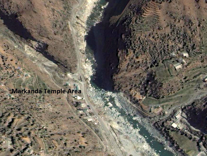
 . The lower section of the glacier is heavily debris covered which reduces melt rates. There is no apparent crevassing or convex shape to the glacier cross profile in the lower 2.25 km indicating stagnation. The debris covered section is not sensitive to soot deposition, as it is already sufficiently dark. The Glacier drains into the Beas River, which flows first through the Larji Hydropower project, which alters streamflow often leaving the stream below nearly dry. The Beas River is then impounded by the Pandoh Dam-and lake, third image below, which diverts water through a tunnel into the Saltuj (Sutlej) River, fourthimage, and thence the Bakrhra Dam at 1200 MW hydropower project. The tunnel from Pandoh is the largest tunneling project in Inida 13 km with a diameter of 8 m.
Larji Hydropower looking upstream to reservoir and beyond. Notice the influence of the dam on the river which is nearly dry below the dam on the date of the imagery near Markanada Temple.


 Dean of Academic Affairs at Nichols College and Professor of Environmental Science at Nichols College in Massachusetts since 1989. Glaciologist directing the North Cascade Glacier Climate Project since 1984. This project monitors the mass balance and behavior of more glaciers than any other in North America.